METAR & TAF 5V8
5V8 does not publish a METAR.
Showing the nearest reporting station: KPHP (PHILIP) · 13.7 NM away. Conditions at 5V8 may differ.
METAR · KPHP
Observed 16:55Z
KPHP 261655Z AUTO 28008G15KT 10SM CLR 37/16 A2980 RMK AO2 SLP060 T03670156
- Wind
- 280° @ 8G15 kt
- Visibility
- 10 SM
- Temp / Dew
- 37°C / 16°C
- Altimeter
- 29.80 inHg
- Clouds
- CLR
- Density alt
- 5,847 ft
- Ceiling
- Unlimited
- Rules
- VFR
Airport info & contacts
Manager on record, flight service, ARTCC, attendance schedule and pattern altitude — published by the FAA and refreshed every 28 days.
Location
- From city
- 1 NM E
- VFR sectional
- CHEYENNE
- ARTCC
- ZDV · DENVER
- NOTAM facility
- HON (NOTAM-D)
Airport manager
- Name
- PATRICK SOLON
- Phone
- 605-837-2140
- Address
- PO BOX 58, KADOKA SD 57543
Flight service · Hours
- FSS HON
- HURON1-800-WX-BRIEF
- Attendance
- Unattended
Frequencies
Tap any row to copy the frequency to your clipboard.
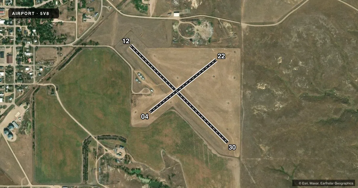
Runways & pattern
Full pagePattern entry · RWY 30
LEFT TRAFFICAirport sketch
Runways drawn to scale from FAA survey coordinates, rendered over satellite imagery. Not for navigation.
Approaches & charts
Services on the field
Fuel grades, oxygen, maintenance, ramp storage and lighting — as declared to the FAA by the airport operator.
Fuel & services
- Fuel
- Not available
- Oxygen (bottled)
- Not available
- Oxygen (bulk)
- Not available
- Airframe repair
- Not available
- Power plant repair
- Not available
Ramp & ground
- Transient storage
- Tie-down
- Landing fee
- No fee published
- Customs
- Not available
- Lighting schedule
- SEE RMK
- Beacon schedule
- SS-SR
- Beacon
- White / Green (civil land)(WG)
- Wind indicator
- Lighted
- Segmented circle
- No
Fuel & FBOs
Cheapest 100LL and Jet A on the field and nearby. Always confirm with the FBO before taxi.
Airport notes
Surface conditions, obstructions, local procedures, lighting outages and other notes published with each FAA cycle.
General notes
- FOR ASSISTANCE AFT HRS CTC CHIEF OF POLICE AT 605-837-2220 OR COUNTY SHERIFF AT 605-488-0059
- FOR CD CTC DENVER ARTCC AT 303-651-4257.
Lighting notes
- ACTVT LIRL RWY 12/30 - 122.8.
Runway surface & condition
- 12/30CNTR PTN OF RWY 12/30 IS TURF/AGGREGATE 2400 FT BY 50 FT.
Approach & departure obstructions
- 04MKD WITH WHITE & BLACK TIPPED MKR CONES.
- 12MKD WITH WHITE & BLACK TIPPED MKR CONES.
- 22MKD WITH WHITE & BLACK TIPPED MKR CONES.
- 30MKD WITH WHITE & BLACK TIPPED MKR CONES.
- 224 FT FENCE 85 FT L 300 FT FM THR & 125 FT L 248 FT FM THR.
- 304 FT FENCE 125 FT R 227 FT FM THR & 125 FT L 269 FT FM THR.
Other notes
- 12/30CTN: WATCH FOR HOLES MADE BY VARMINTS.
VFR map & nearby airports
VFR sectional. Tap any ICAO chip to open that airport.
Key facts · 5V8
Answer card- ICAO
- 5V8
- Name
- KADOKA MUNI
- Location
- KADOKA, SOUTH DAKOTA
- Elevation
- 2,466 ft MSL
- Traffic pattern altitude
- 3,466 ft MSL (1,000 AGL)
- Control tower
- Non-towered (use CTAF)
- Total runways
- 2
- Longest runway
- 12/30 · 2,600 ft
- Published ILS approaches
- 0
- Published frequencies
- 1
- Magnetic variation
- 10°
- Current flight rules
- VFR
- Current wind
- 280° at 8 kt
- Favored runway now
- RWY 30
KADOKA MUNI sits in Kadoka, South Dakota. The field elevation is 2,466 ft MSL. It has two runways. The longest is runway 12/30 at 2,600 ft. This is an unattended field with no control tower. CTAF is 122.9.
No ILS approaches are published here. Pattern altitude is not published, so use the standard 1,000 ft AGL for light piston operations unless the current FAA Chart Supplement says otherwise. Runway 12/30 has turf and aggregate in the center portion. The published remarks also call out varmints on runway 12/30. A careful walk or low pass makes sense before landing. Runway 12, runway 22, runway 30 and runway 04 are marked with white and black tipped marker cones. Low intensity runway lights on 12/30 are activated by radio on 122.8.
There are no on-field FBOs listed. Plan on self-sufficiency. For after-hours help, the published remarks list local police or the county sheriff. Clearance delivery is through Denver ARTCC. This is a high-elevation South Dakota strip with turf surfaces, so performance and surface condition deserve attention. Check the current FAA Chart Supplement before departure for any updates on pattern, lighting, or local procedures.