METAR & TAF 6V4
6V4 does not publish a METAR.
Showing the nearest reporting station: KPHP (PHILIP) · 28.4 NM away. Conditions at 6V4 may differ.
METAR · KPHP
Observed 11:55Z
KPHP 271155Z AUTO 00000KT 10SM CLR 24/15 A2987 RMK AO2 SLP085 60000 T02390150 10300 20233 53006
- Wind
- 000° @ 0 kt
- Visibility
- 10 SM
- Temp / Dew
- 24°C / 15°C
- Altimeter
- 29.87 inHg
- Clouds
- CLR
- Density alt
- 4,630 ft
- Ceiling
- Unlimited
- Rules
- VFR
Airport info & contacts
Manager on record, flight service, ARTCC, attendance schedule and pattern altitude — published by the FAA and refreshed every 28 days.
Location
- From city
- 1 NM NW
- VFR sectional
- CHEYENNE
- ARTCC
- ZDV · DENVER
- NOTAM facility
- HON (NOTAM-D)
Airport manager
- Name
- CITY OF WALL
- Phone
- 605-279-2663
- Address
- PO BOX 314, WALL SD 57790
Flight service · Hours
- FSS HON
- HURON1-800-WX-BRIEF
- Attendance
- Unattended
Frequencies
Tap any row to copy the frequency to your clipboard.
Runways & pattern
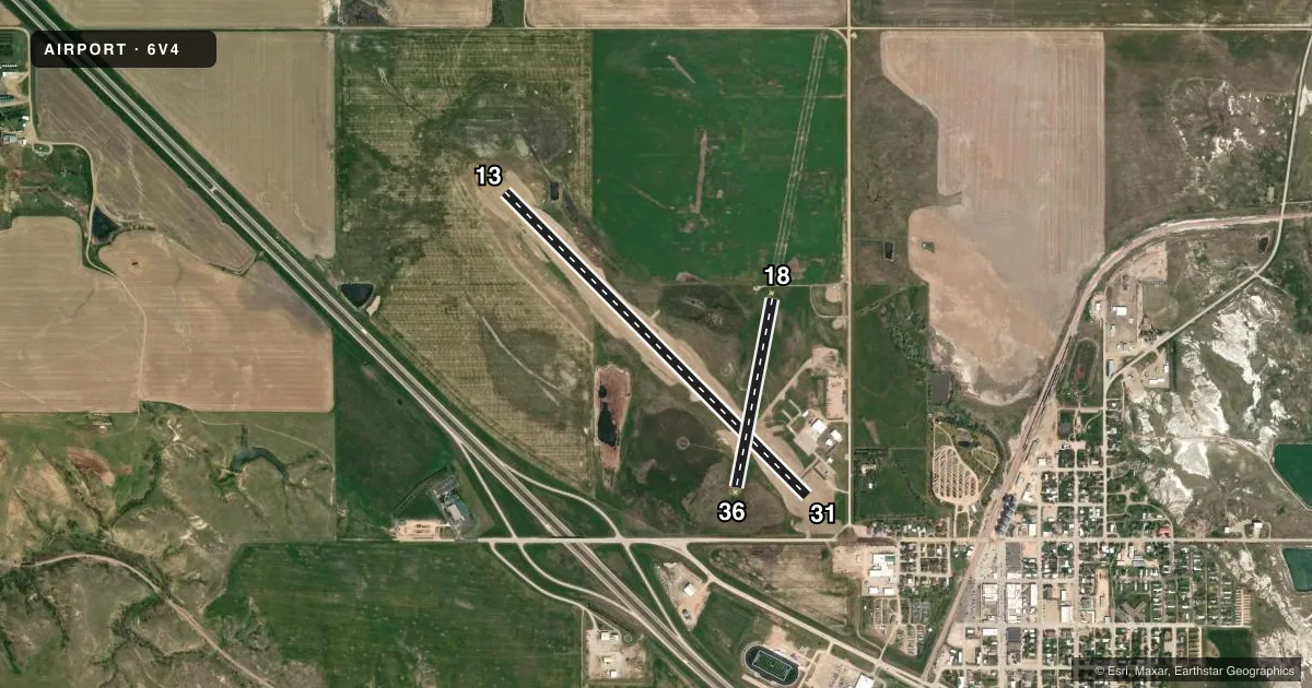
Full pagePattern entry · RWY 13
LEFT TRAFFIC| Runway | Heading (°M) | Length | Surface | Traffic |
|---|---|---|---|---|
| 13/31 | 125° / 305° | 4,419 ft | ASPH | Standard L |
| 18/36 | 181° / 1° | 1,981 ft | TURF | Standard L |
Runway end performance
| End | TORA | TODA | ASDA | LDA | VGSI | Approach lights | Obstruction |
|---|---|---|---|---|---|---|---|
| 13 | — | — | — | — | PAPI 2-box left(3°) | — | — |
| 31 | — | — | — | — | PAPI 2-box left(3°) | — | — |
| 36 | — | — | — | — | — | — | 59', tank, 1410' from thr, 225' R of cntrln, slope 23 |
Declared distances in feet. TORA = takeoff run available, TODA = takeoff distance, ASDA = accelerate-stop, LDA = landing distance.
Airport sketch
Runways drawn to scale from FAA survey coordinates, rendered over satellite imagery. Not for navigation.
Approaches & charts
Services on the field
Fuel grades, oxygen, maintenance, ramp storage and lighting — as declared to the FAA by the airport operator.
Fuel & services
- Fuel
- Not available
- Oxygen (bottled)
- Not available
- Oxygen (bulk)
- Not available
- Airframe repair
- Not available
- Power plant repair
- Not available
- Other services
- AGRI
Ramp & ground
- Transient storage
- Tie-down
- Hangar
- Landing fee
- No fee published
- Customs
- Not available
- Lighting schedule
- SEE RMK
- Beacon schedule
- SS-SR
- Beacon
- White / Green (civil land)(WG)
- Wind indicator
- Lighted
- Segmented circle
- Yes
Fuel & FBOs
Cheapest 100LL and Jet A on the field and nearby. Always confirm with the FBO before taxi.
Airport notes
Surface conditions, obstructions, local procedures, lighting outages and other notes published with each FAA cycle.
General notes
- DEER, ANTELOPE & WATERFOWL ON & INVOF ARPT.
- FOR CD CTC ELLSWORTH APCH AT 605-385-6198, WHEN APCH CLSD CTC DENVER ARTCC AT 303-651-4257.
Lighting notes
- LIRL RWY 13/31 OPR DUSK-2200; AFT 2200 ACTVT CTAF.
VFR map & nearby airports
VFR sectional. Tap any ICAO chip to open that airport.
Key facts · 6V4
Answer card- ICAO
- 6V4
- Name
- WALL MUNI
- Location
- WALL, SOUTH DAKOTA
- Elevation
- 2,813.3 ft MSL
- Traffic pattern altitude
- 3,813.3 ft MSL (1,000 AGL)
- Control tower
- Non-towered (use CTAF)
- Total runways
- 2
- Longest runway
- 13/31 · 4,419 ft
- Published ILS approaches
- 0
- Published frequencies
- 2
- Magnetic variation
- 10°
- Current flight rules
- VFR
- Current wind
- 000° at 0 kt
- Favored runway now
- –
Wall Muni Airport sits in Wall, South Dakota. The field elevation is 2,813.3 ft MSL. It has two runways. The longest is runway 13/31 at 4,419 ft on asphalt. Runway 18/36 is 1,981 ft on turf. This is an untowered field. CTAF and UNICOM are both 122.8.
No ILS approaches are published here. Pattern altitude is not published in the facts, so use the standard 1,000 ft AGL for light piston traffic unless the current FAA Chart Supplement says otherwise. That puts the traffic pattern at about 3,813 ft MSL based on the listed field elevation.
Published remarks matter here. Runway 13/31 has low intensity lights. They operate from dusk to 2200. After 2200, activate them on CTAF. Runway 18/36 is for emergency use only. Deer, antelope and waterfowl are reported on and near the airport, so keep a sharp scan on arrival and departure. For clearance delivery, contact Ellsworth Approach. If approach is closed, contact Denver ARTCC. There are no on-field FBOs listed in the facts. Verify fuel and services with the airport operator or the FBO directly by phone before you go.