METAR & TAF 49B
Current METAR
Observed 10:55Z
K49B 271055Z AUTO 28008KT 10SM CLR 24/16 A2993 RMK AO2
- Wind
- 280° @ 8 kt
- Visibility
- 10 SM
- Temp / Dew
- 24°C / 16°C
- Altimeter
- 29.93 inHg
- Clouds
- CLR
- Density alt
- 5,104 ft
- Ceiling
- Unlimited
- Rules
- VFR
Airport info & contacts
Manager on record, flight service, ARTCC, attendance schedule and pattern altitude — published by the FAA and refreshed every 28 days.
Location
- From city
- 4 NM E
- VFR sectional
- CHEYENNE
- ARTCC
- ZDV · DENVER
- NOTAM facility
- HON (NOTAM-D)
Airport manager
- Name
- ROGER BURNHAM
- Phone
- 605-720-9938
- Address
- 13345 ALKALI RD, STURGIS SD 57785
Flight service · Hours
- FSS HON
- HURON1-800-WX-BRIEF
- Attendance
- DALGT
Frequencies
Tap any row to copy the frequency to your clipboard.
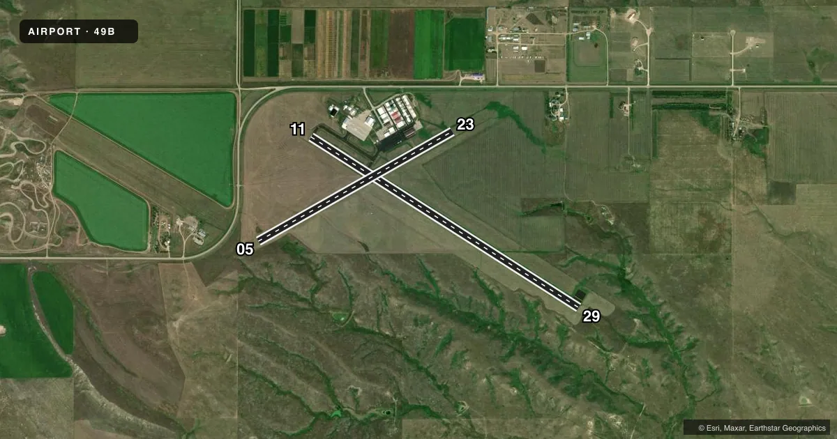
Runways & pattern
Full pagePattern entry · RWY 29
LEFT TRAFFIC| Runway | Heading (°M) | Length | Surface | Traffic |
|---|---|---|---|---|
| 11/29Favored | 112° / 292° | 5,100 ft | CONC | Standard L |
| 05/23 | 50° / 230° | 3,580 ft | TURF | Standard L |
Runway end performance
| End | TORA | TODA | ASDA | LDA | VGSI | Approach lights | Obstruction |
|---|---|---|---|---|---|---|---|
| 11 | — | — | — | — | PAPI 2-box left(3°) | — | — |
| 29 | — | — | — | — | PAPI 2-box left(3°) | — | — |
| 05 | — | — | — | — | — | — | 41', hill, 1099' from thr, 0' R of cntrln, slope 26 |
Declared distances in feet. TORA = takeoff run available, TODA = takeoff distance, ASDA = accelerate-stop, LDA = landing distance.
Airport sketch
Runways drawn to scale from FAA survey coordinates, rendered over satellite imagery. Not for navigation.
Approaches & charts
Services on the field
Fuel grades, oxygen, maintenance, ramp storage and lighting — as declared to the FAA by the airport operator.
Fuel & services
- Fuel
- 100LLA
- Airframe repair
- Major
- Power plant repair
- Major
- Other services
- AGRI,INSTR
Ramp & ground
- Transient storage
- Tie-down
- Hangar
- Lighting schedule
- SEE RMK
- Beacon schedule
- SS-SR
- Beacon
- White / Green (civil land)(WG)
- Wind indicator
- Lighted
- Segmented circle
- No
Fuel & FBOs
Cheapest 100LL and Jet A on the field and nearby. Always confirm with the FBO before taxi.
Airport notes
Surface conditions, obstructions, local procedures, lighting outages and other notes published with each FAA cycle.
General notes
- WILDLIFE ON AND INVOF ARPT.
- GCO AVBL ON FREQ 121.725 (4 CLICKS TO ELLSWORTH APPROACH AND 6 CLICKS TO DENVER CENTER)
- FOR CD IF UNA VIA GCO CTC DENVER ARTCC AT 303-651-4257.
- HIGH VOL OF ACFT OPRNG INVOF OF MT RUSHMORE AND CRAZY HORSE MONUMENTS AT OR BLW 7500 FT; PILOTS ARE ADVISED TO MNT 122.85 FOR TFC ADVISORIES.
Lighting notes
- ACTVT MIRL RWY 11/29; PAPI RWY 11 & 29 - CTAF.
Fuel notes
- 100LLFUEL AVBL 24 HRS WITH CREDIT CARD.
Other notes
- AUTOMATED UNICOM.
- 1FOR ATTENDANT OTR HRS CALL 605-347-1050.
VFR map & nearby airports
VFR sectional. Tap any ICAO chip to open that airport.
Key facts · 49B
Answer card- ICAO
- 49B
- Name
- STURGIS MUNI
- Location
- STURGIS, SOUTH DAKOTA
- Elevation
- 3,254.9 ft MSL
- Traffic pattern altitude
- 4,254.9 ft MSL (1,000 AGL)
- Control tower
- Non-towered (use CTAF)
- Total runways
- 2
- Longest runway
- 11/29 · 5,100 ft
- Published ILS approaches
- 0
- Published frequencies
- 5
- Magnetic variation
- 11°
- Current flight rules
- VFR
- Current wind
- 280° at 8 kt
- Favored runway now
- RWY 29
Sturgis Muni sits in Sturgis, South Dakota at 3,254.9 ft MSL. It has two runways. The longest is runway 11/29 at 5,100 ft of concrete. Runway 05/23 is 3,580 ft of turf. There is no control tower. CTAF and UNICOM are both 122.8. No ILS approaches are published here.
Pattern altitude is not published. Use the standard 1,000 ft AGL pattern unless current local guidance says otherwise. That puts the light piston pattern at about 4,255 ft MSL based on the field elevation.
C & B Aviation is on the field. It carries 100LL and Jet A. Fuel is available 24 hours with credit card. An attendant can be reached outside regular hours at the listed phone number. Medium intensity runway lighting is active on 11/29. PAPI is available on 11 and 29 and is controlled by CTAF.
This is a non-towered field with busy nearby traffic. Wildlife is reported on and near the airport. There is also a high volume of aircraft near Mount Rushmore and Crazy Horse Monuments at or below 7,500 ft. Monitor 122.85 for traffic advisories in that area. If you need clearance delivery and the GCO is not available, contact Denver ARTCC. The airport also has GCO service on 121.725 with access to Ellsworth Approach and Denver Center.