METAR & TAF KECS
Current METAR
Observed 13:35Z
KECS 271335Z AUTO 00000KT 10SM CLR 21/15 A3006 RMK AO2
- Wind
- 000° @ 0 kt
- Visibility
- 10 SM
- Temp / Dew
- 21°C / 15°C
- Altimeter
- 30.06 inHg
- Clouds
- CLR
- Density alt
- 5,727 ft
- Ceiling
- Unlimited
- Rules
- VFR
Airport info & contacts
Manager on record, flight service, ARTCC, attendance schedule and pattern altitude — published by the FAA and refreshed every 28 days.
Location
- From city
- 5 NM NW
- VFR sectional
- CHEYENNE
- ARTCC
- ZDV · DENVER
- NOTAM facility
- CPR (NOTAM-D)
Airport manager
- Name
- BYRAND STREETER
- Phone
- 307-746-4666
- Address
- PO BOX 699, NEWCASTLE WY 82701
Flight service · Hours
- FSS CPR
- CASPER1-800-WX-BRIEF
- Attendance
- MON-SAT · 0800-1700
Frequencies
Tap any row to copy the frequency to your clipboard.
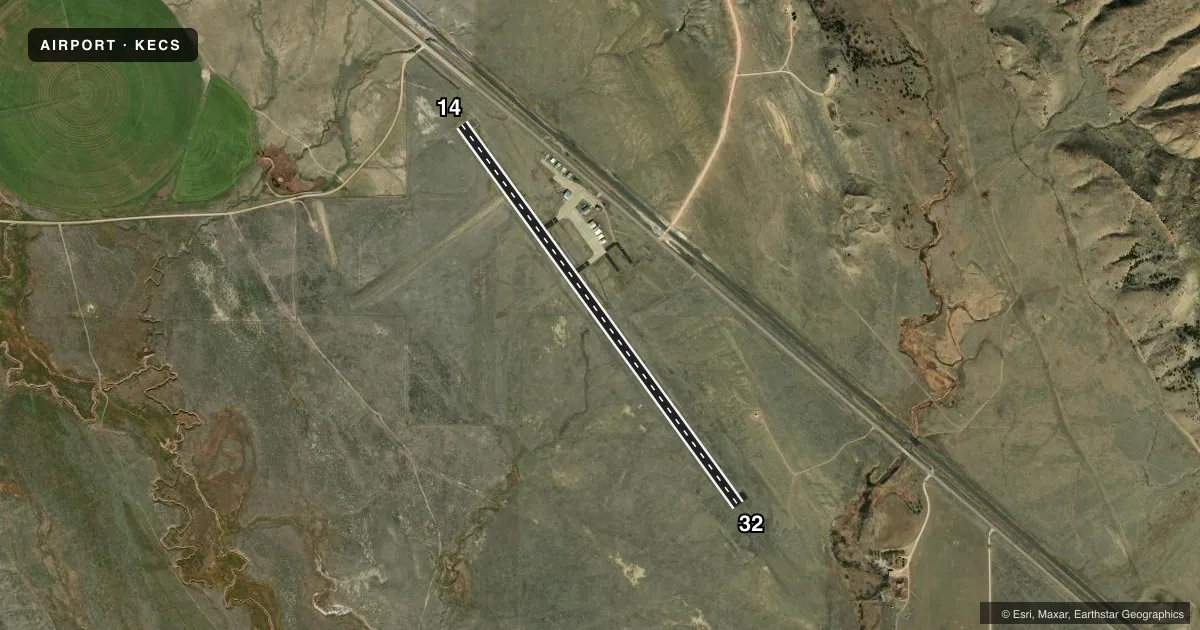
Runways & pattern
Full pagePattern entry · RWY 14
RIGHT TRAFFICRunway end performance
| End | TORA | TODA | ASDA | LDA | VGSI | Approach lights | Obstruction |
|---|---|---|---|---|---|---|---|
| 14 | — | — | — | — | PAPI 2-box left(3°) | — | 38', rr, 1184' from thr, 125' R of cntrln, slope 27 |
| 32 | — | — | — | — | PAPI 2-box left(3°) | ODALS | — |
Declared distances in feet. TORA = takeoff run available, TODA = takeoff distance, ASDA = accelerate-stop, LDA = landing distance.
Airport sketch
Runways drawn to scale from FAA survey coordinates, rendered over satellite imagery. Not for navigation.
Approaches & charts
Services on the field
Fuel grades, oxygen, maintenance, ramp storage and lighting — as declared to the FAA by the airport operator.
Fuel & services
- Fuel
- 100LLA
- Oxygen (bottled)
- Not available
- Oxygen (bulk)
- Not available
- Airframe repair
- Not available
- Power plant repair
- Not available
- Other services
- INSTR
Ramp & ground
- Transient storage
- Tie-down
- Hangar
- Landing fee
- No fee published
- Customs
- Not available
- Lighting schedule
- SEE RMK
- Beacon schedule
- SS-SR
- Beacon
- White / Green (civil land)(WG)
- Wind indicator
- Lighted
- Segmented circle
- Yes
Fuel & FBOs
Cheapest 100LL and Jet A on the field and nearby. Always confirm with the FBO before taxi.
Airport notes
Surface conditions, obstructions, local procedures, lighting outages and other notes published with each FAA cycle.
General notes
- WILDLIFE ON OR NEAR THE RWYS. MIGRATORY BIRD FLT PATHS NEAR ARPT.
- SOFT SHOULDERS NEAR EDGES OF RWYS, TWYS, & RAMPS.
- FOR CD IF UNA TO CTC ON FSS FREQ, CTC DENVER ARTCC AT 303-651-4257.
- HIGH VOL OF ACFT OPRNG INVOF OF MT RUSHMORE AND CRAZY HORSE MONUMENTS AT OR BLW 7500 FT; PILOTS ARE ADVISED TO MNT 122.85 FOR TFC ADVISORIES.
Lighting notes
- ACTVT ODALS RWY 32; REIL RWY 14; PAPI RWY 14 & 32; MIRL RWY 14/32 - CTAF.
Fuel notes
- 100LLFOR FUEL AFT HRS PHONE 307-746-5805.
Other notes
- EXISTED PRIOR TO 1959.
- PILOT SUPPLIED ROPES RQD FOR TIE DOWNS.
- 1UNATNDD MAJOR HOLS - CALL AFT HRS ON THESE DAYS.
- 1FOR ATTENDANT AFT HRS CALL 307-746-5805.
- OWNERPHONE NUMBER FOR CITY 307-746-3535
VFR map & nearby airports
VFR sectional. Tap any ICAO chip to open that airport.
Key facts · KECS
Answer card- ICAO
- KECS
- Name
- MONDELL FLD
- Location
- NEWCASTLE, WYOMING
- Elevation
- 4,177.5 ft MSL
- Traffic pattern altitude
- 5,177.5 ft MSL (1,000 AGL)
- Control tower
- Non-towered (use CTAF)
- Total runways
- 1
- Longest runway
- 14/32 · 5,310 ft
- Published ILS approaches
- 0
- Published frequencies
- 2
- Magnetic variation
- 8°
- Current flight rules
- VFR
- Current wind
- 000° at 0 kt
- Favored runway now
- –
Mondell Fld is in Newcastle, Wyoming. The field elevation is 4,177.5 ft MSL. It has one runway. Runway 14/32 is 5,310 ft long with asphalt pavement. There is no control tower. CTAF and UNICOM are both 122.8.
No ILS approaches are published here. The runway lighting is set up for night work. Runway 32 has an omni-directional approach lighting system. Runway 14 has runway end identifier lights. Both runway ends have PAPI. Medium intensity runway lights are published for 14/32. The pattern altitude is not published in the facts. A light piston pilot should plan on the standard 1,000 ft AGL unless the current FAA Chart Supplement says otherwise.
Tuff Air is on the field. It carries AVGAS 100LL, JET A and JET A Prist. Call (307) 746-4666 for current availability. The remarks also note wildlife on or near the runways. Migratory bird flight paths are near the airport. Soft shoulders are near the edges of the runways, taxiways and ramps. Pilot supplied ropes are required for tie downs. This is a non-towered field, so keep your scan tight and use CTAF. For traffic in the wider area, the remarks advise monitoring 122.85 near Mount Rushmore and Crazy Horse Monuments at or below 7,500 ft.