METAR & TAF KEFC
KEFC does not publish a METAR.
Showing the nearest reporting station: KSPF (BLACK HILLS-CLYDE ICE FLD) · 15.6 NM away. Conditions at KEFC may differ.
METAR · KSPF
Observed 12:35Z
KSPF 271235Z AUTO 00000KT 9SM -RA FEW050 FEW070 24/13 A3000 RMK AO2
- Wind
- 000° @ 0 kt
- Visibility
- 9 SM
- Temp / Dew
- 24°C / 13°C
- Altimeter
- 30.00 inHg
- Clouds
- FEW
- Density alt
- 4,937 ft
- Ceiling
- Unlimited
- Rules
- VFR
Airport info & contacts
Manager on record, flight service, ARTCC, attendance schedule and pattern altitude — published by the FAA and refreshed every 28 days.
Location
- From city
- 4 NM N
- VFR sectional
- BILLINGS
- ARTCC
- ZDV · DENVER
- NOTAM facility
- HON (NOTAM-D)
Airport manager
- Name
- JAMES DERANLEAU
- Phone
- 605-892-6345
- Address
- 10970 AIRPORT ROAD, BELLE FOURCHE SD 57717
Flight service · Hours
- FSS HON
- HURON1-800-WX-BRIEF
- Attendance
- 0800-1800
Frequencies
Tap any row to copy the frequency to your clipboard.
Runways & pattern
Full pagePattern entry · RWY 14
LEFT TRAFFIC| Runway | Heading (°M) | Length | Surface | Traffic |
|---|---|---|---|---|
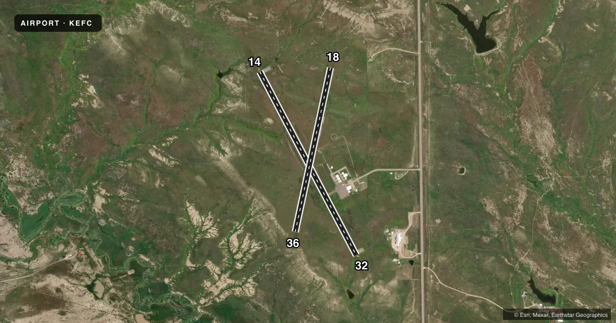
| 14/32 | 141° / 321° | 4,501 ft | ASPH | Standard L |
| 18/36 | 181° / 1° | 3,639 ft | TURF | Standard L |
Runway end performance
| End | TORA | TODA | ASDA | LDA | VGSI | Approach lights | Obstruction |
|---|---|---|---|---|---|---|---|
| 14 | — | — | — | — | PAPI 2-box left(3°) | — | — |
| 32 | — | — | — | — | PAPI 2-box left(3°) | — | — |
Declared distances in feet. TORA = takeoff run available, TODA = takeoff distance, ASDA = accelerate-stop, LDA = landing distance.
Airport sketch
Runways drawn to scale from FAA survey coordinates, rendered over satellite imagery. Not for navigation.
Approaches & charts
Services on the field
Fuel grades, oxygen, maintenance, ramp storage and lighting — as declared to the FAA by the airport operator.
Fuel & services
- Fuel
- 100LLA
- Airframe repair
- Major
- Power plant repair
- Major
- Other services
- AGRI,GLD,INSTR
Ramp & ground
- Transient storage
- Tie-down
- Hangar
- Lighting schedule
- SEE RMK
- Beacon schedule
- SS-SR
- Beacon
- White / Green (civil land)(WG)
- Wind indicator
- Lighted
- Segmented circle
- Yes
Fuel & FBOs
Cheapest 100LL and Jet A on the field and nearby. Always confirm with the FBO before taxi.
Airport notes
Surface conditions, obstructions, local procedures, lighting outages and other notes published with each FAA cycle.
General notes
- ULTRALIGHT OPNS ON & INVOF ARPT.
- WATERFOWL ON AND INVOF ARPT.
- FOR CD CTC DENVER ARTCC AT 303-651-4257.
- HIGH VOL OF ACFT OPRNG INVOF OF MT RUSHMORE AND CRAZY HORSE MONUMENTS AT OR BLW 7500 FT; PILOTS ARE ADVISED TO MNT 122.85 FOR TFC ADVISORIES.
Lighting notes
- ACTVT MIRL RWY 14/32 - CTAF.
Runway surface & condition
- 18/36MARKED WITH WHITE/BLACK MARKER CONES.
Other notes
- AUTOMATED UNICOM.
VFR map & nearby airports
VFR sectional. Tap any ICAO chip to open that airport.
Key facts · KEFC
Answer card- ICAO
- KEFC
- Name
- BELLE FOURCHE MUNI
- Location
- BELLE FOURCHE, SOUTH DAKOTA
- Elevation
- 3,190.6 ft MSL
- Traffic pattern altitude
- 4,190.6 ft MSL (1,000 AGL)
- Control tower
- Non-towered (use CTAF)
- Total runways
- 2
- Longest runway
- 14/32 · 4,501 ft
- Published ILS approaches
- 0
- Published frequencies
- 2
- Magnetic variation
- 11°
- Current flight rules
- VFR
- Current wind
- 000° at 0 kt
- Favored runway now
- –
Belle Fourche Muni sits in Belle Fourche, South Dakota. Field elevation is 3,190.6 ft MSL. The airport has two runways. The longest is 14/32 at 4,501 ft asphalt. Runway 18/36 is 3,639 ft turf. There is no control tower. CTAF and UNICOM are both 122.8. No ILS approaches are published here.
Pattern altitude is not published. Use the standard 1,000 ft AGL for light piston traffic unless local traffic or current guidance says otherwise. The field sits in a higher-elevation part of the Black Hills region, so performance planning matters on warm days. Published remarks also note waterfowl on and near the airport. Ultralight operations occur here too. That means a careful scan on base and final is smart.
Runway 14/32 has medium intensity lights that are activated by CTAF. Runway 18/36 is marked with white and black marker cones. There are no on-field FBOs listed in the facts. FBO options vary. Contact the airport operator directly before arrival, or call the field on CTAF/UNICOM for current FBO availability. For clearance delivery, contact Denver ARTCC at 303-651-4257. Pilots should also be aware of heavy traffic in the Mount Rushmore and Crazy Horse area at or below 7,500 ft. Monitor 122.85 for traffic advisories when operating in that area.