METAR & TAF 9D2
9D2 does not publish a METAR.
Showing the nearest reporting station: KBWW (BOWMAN RGNL) · 36.5 NM away. Conditions at 9D2 may differ.
METAR · KBWW
Observed 06:35Z
KBWW 270635Z AUTO 05006KT 10SM CLR 22/07 A2995 RMK AO2
- Wind
- 050° @ 6 kt
- Visibility
- 10 SM
- Temp / Dew
- 22°C / 7°C
- Altimeter
- 29.95 inHg
- Clouds
- CLR
- Density alt
- 4,388 ft
- Ceiling
- Unlimited
- Rules
- VFR
Airport info & contacts
Manager on record, flight service, ARTCC, attendance schedule and pattern altitude — published by the FAA and refreshed every 28 days.
Location
- From city
- 1 NM SE
- VFR sectional
- BILLINGS
- ARTCC
- ZLC · SALT LAKE CITY
- NOTAM facility
- HON (NOTAM-D)
Airport manager
- Name
- WILL HENDERSON
- Phone
- 605-375-3564
- Address
- BOX 165, BUFFALO SD 57720
Flight service · Hours
- FSS HON
- HURON1-800-WX-BRIEF
- Attendance
- Unattended
Frequencies
Tap any row to copy the frequency to your clipboard.
Runways & pattern
Full pagePattern entry · RWY 12
LEFT TRAFFICRunway end performance
| End | TORA | TODA | ASDA | LDA | VGSI | Approach lights | Obstruction |
|---|---|---|---|---|---|---|---|
| 12 | — | — | — | — | — | — | 4', fence, 366' from thr, 142' R of cntrln, slope 41 |
Declared distances in feet. TORA = takeoff run available, TODA = takeoff distance, ASDA = accelerate-stop, LDA = landing distance.
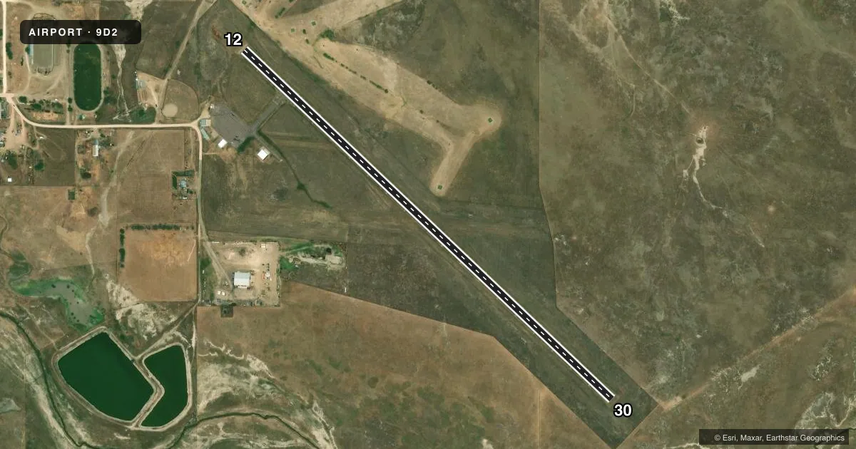
Airport sketch
Runways drawn to scale from FAA survey coordinates, rendered over satellite imagery. Not for navigation.
Approaches & charts
Services on the field
Fuel grades, oxygen, maintenance, ramp storage and lighting — as declared to the FAA by the airport operator.
Fuel & services
- Fuel
- 100LL
- Oxygen (bottled)
- Not available
- Oxygen (bulk)
- Not available
- Airframe repair
- Not available
- Power plant repair
- Not available
Ramp & ground
- Transient storage
- Tie-down
- Landing fee
- No fee published
- Customs
- Not available
- Beacon schedule
- SS-SR
- Beacon
- White / Green (civil land)(WG)
- Wind indicator
- Lighted
- Segmented circle
- Yes
Fuel & FBOs
Cheapest 100LL and Jet A on the field and nearby. Always confirm with the FBO before taxi.
Airport notes
Surface conditions, obstructions, local procedures, lighting outages and other notes published with each FAA cycle.
General notes
- WILDLIFE ON AND INVOF ARPT.
- FOR CD CTC SALT LAKE ARTCC AT 801-320-2568.
Fuel notes
- 100LLFOR FUEL CALL 605-375-3254/3255
VFR map & nearby airports
VFR sectional. Tap any ICAO chip to open that airport.
Key facts · 9D2
Answer card- ICAO
- 9D2
- Name
- HARDING COUNTY
- Location
- BUFFALO, SOUTH DAKOTA
- Elevation
- 2,891 ft MSL
- Traffic pattern altitude
- 3,891 ft MSL (1,000 AGL)
- Control tower
- Non-towered (use CTAF)
- Total runways
- 1
- Longest runway
- 12/30 · 3,900 ft
- Published ILS approaches
- 0
- Published frequencies
- 1
- Magnetic variation
- 11°
- Current flight rules
- VFR
- Current wind
- 050° at 6 kt
- Favored runway now
- RWY 12
Harding County Airport sits near Buffalo, South Dakota. The field elevation is 2,891 ft MSL. It has one runway. Runway 12/30 is 3,900 ft asphalt, so plan performance with the elevation in mind. There is no control tower. CTAF is 122.9.
No ILS approaches are published here. The pattern altitude is not published, so use standard traffic pattern planning unless the current FAA Chart Supplement says otherwise. Magnetic variation is 11°, so runway headings are published in magnetic terms. For clearance delivery, contact Salt Lake ARTCC at 801-320-2568.
No on-field FBOs are listed. For fuel, call 605-375-3254 or 605-375-3255 before you go. Wildlife is reported on and near the airport. Keep a sharp scan on taxi, takeoff and landing. This is a non-towered field in a rural area with a single short-to-medium asphalt runway. First-time pilots should review the current Chart Supplement, brief the CTAF flow and plan for local traffic and wildlife before arrival.