METAR & TAF KSPF
Current METAR
Observed 08:55Z
KSPF 270855Z AUTO 00000KT 10SM CLR 23/14 A3003 RMK AO2
- Wind
- 000° @ 0 kt
- Visibility
- 10 SM
- Temp / Dew
- 23°C / 14°C
- Altimeter
- 30.03 inHg
- Clouds
- CLR
- Density alt
- 5,701 ft
- Ceiling
- Unlimited
- Rules
- VFR
Airport info & contacts
Manager on record, flight service, ARTCC, attendance schedule and pattern altitude — published by the FAA and refreshed every 28 days.
Location
- From city
- 3 NM E
- VFR sectional
- CHEYENNE
- ARTCC
- ZDV · DENVER
- NOTAM facility
- SPF (NOTAM-D)
Airport manager
- Name
- CHANNING WAGNER
- Phone
- 701-590-2828
- Address
- 300 AVIATION PLACE, SPEARFISH SD 57783
Flight service · Hours
- FSS HON
- HURON1-800-WX-BRIEF
- Attendance
- 0730-DUSK
Frequencies
Tap any row to copy the frequency to your clipboard.
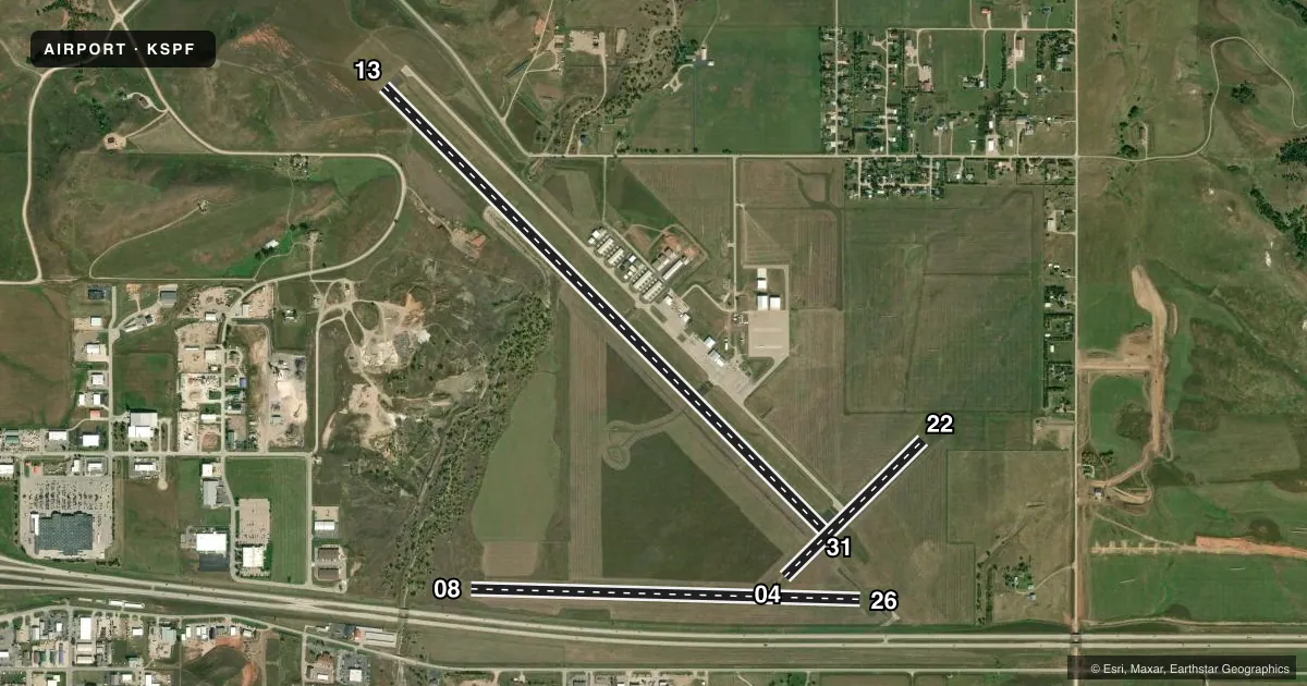
Runways & pattern
Full pagePattern entry · RWY 13
RIGHT TRAFFIC| Runway | Heading (°M) | Length | Surface | Traffic |
|---|---|---|---|---|
| 13/31 | 124° / 304° | 6,401 ft | ASPH | 13 R |
| 08/26 | 81° / 261° | 4,003 ft | TURF | Standard L |
| 04/22 | 34° / 214° | 1,995 ft | TURF | Standard L |
Runway end performance
| End | TORA | TODA | ASDA | LDA | VGSI | Approach lights | Obstruction |
|---|---|---|---|---|---|---|---|
| 13 | — | — | — | — | PAPI 4-box left(3°) | — | 98', hill, 2160' from thr, 380' R of cntrln, slope 20 |
| 31 | — | — | — | — | PAPI 4-box left(3°) | — | — |
| 04 | — | — | — | — | — | — | 18', road, 650' from thr, 0' R of cntrln, slope 36 |
| 22 | — | — | — | — | — | — | 1', fence, 150' from thr, 0' R of cntrln, slope 50 |
Declared distances in feet. TORA = takeoff run available, TODA = takeoff distance, ASDA = accelerate-stop, LDA = landing distance.
Airport sketch
Runways drawn to scale from FAA survey coordinates, rendered over satellite imagery. Not for navigation.
Approaches & charts
Services on the field
Fuel grades, oxygen, maintenance, ramp storage and lighting — as declared to the FAA by the airport operator.
Fuel & services
- Fuel
- 100LLA
- Oxygen (bottled)
- High pressure
- Oxygen (bulk)
- High pressure
- Airframe repair
- Major
- Power plant repair
- Major
- Other services
- AFRT,AGRI,AMB,CARGO,CHTR,GLD,INSTR,RNTL,SALES,SURV
Ramp & ground
- Transient storage
- Tie-down
- Hangar
- Landing fee
- No fee published
- Customs
- Not available
- Lighting schedule
- SEE RMK
- Beacon schedule
- SS-SR
- Beacon
- White / Green (civil land)(WG)
- Wind indicator
- Lighted
- Segmented circle
- Yes
Fuel & FBOs
Cheapest 100LL and Jet A on the field and nearby. Always confirm with the FBO before taxi.
Airport notes
Surface conditions, obstructions, local procedures, lighting outages and other notes published with each FAA cycle.
General notes
- IREG OPNS IN & OUT OF PVT AIRFIELD LOCATED APRXLY 3300 FT S OF ARPT; CHECK CTAF FREQ FOR STATUS.
- RY 22 +4 FT FENCE 50 FT R 141 FT FM THLD & 50 FT L 175 FT FM THLD.,
- NO SNOW REMOVAL ON TURF RYS, CFM CONDS WITH AMGR, CALL 605-642-4112/2656.
- ULTRALIGHT ACTIVITY ON & INVOF ARPT.
- GCO AVBL ON FREQ 121.725 (4 CLICKS TO ELLSWORTH APPROACH AND 6 CLICKS TO DENVER CENTER)
- FOR CD CTC ELLSWORTH APCH AT 605-385-6198, WHEN APCH CLSD CTC DENVER ARTCC AT 303-651-4257.
- HIGH VOL OF ACFT OPRNG INVOF OF MT RUSHMORE AND CRAZY HORSE MONUMENTS AT OR BLW 7500 FT; PILOTS ARE ADVISED TO MNT 122.85 FOR TFC ADVISORIES.
- COLD TEMPERATURE AIRPORT. ALTITUDE CORRECTION REQUIRED AT OR BELOW -30C.
Lighting notes
- ACTVT MIRL RY 13/31; PAPI RYS 13 & 31 AND TWY A LGTS- CTAF.
Approach & departure obstructions
- 04RY 04/22 & RY 08/26 MARKED WITH BLACK & WHITE EDGE MARKERS.
Other notes
- 2FOR ATTENDANT AFT HRS CALL 605-642-2656/641-2787.
VFR map & nearby airports
VFR sectional. Tap any ICAO chip to open that airport.
Key facts · KSPF
Answer card- ICAO
- KSPF
- Name
- BLACK HILLS-CLYDE ICE FLD
- Location
- SPEARFISH, SOUTH DAKOTA
- Elevation
- 3,933.1 ft MSL
- Traffic pattern altitude
- 4,933.1 ft MSL (1,000 AGL)
- Control tower
- Non-towered (use CTAF)
- Total runways
- 3
- Longest runway
- 13/31 · 6,401 ft
- Published ILS approaches
- 0
- Published frequencies
- 5
- Magnetic variation
- 11°
- Current flight rules
- VFR
- Current wind
- 000° at 0 kt
- Favored runway now
- –
Black Hills-Clyde Ice Fld sits in Spearfish, South Dakota. The field elevation is 3,933.1 ft MSL. It has three runways. The longest is 6,401 ft asphalt runway 13/31. The airport is not towered. No ILS approaches are published. Pattern altitude is not published, so use standard 1,000 ft AGL for light piston traffic unless local procedures say otherwise.
Eagle Aviation is on the field. It carries 100LL and Jet A Prist. Call (605) 642-4112 for current service details. Published remarks note medium intensity runway lights on 13/31. PAPI is available on runways 13 and 31. Taxiway A lights are controlled by CTAF. Runways 04/22 and 08/26 use black and white edge markers. There is also a cold temperature note. Altitude correction is required at or below minus 30 C.
This is a high-elevation airport, so performance planning matters. The area also has a lot of traffic near Mount Rushmore and Crazy Horse at or below 7,500 ft. Monitor 122.85 for traffic advisories. Ultralight activity is also reported in the area. If you need clearance delivery, contact Ellsworth Approach. If approach is closed, use Denver ARTCC. Turf runways have no snow removal, so check surface condition before you go.