METAR & TAF W43
Current METAR
Observed 12:15Z
KW43 271215Z AUTO 10SM CLR 20/14 A3004 RMK AO2
- Wind
- Calm
- Visibility
- 10 SM
- Temp / Dew
- 20°C / 14°C
- Altimeter
- 30.04 inHg
- Clouds
- CLR
- Density alt
- 5,738 ft
- Ceiling
- Unlimited
- Rules
- VFR
Airport info & contacts
Manager on record, flight service, ARTCC, attendance schedule and pattern altitude — published by the FAA and refreshed every 28 days.
Location
- From city
- 2 NM SE
- VFR sectional
- BILLINGS
- ARTCC
- ZDV · DENVER
- NOTAM facility
- CPR (NOTAM-D)
Airport manager
- Name
- TOWN OF HULETT
- Phone
- 307-467-5771
- Address
- P.O. BOX 278, HULETT WY 82720
Flight service · Hours
- FSS CPR
- CASPER1-800-WX-BRIEF
- Attendance
- Unattended
Frequencies
Tap any row to copy the frequency to your clipboard.
Runways & pattern
Full pagePattern entry · RWY 13
LEFT TRAFFICRunway end performance
| End | TORA | TODA | ASDA | LDA | VGSI | Approach lights | Obstruction |
|---|---|---|---|---|---|---|---|
| 13 | — | — | — | — | PAPI 2-box left(3°) | — | — |
| 31 | — | — | — | — | PAPI 2-box left(4°) | — | 165', hill, 3900' from thr, 425' R of cntrln, slope 22 |
Declared distances in feet. TORA = takeoff run available, TODA = takeoff distance, ASDA = accelerate-stop, LDA = landing distance.
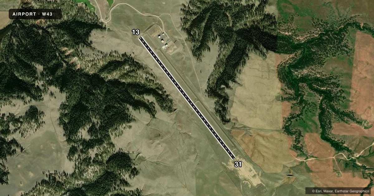
Airport sketch
Runways drawn to scale from FAA survey coordinates, rendered over satellite imagery. Not for navigation.
Approaches & charts
Services on the field
Fuel grades, oxygen, maintenance, ramp storage and lighting — as declared to the FAA by the airport operator.
Fuel & services
- Fuel
- 100LLA
- Oxygen (bottled)
- Not available
- Oxygen (bulk)
- Not available
- Airframe repair
- Not available
- Power plant repair
- Not available
Ramp & ground
- Transient storage
- Tie-down
- Lighting schedule
- SEE RMK
- Beacon schedule
- SS-SR
- Beacon
- White / Green (civil land)(WG)
- Wind indicator
- Lighted
- Segmented circle
- Yes
Fuel & FBOs
Cheapest 100LL and Jet A on the field and nearby. Always confirm with the FBO before taxi.
Airport notes
Surface conditions, obstructions, local procedures, lighting outages and other notes published with each FAA cycle.
General notes
- DEVILS TOWER NATIONAL MONUMENT LOCATED APRXLY 7 MILES SW OF THE ARPT. VOLUNTARY 2 MILE FLIGHT AVOIDANCE RADIUS IN EFFECT JAN-MAY AND JUL-DEC. VOLUNTARY 3 MILE FLIGHT AVOIDANCE RADIUS IN EFFECT IN JUN.
- RETRO-REFLECTIVE MARKERS ALONG TAXIWAYS
- FOR CD CTC DENVER ARTCC AT 303-651-4257.
Lighting notes
- ACTVT REIL RWY 13 & 31; PAPI RWY 13 & 31; MIRL 13/31 - CTAF.
Fuel notes
- 100LL24 HR SELF SVC CREDIT CARD FUEL AVBL.
Other notes
- PILOT SUPPLIED ROPES RQRD FOR TIE DOWNS.
- MANAGERMELISSA BEARS, TOWN CLERK
VFR map & nearby airports
VFR sectional. Tap any ICAO chip to open that airport.
Key facts · W43
Answer card- ICAO
- W43
- Name
- HULETT MUNI
- Location
- HULETT, WYOMING
- Elevation
- 4,263.7 ft MSL
- Traffic pattern altitude
- 5,263.7 ft MSL (1,000 AGL)
- Control tower
- Non-towered (use CTAF)
- Total runways
- 1
- Longest runway
- 13/31 · 5,500 ft
- Published ILS approaches
- 0
- Published frequencies
- 2
- Magnetic variation
- 10°
- Current flight rules
- VFR
- Current wind
- Calm / unavailable
- Favored runway now
- –
Hulett Muni sits in Hulett, Wyoming. The field elevation is 4,263.7 ft MSL. It has one runway. Runway 13/31 is 5,500 ft asphalt, so it gives you a workable strip for light aircraft and many turbine arrivals. The airport is non-towered. CTAF and UNICOM are both 122.8. No ILS approaches are published here.
Pattern altitude is not published. Use the standard 1,000 ft AGL pattern unless local procedures or current chart data say otherwise. Runway end identifier lights, PAPI and medium intensity runway lights are installed on 13/31. Lighting activation uses the common traffic advisory frequency. That matters after dark because this is a rural field with no tower to coordinate you in.
Hulett Municipal Airport is on the field. It carries AVGAS 100LL and JET A. Twenty-four hour self-serve credit card fuel is available. Pilot supplied ropes are required for tie downs. Devils Tower National Monument is about 7 miles southwest of the airport. There is a voluntary flight avoidance radius around the monument. Check the current FAA Chart Supplement before you go so you have the latest guidance and any local operating notes. For clearance delivery, contact Denver ARTCC. The airport manager is Melissa Bears.