METAR & TAF KGCC
Current METAR
Observed 12:53Z
KGCC 271253Z AUTO 17013KT 10SM CLR 24/13 A3003 RMK AO2 SLP103 T02390133
- Wind
- 170° @ 13 kt
- Visibility
- 10 SM
- Temp / Dew
- 24°C / 13°C
- Altimeter
- 30.03 inHg
- Clouds
- CLR
- Density alt
- 6,356 ft
- Ceiling
- Unlimited
- Rules
- VFR
Airport info & contacts
Manager on record, flight service, ARTCC, attendance schedule and pattern altitude — published by the FAA and refreshed every 28 days.
Location
- From city
- 4 NM NW
- VFR sectional
- CHEYENNE
- Pattern altitude
- 800 ft AGL · 5,165 ft MSL
- ARTCC
- ZDV · DENVER
- NOTAM facility
- GCC (NOTAM-D)
Airport manager
- Name
- TODD CHATFIELD
- Phone
- 307-686-1042
- Address
- 307 TERMINAL LOOP, SUITE 108, GILLETTE WY 82716
Flight service · Hours
- FSS CPR
- CASPER1-800-WX-BRIEF
- Attendance
- 0500-0000
Frequencies
Tap any row to copy the frequency to your clipboard.
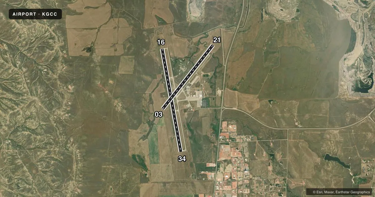
Runways & pattern
Full pagePattern entry · RWY 16
LEFT TRAFFIC| Runway | Heading (°M) | Length | Surface | Traffic |
|---|---|---|---|---|
| 16/34Favored | 161° / 341° | 7,501 ft | CONC | Standard L |
| 03/21 | 29° / 209° | 5,804 ft | CONC | Standard L |
Runway end performance
| End | TORA | TODA | ASDA | LDA | VGSI | Approach lights | Obstruction |
|---|---|---|---|---|---|---|---|
| 16 | 7,500' | 7,500' | 7,500' | 7,500' | PAPI 4-box left(3.17°) | — | 56', road, 1600' from thr, 0' R of cntrln, slope 25 |
| 34 | 7,500' | 7,500' | 7,500' | 7,500' | PAPI 4-box left(3.2°) | MALSR | 312', pline, 9732' from thr, 1351' R of cntrln, slope 30 |
| 03 | 5,803' | 5,803' | 5,803' | 5,803' | PAPI 4-box left(4°) | — | — |
| 21 | 5,803' | 5,803' | 5,803' | 5,803' | PAPI 4-box left(4°) | — | — |
Declared distances in feet. TORA = takeoff run available, TODA = takeoff distance, ASDA = accelerate-stop, LDA = landing distance.
Airport sketch
Runways drawn to scale from FAA survey coordinates, rendered over satellite imagery. Not for navigation.
Approaches & charts
ILS · 1
Services on the field
Fuel grades, oxygen, maintenance, ramp storage and lighting — as declared to the FAA by the airport operator.
Fuel & services
- Fuel
- 100LLAA+
- Oxygen (bottled)
- Not available
- Oxygen (bulk)
- HIGH/LOW
- Airframe repair
- Not available
- Power plant repair
- Not available
- Other services
- AFRT,CARGO,CHTR,INSTR,RNTL,SALES,SURV
Ramp & ground
- Transient storage
- Tie-down
- Hangar
- Landing fee
- No fee published
- Customs
- Not available
- Lighting schedule
- SEE RMK
- Beacon schedule
- SS-SR
- Beacon
- White / Green (civil land)(WG)
- Wind indicator
- Lighted
- Segmented circle
- Yes
Fuel & FBOs
Cheapest 100LL and Jet A on the field and nearby. Always confirm with the FBO before taxi.
Airport notes
Surface conditions, obstructions, local procedures, lighting outages and other notes published with each FAA cycle.
General notes
- MINING/BLASTING OPNS 1/2 MILE N OF AOA DURG DALGT HRS.
- BIRDS INVOF ARPT.
- CONDS UNMON.
- OPN ON UNPAVED SFCS PROHIBITED.
- AFT HRS OPS CTC - 307-257-3137
Lighting notes
- ACTVT MALSR RWY 34; REILS RWYS 03, 16, &21; HIRL RWY 16/34; MIRL RWY 03/21 - CTAF. SEQUENCE FLASHERS RWY 34 AVBL ON HIGH SETTING ONLY. PAPI RWYS 03, 16, 21, 34 OPR CONSLY.
Fuel notes
- 100LLFUEL AVBL H24 VIA CREDIT CARD.
Runway surface & condition
- 03/21PCR VALUE: 240/R/D/W/T
- 16/34PCR VALUE: 580/R/D/W/T
Approach & departure obstructions
- 16+56 FT BLDG 1600 FT FM RWY END 568 FT R.
Other notes
- ESTABLISHED PRIOR TO 1959.
- PPR UNSKED ACR OPNS WITH MORE THAN 30 PSGR SEATS CALL AMGR 307-686-1042.
- TPA: 800 FT AGL LGT ACFT, 1200 FT AGL LRG ACFT.
- MANAGER307-686-1042
VFR map & nearby airports
VFR sectional. Tap any ICAO chip to open that airport.
Key facts · KGCC
Answer card- ICAO
- KGCC
- Name
- NORTHEAST WYOMING RGNL
- Location
- GILLETTE, WYOMING
- Elevation
- 4,365.1 ft MSL
- Traffic pattern altitude
- 5,165.1 ft MSL (800 AGL)
- Control tower
- Non-towered (use CTAF)
- Total runways
- 2
- Longest runway
- 16/34 · 7,501 ft
- Published ILS approaches
- 1
- Published frequencies
- 2
- Magnetic variation
- 9°
- Current flight rules
- VFR
- Current wind
- 170° at 13 kt
- Favored runway now
- RWY 16
Northeast Wyoming Rgnl sits in Gillette, Wyoming. Field elevation is 4,365.1 ft MSL. The airport has two concrete runways. The longest is 16/34 at 7,501 ft. There is no control tower. CTAF is 118.5 and UNICOM is 122.95. Pattern altitude is 800 ft AGL, which is 5,165.1 ft MSL.
One ILS approach is published for runway 34. The field is non-towered, so expect self-announce traffic and keep a close ear on CTAF. The airport is unmonitored. Birds are reported in the vicinity. Mining and blasting operations occur one-half mile north of the airport during daylight hours. Plan for that when you are working arrivals or departures. Unpaved surface operations are prohibited.
Thunder Basin Aviation is on the field. It carries 100LL, Jet A and Jet A Prist. 100LL is available 24 hours a day via credit card. After hours operations use the published airport contact number. Runway lighting is worth a close look before night work. Runway 16/34 has high intensity lights. Runway 03/21 uses medium intensity lights controlled by CTAF. Runway 34 also has approach lighting with runway alignment indicator lights. If you are bringing a larger aircraft, note the published prior permission requirement for unscheduled operations with more than 30 passenger seats.