METAR & TAF KBYG
Current METAR
Observed 21:53Z
KBYG 262153Z AUTO 35008KT 10SM CLR 34/11 A3006 RMK AO2 LTG DSNT NW SLP106 T03440111
- Wind
- 350° @ 8 kt
- Visibility
- 10 SM
- Temp / Dew
- 34°C / 11°C
- Altimeter
- 30.06 inHg
- Clouds
- CLR
- Density alt
- 8,269 ft
- Ceiling
- Unlimited
- Rules
- VFR
Airport info & contacts
Manager on record, flight service, ARTCC, attendance schedule and pattern altitude — published by the FAA and refreshed every 28 days.
Location
- From city
- 3 NM NW
- VFR sectional
- CHEYENNE
- ARTCC
- ZLC · SALT LAKE CITY
- NOTAM facility
- BYG (NOTAM-D)
Airport manager
- Name
- BRUCE MCWHORTER
- Phone
- 307-684-9672
- Address
- 158 AIRPORT RD, BUFFALO WY 82834
Flight service · Hours
- FSS CPR
- CASPER1-800-WX-BRIEF
- Attendance
- MON-FRI · 0800-1700
- SAT · 0800-1200
Frequencies
Tap any row to copy the frequency to your clipboard.
Runways & pattern
Full pagePattern entry · RWY 31
LEFT TRAFFICRunway end performance
| End | TORA | TODA | ASDA | LDA | VGSI | Approach lights | Obstruction |
|---|---|---|---|---|---|---|---|
| 13 | — | — | — | — | PAPI 4-box left(3°) | — | — |
| 31 | — | — | — | — | PAPI 4-box left(3°) | — | — |
Declared distances in feet. TORA = takeoff run available, TODA = takeoff distance, ASDA = accelerate-stop, LDA = landing distance.
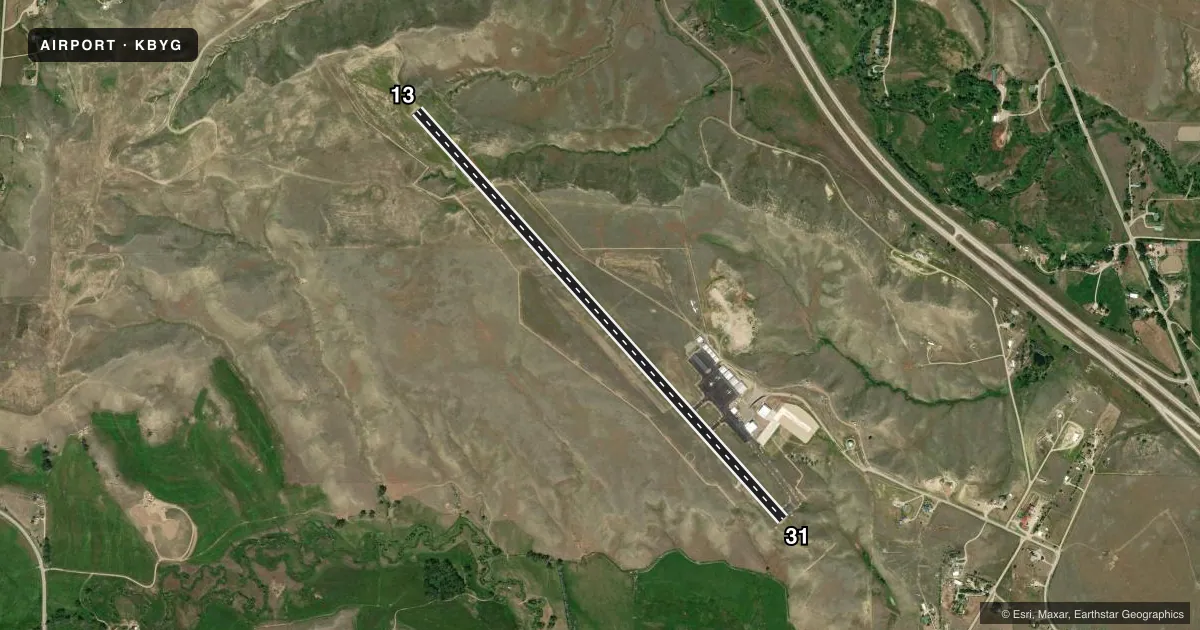
Airport sketch
Runways drawn to scale from FAA survey coordinates, rendered over satellite imagery. Not for navigation.
Approaches & charts
Services on the field
Fuel grades, oxygen, maintenance, ramp storage and lighting — as declared to the FAA by the airport operator.
Fuel & services
- Fuel
- 100LLA
- Oxygen (bottled)
- Not available
- Oxygen (bulk)
- Not available
- Airframe repair
- Major
- Power plant repair
- Major
Ramp & ground
- Transient storage
- Tie-down
- Hangar
- Landing fee
- No fee published
- Customs
- Not available
- Lighting schedule
- SEE RMK
- Beacon schedule
- SS-SR
- Beacon
- White / Green (civil land)(WG)
- Wind indicator
- Lighted
- Segmented circle
- Yes
Fuel & FBOs
Cheapest 100LL and Jet A on the field and nearby. Always confirm with the FBO before taxi.
Airport notes
Surface conditions, obstructions, local procedures, lighting outages and other notes published with each FAA cycle.
General notes
- TERRAIN DROPS OFF BOTH SIDES OF RY 13/31.
- DEER ON AND INVOF ARPT.
- RWY 31 +250' DROP 170'L FIRST 417'
- FOR CD CTC SALT LAKE ARTCC AT 801-320-2568.
Lighting notes
- ACTVT MIRL RY 13/31 & PAPI RYS 13 & 31 AND REIL RY 31 - 122.8.
Fuel notes
- 100LLAVBL H24 HR VIA SELF SVC CREDIT CARD.
- AFOR JET A AFT HRS PHONE 307-217-2060 OR 210-287-1548.
Other notes
- PILOT SUPD TIE DOWN ROPES RQRD.
- 1FOR SVC AFTER HRS CALL 307-217-2060 OR 210-287-1548.
VFR map & nearby airports
VFR sectional. Tap any ICAO chip to open that airport.
Key facts · KBYG
Answer card- ICAO
- KBYG
- Name
- JOHNSON COUNTY
- Location
- BUFFALO, WYOMING
- Elevation
- 4,970 ft MSL
- Traffic pattern altitude
- 5,970 ft MSL (1,000 AGL)
- Control tower
- Non-towered (use CTAF)
- Total runways
- 1
- Longest runway
- 13/31 · 6,143 ft
- Published ILS approaches
- 0
- Published frequencies
- 2
- Magnetic variation
- 12°
- Current flight rules
- VFR
- Current wind
- 350° at 8 kt
- Favored runway now
- RWY 31
Johnson County Airport (KBYG) sits in Buffalo, Wyoming at 4,970 ft MSL. It has one runway. Runway 13/31 is 6,143 ft long and paved. The field is non-towered. CTAF and UNICOM are both 122.8. No ILS approaches are published here.
Pattern altitude is not published. Use the standard 1,000 ft AGL pattern for light piston aircraft unless the current Chart Supplement says otherwise. That puts the traffic pattern at 5,970 ft MSL. The airport has medium intensity runway lights on 13/31. PAPI is available on runways 13 and 31. REIL is published on runway 31. Deer are reported on and near the airport. Terrain drops off on both sides of runway 13/31. Runway 31 also has a steep drop near the left side of the first part of the runway, so pay close attention on landing and rollout.
Johnson County Aviation is on the field. It carries 100LL and Jet A Prist. 100LL is available 24 hours by self-service credit card. For after-hours service, call the numbers in the Chart Supplement or the FBO directly. Pilot-supplied tie down ropes are required. For clearance delivery, contact Salt Lake ARTCC. This is a high-elevation field, so expect performance planning to matter on warm days.