METAR & TAF KGEY
Current METAR
Observed 23:53Z
KGEY 182353Z AUTO 20007KT 10SM CLR 33/13 A3000 RMK AO2 SLP111 T03280133 10344 20272 55011
- Wind
- 200° @ 7 kt
- Visibility
- 10 SM
- Temp / Dew
- 33°C / 13°C
- Altimeter
- 30.00 inHg
- Clouds
- CLR
- Density alt
- 6,949 ft
- Ceiling
- Unlimited
- Rules
- VFR
Airport info & contacts
Manager on record, flight service, ARTCC, attendance schedule and pattern altitude — published by the FAA and refreshed every 28 days.
Location
- From city
- 2 NM NW
- VFR sectional
- BILLINGS
- ARTCC
- ZLC · SALT LAKE CITY
- NOTAM facility
- GEY (NOTAM-D)
Airport manager
- Name
- PAUL THUR
- Phone
- 307-337-8159
- Address
- P.O. BOX 29, BASIN WY 82410
Flight service · Hours
- FSS CPR
- CASPER1-800-WX-BRIEF
- Attendance
- Unattended
Frequencies
Tap any row to copy the frequency to your clipboard.
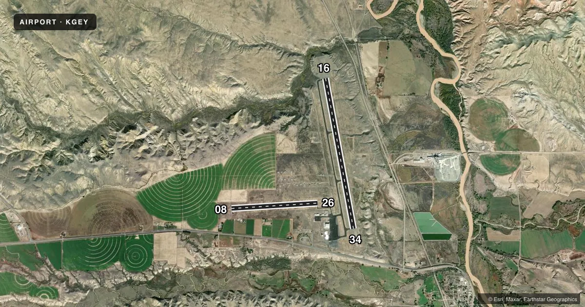
Runways & pattern
Full pagePattern entry · RWY 16
LEFT TRAFFIC| Runway | Heading (°M) | Length | Surface | Traffic |
|---|---|---|---|---|
| 16/34Favored | 159° / 339° | 7,003 ft | ASPH | Standard L |
| 08/26 | 76° / 256° | 3,953 ft | ASPH | Standard L |
Runway end performance
| End | TORA | TODA | ASDA | LDA | VGSI | Approach lights | Obstruction |
|---|---|---|---|---|---|---|---|
| 16 | — | — | — | — | PAPI 4-box left(3°) | — | — |
| 34 | — | — | — | — | PAPI 4-box left(3°) | — | — |
Declared distances in feet. TORA = takeoff run available, TODA = takeoff distance, ASDA = accelerate-stop, LDA = landing distance.
Airport sketch
Runways drawn to scale from FAA survey coordinates, rendered over satellite imagery. Not for navigation.
Approaches & charts
Services on the field
Fuel grades, oxygen, maintenance, ramp storage and lighting — as declared to the FAA by the airport operator.
Fuel & services
- Fuel
- 100LLA
- Oxygen (bottled)
- Not available
- Oxygen (bulk)
- Not available
- Airframe repair
- Major
- Power plant repair
- Major
Ramp & ground
- Transient storage
- Tie-down
- Hangar
- Landing fee
- No fee published
- Customs
- Not available
- Lighting schedule
- SEE RMK
- Beacon schedule
- SS-SR
- Beacon
- White / Green (civil land)(WG)
- Wind indicator
- Lighted
- Segmented circle
- Yes
Fuel & FBOs
Cheapest 100LL and Jet A on the field and nearby. Always confirm with the FBO before taxi.
Airport notes
Surface conditions, obstructions, local procedures, lighting outages and other notes published with each FAA cycle.
General notes
- TERRAIN 1066 FT ABV ARPT ELEV 4-5 MILES NORTH & NE OF ARPT.
- ANTELOPE ON & INVOF RY.
- FOR CD CTC SALT LAKE ARTCC AT 801-320-2568.
Lighting notes
- ACTVT MIRL RWY 16/34; PAPI RWY 16 & 34; REILS RWY 16 & 34 -CTAF.
Fuel notes
- 100LLAVLB H24 VIA CREDIT CARD.
- AFULL SVC ONLY. FONE AHD 307-680-4897 OR TEXT/CALL AMGR.
Other notes
- FOR AIRFRAME AND/OR POWERPLANT RPRS FONE 307-431-1464.
- PILOT SUPPLIED ROPES RQRD FOR TIE DOWNS.
VFR map & nearby airports
VFR sectional. Tap any ICAO chip to open that airport.
Key facts · KGEY
Answer card- ICAO
- KGEY
- Name
- SOUTH BIG HORN COUNTY
- Location
- GREYBULL, WYOMING
- Elevation
- 3,941.8 ft MSL
- Traffic pattern altitude
- 4,941.8 ft MSL (1,000 AGL)
- Control tower
- Non-towered (use CTAF)
- Total runways
- 2
- Longest runway
- 16/34 · 7,003 ft
- Published ILS approaches
- 0
- Published frequencies
- 1
- Magnetic variation
- 10°
- Current flight rules
- VFR
- Current wind
- 200° at 7 kt
- Favored runway now
- RWY 16
South Big Horn County Airport sits in Greybull, Wyoming. The field elevation is 3,941.8 ft MSL. It has two asphalt runways. The longest is 16/34 at 7,003 ft. Runway 08/26 is 3,953 ft. There is no control tower. CTAF is 122.9.
No ILS approaches are published here. Pattern altitude is not published, so plan on the standard 1,000 ft AGL for light piston traffic unless the current Chart Supplement says otherwise. The airport sits in a higher-elevation part of Wyoming. Terrain rises 1,066 ft above airport elevation 4 to 5 miles north and northeast of the field. That matters for climb performance and departure planning.
On the field, South Big Horn County Airport carries AVGAS 100LL. B & G Industries carries Jet A and Jet A Prist. The airport remarks also say 100LL is available 24 hours a day by credit card. Full service is available. Phone ahead or contact the airport manager before you count on it. Medium intensity runway lights are on runway 16/34. PAPI and REIL are installed on 16 and 34. REIL is controlled by CTAF. Antelope are on and near the runway, so keep your scan active on taxi, takeoff and landing.