METAR & TAF KCOD
Current METAR
Observed 11:56Z
KCOD 271156Z AUTO 00000KT 10SM CLR 17/12 A3008 RMK AO2 SLP123 70001 T01720122 10222 20172 55006 $
- Wind
- 000° @ 0 kt
- Visibility
- 10 SM
- Temp / Dew
- 17°C / 12°C
- Altimeter
- 30.08 inHg
- Clouds
- CLR
- Density alt
- 6,368 ft
- Ceiling
- Unlimited
- Rules
- VFR
Airport info & contacts
Manager on record, flight service, ARTCC, attendance schedule and pattern altitude — published by the FAA and refreshed every 28 days.
Location
- From city
- 2 NM SE
- VFR sectional
- GREAT FALLS
- ARTCC
- ZLC · SALT LAKE CITY
- NOTAM facility
- COD (NOTAM-D)
Airport manager
- Name
- AARON BUCK
- Phone
- 307-587-5096
- Address
- 2101 ROGER SEDAM DRIVE, SUITE 1, CODY WY 82414
Flight service · Hours
- FSS CPR
- CASPER1-800-WX-BRIEF
- Attendance
- 0500-2200
Frequencies
Tap any row to copy the frequency to your clipboard.
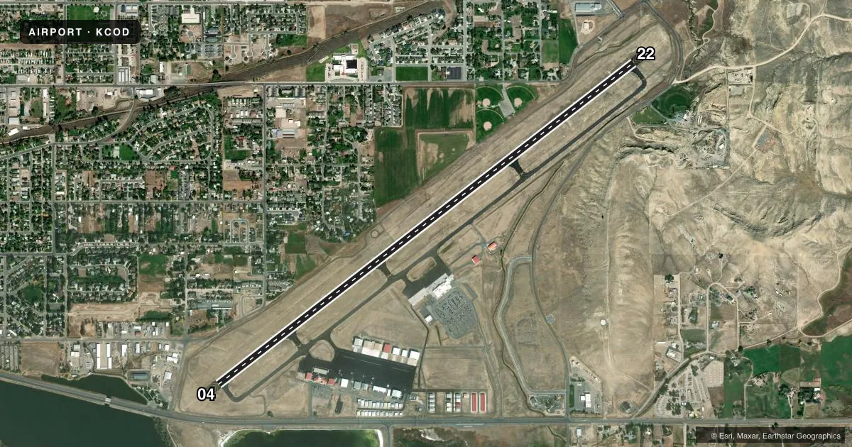
Runways & pattern
Full pagePattern entry · RWY 04
LEFT TRAFFICRunway end performance
| End | TORA | TODA | ASDA | LDA | VGSI | Approach lights | Obstruction |
|---|---|---|---|---|---|---|---|
| 04 | 8,268' | 8,268' | 7,868' | 7,178' | PAPI 4-box left(3.5°) | MALSF | 15', pole, 731' from thr, 240' R of cntrln, slope 35 |
| 22 | 8,268' | 8,268' | 7,578' | 7,178' | PAPI 4-box left(3°) | MALSR | 55', gnd, 2087' from thr, 404' R of cntrln, slope 34 |
Declared distances in feet. TORA = takeoff run available, TODA = takeoff distance, ASDA = accelerate-stop, LDA = landing distance.
Airport sketch
Runways drawn to scale from FAA survey coordinates, rendered over satellite imagery. Not for navigation.
Approaches & charts
Services on the field
Fuel grades, oxygen, maintenance, ramp storage and lighting — as declared to the FAA by the airport operator.
Fuel & services
- Fuel
- 100100LLAA+
- Oxygen (bottled)
- Not available
- Oxygen (bulk)
- High pressure
- Airframe repair
- Major
- Power plant repair
- Major
- Other services
- AFRT,AGRI,CHTR,INSTR,RNTL,SALES
Ramp & ground
- Transient storage
- Tie-down
- Hangar
- Landing fee
- Yes
- Customs
- Not available
- Lighting schedule
- SEE RMK
- Beacon schedule
- SS-SR
- Beacon
- White / Green (civil land)(WG)
- Wind indicator
- Lighted
- Segmented circle
- Yes
Fuel & FBOs
Cheapest 100LL and Jet A on the field and nearby. Always confirm with the FBO before taxi.
Airport notes
Surface conditions, obstructions, local procedures, lighting outages and other notes published with each FAA cycle.
General notes
- LOW LEVEL WATERFOWL ON LAKE 1/4 MILE 'SE' OF RY 4 THLD.
- CALL OUT AFTER HRS SVC FM CHOICE AVIATION IS 307-587-9262.
- AIRFIELD SFC CONDS ARE NOT MNTND BTWN HRS OF 2300 - 0500.
- COLD TEMPERATURE AIRPORT. ALTITUDE CORRECTION REQUIRED AT OR BELOW -9C.
- FOR CD IF UNA TO CTC ON FSS FREQ, CTC SALT LAKE ARTCC AT 801-320-2568.
Lighting notes
- ACTVT MALSF RWY 04; MALSR RWY 22; REIL 22; PAPI RWY 04 & 22; HIRL RWY 04/22 - CTAF.
Runway surface & condition
- 04/22PCR VALUE: 300/F/D/X/T
Approach & departure obstructions
- 04PAPI UNUSBL BYD 4.0 NM DUE TO RPDLY RSG TRRN N OF FINAL TO RWY 04
- 04+345 FT POLES ON HILL ON CNTRLN EXTDD.
- 22+84 FT POLES ON HILL ON CNTRLN EXTDD.
Other notes
- CLSD TO UNSKED ACR OPNS WITH MORE THAN 30 PSGR SEATS EXCP PPR CALL ARPT OPS 307-899-5096.
- LANDING FEE FOR ACFT OVER 9000 LBS
- CTC FBO 307-587-9262 OR ARPT 307-899-5096.
VFR map & nearby airports
VFR sectional. Tap any ICAO chip to open that airport.
Key facts · KCOD
Answer card- ICAO
- KCOD
- Name
- YELLOWSTONE RGNL
- Location
- CODY, WYOMING
- Elevation
- 5,102.3 ft MSL
- Traffic pattern altitude
- 6,102.3 ft MSL (1,000 AGL)
- Control tower
- Non-towered (use CTAF)
- Total runways
- 1
- Longest runway
- 04/22 · 8,268 ft
- Published ILS approaches
- 0
- Published frequencies
- 2
- Magnetic variation
- 11°
- Current flight rules
- VFR
- Current wind
- 000° at 0 kt
- Favored runway now
- –
Yellowstone Rgnl sits in Cody, Wyoming. Field elevation is 5,102.3 ft MSL. The airport has one runway, 04/22, which is 8,268 ft long. There is no control tower. CTAF and UNICOM are both 122.8. No ILS approaches are published here.
Pattern altitude is not published in the facts. Use the standard 1,000 ft AGL for light piston traffic unless the current Chart Supplement says otherwise. This is a cold temperature airport. Altitude correction is required at or below minus 9 degrees Celsius. Surface conditions are not maintained between 2300 and 0500, so plan accordingly if you are arriving late.
Two on-field FBOs are listed. Ascension FBO carries 100LL, Jet A and Jet A Prist. Beacon Air Group carries 100LL and Jet A. For out of hours service, the published contact is Choice Aviation at 307-587-9262. If you need clearance delivery and cannot reach flight service, contact Salt Lake ARTCC. The field also has published lighting notes for runway 04 and 22. It also has terrain and obstacle items near both runway ends. Check those before a night or low-vis arrival. The runway has a published PCN of 300/F/D/X/T.