METAR & TAF KRED
KRED does not publish a METAR.
Showing the nearest reporting station: KPOY (POWELL MUNI) · 27.4 NM away. Conditions at KRED may differ.
METAR · KPOY
Observed 06:30Z
KPOY 270630Z AUTO 19003KT CLR 23/07 A3008 RMK AO2 PWINO
- Wind
- 190° @ 3 kt
- Visibility
- —
- Temp / Dew
- 23°C / 7°C
- Altimeter
- 30.08 inHg
- Clouds
- CLR
- Density alt
- 7,906 ft
- Ceiling
- Unlimited
- Rules
- VFR
Airport info & contacts
Manager on record, flight service, ARTCC, attendance schedule and pattern altitude — published by the FAA and refreshed every 28 days.
Location
- From city
- 1 NM NW
- VFR sectional
- GREAT FALLS
- ARTCC
- ZLC · SALT LAKE CITY
- NOTAM facility
- GTF (NOTAM-D)
Airport manager
- Name
- BO EWALD
- Phone
- 406-425-1591
- Address
- PO BOX 887, RED LODGE MT 59068
Flight service · Hours
- FSS GTF
- GREAT FALLS1-800-WX-BRIEF
- Attendance
- Unattended
Frequencies
Tap any row to copy the frequency to your clipboard.
Runways & pattern
Full pagePattern entry · RWY 16
LEFT TRAFFICRunway end performance
| End | TORA | TODA | ASDA | LDA | VGSI | Approach lights | Obstruction |
|---|---|---|---|---|---|---|---|
| 16 | — | — | — | — | VASI 2-box left(3°) | — | 14', tree, 408' from thr, 0' R of cntrln, slope 14 |
| 34 | — | — | — | — | — | — | 10', road, 288' from thr, 50' R of cntrln, slope 8 |
Declared distances in feet. TORA = takeoff run available, TODA = takeoff distance, ASDA = accelerate-stop, LDA = landing distance.
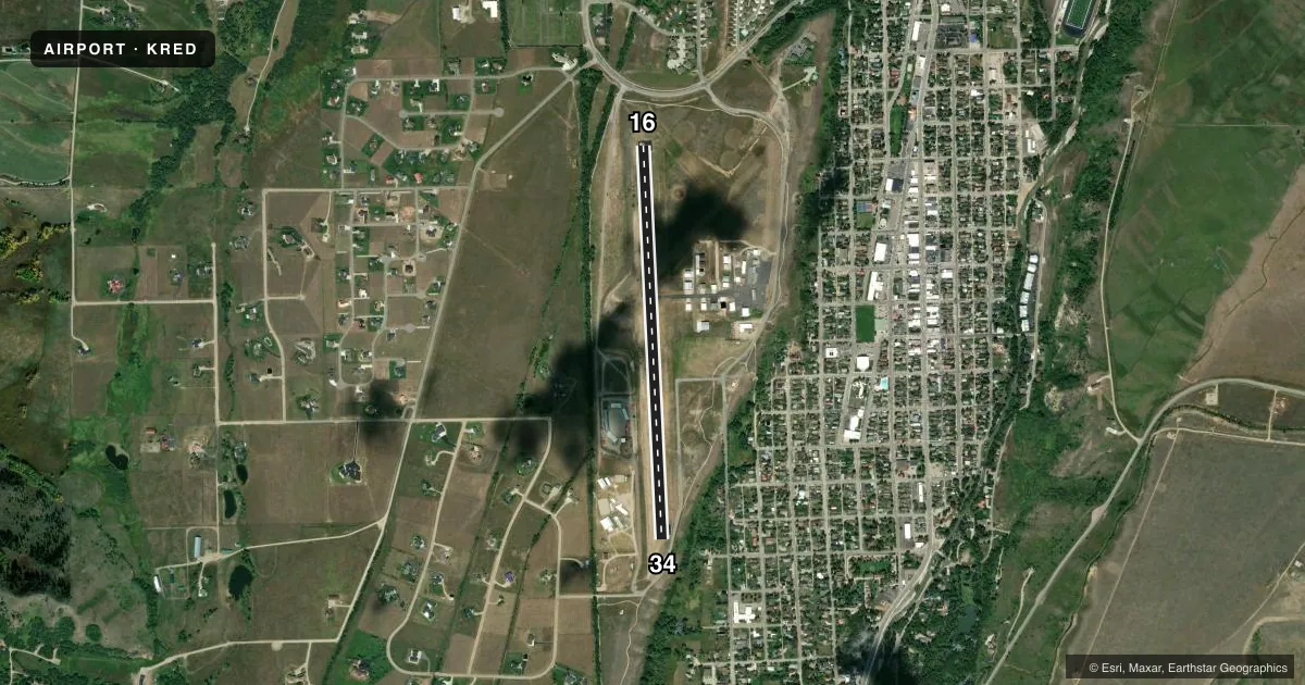
Airport sketch
Runways drawn to scale from FAA survey coordinates, rendered over satellite imagery. Not for navigation.
Approaches & charts
Services on the field
Fuel grades, oxygen, maintenance, ramp storage and lighting — as declared to the FAA by the airport operator.
Fuel & services
- Fuel
- 100LL
- Other services
- INSTR
Ramp & ground
- Transient storage
- Tie-down
- Landing fee
- No fee published
- Customs
- Not available
- Lighting schedule
- SEE RMK
- Beacon schedule
- SS-SR
- Beacon
- White / Green (civil land)(WG)
- Wind indicator
- Lighted
- Segmented circle
- Yes
Fuel & FBOs
Cheapest 100LL and Jet A on the field and nearby. Always confirm with the FBO before taxi.
Airport notes
Surface conditions, obstructions, local procedures, lighting outages and other notes published with each FAA cycle.
General notes
- WILDLIFE ON & INVOF ARPT.
- AUTOMATED UNICOM: 2 CLICKS ON 122.725.
- FOR CD CTC SALT LAKE ARTCC AT 801-320-2568.
- COND UNMNT; SEE HTTPS://WEATHERCAMS.FAA.GOV OR FOR CURRENT RWY COND - AMGR.
- GRASS STRIP OPS; FLY STD TFC PAT ALT; LMT OPS.
Lighting notes
- ACTVT VASI 16; MIRL RWY 16/34 - CTAF.
Fuel notes
- 100LLH24 CREDIT CARD; AVBLTY - 715-781-7054.
Runway surface & condition
- 16/34NOISE ABATEMENT PROC IN EFCT; PILOTS REQSTD TO; RWY 16 ARR FLY DNWND AT TFC PAT ALT OVR BLUFF E OF DOWNTOWN & WHEN SAFE & PRACTICAL FLY HIGH ANGLE FINAL APP SLP; RWY 34 DEP, MNVR ON UPWIND TO W OF RESIDENTIAL AREA N OF ARPT AS SOON AS SAFE & PRACTICAL; RWY 34 ARR, FLY DNWND W OF RESIDENTIAL AREA W. CROSSWIND GRASS STRIPS; LIMIT OPNS TO/FROM XWIND GRASS STRIPS & FLY STD TFC PATTERNS AT TPA TO MINIMIZE IMPACTS UPON CITY DOWNTOWN & RESIDENTIAL AREAS IMMEDIATELY E OF ARPT.
Approach & departure obstructions
- 34+4 FT FENCE & +10 FT ROAD 100-110 FT RIGHT X CNTRLN 288 FT FM THR. -400 FT TRRN DROPOFF 150 FT R.
- 16FADED; PTNS MISG.
- 34FADED.
Other notes
- TIE-DOWN ROPES/STRAPS MUST BE SUPPLIED BY AIRCRAFT OPERATOR.
- 16/34EDGE CRACKING & ERODING; LOOSE SFC GRVL.
VFR map & nearby airports
VFR sectional. Tap any ICAO chip to open that airport.
Key facts · KRED
Answer card- ICAO
- KRED
- Name
- RED LODGE
- Location
- RED LODGE, MONTANA
- Elevation
- 5,762 ft MSL
- Traffic pattern altitude
- 6,762 ft MSL (1,000 AGL)
- Control tower
- Non-towered (use CTAF)
- Total runways
- 1
- Longest runway
- 16/34 · 4,000 ft
- Published ILS approaches
- 0
- Published frequencies
- 1
- Magnetic variation
- 15°
- Current flight rules
- VFR
- Current wind
- 190° at 3 kt
- Favored runway now
- RWY 16
Red Lodge Airport sits in Red Lodge, Montana. The field elevation is 5,762 ft MSL. It has one runway. Runway 16/34 is 4,000 ft long with an asphalt surface. There is no control tower. CTAF is 122.9.
No ILS approaches are published here. The pattern altitude is not published, so use the standard 1,000 ft AGL for light piston operations unless the current Chart Supplement says otherwise. Ray Judd Petroleum is on the field. It carries 100LL. 100LL is also available 24 hours by credit card. The runway lighting for 16/34 is controlled by CTAF. A VASI is available for runway 16.
This is a high-elevation field, so density altitude can matter a lot on warm days. Wildlife is reported on and near the airport. Published remarks also say runway condition is unmonitored, so check the current FAA Chart Supplement or contact the airport manager before you go. Noise abatement is in effect. For runway 16 arrivals, plan to stay downwind at traffic pattern altitude over the bluff east of downtown when safe and practical. For runway 34 departures, move west of the residential area north of the airport as soon as practical. Runway 16 and 34 markings are faded. Some portions of runway 16 markings are missing. There is also edge cracking, erosion and loose gravel on the runway surface.