METAR & TAF 6S8
Current METAR
Observed 12:35Z
K6S8 271235Z AUTO 25004KT 10SM CLR 20/17 A2999 RMK A01
- Wind
- 250° @ 4 kt
- Visibility
- 10 SM
- Temp / Dew
- 20°C / 17°C
- Altimeter
- 29.99 inHg
- Clouds
- CLR
- Density alt
- 4,906 ft
- Ceiling
- Unlimited
- Rules
- VFR
Airport info & contacts
Manager on record, flight service, ARTCC, attendance schedule and pattern altitude — published by the FAA and refreshed every 28 days.
Location
- From city
- 2 NM N
- VFR sectional
- BILLINGS
- ARTCC
- ZLC · SALT LAKE CITY
- NOTAM facility
- GTF (NOTAM-D)
Airport manager
- Name
- AIRPORT BOARD
- Phone
- 406-628-0172
- Address
- PO BOX 242, LAUREL MT 59044
Flight service · Hours
- FSS GTF
- GREAT FALLS1-800-WX-BRIEF
- Attendance
- MON-FRI · 0800-1700
- SAT-SUN · INTERMITTANT
Frequencies
Tap any row to copy the frequency to your clipboard.
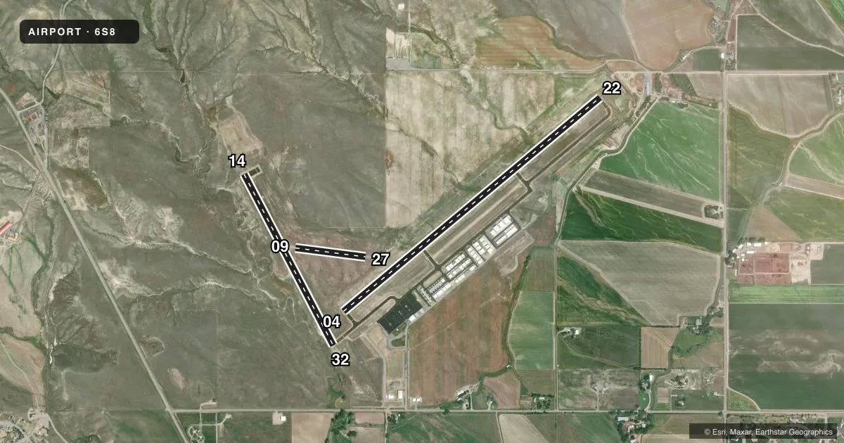
Runways & pattern
Full pagePattern entry · RWY 22
LEFT TRAFFIC| Runway | Heading (°M) | Length | Surface | Traffic |
|---|---|---|---|---|
| 04/22Favored | 36° / 216° | 5,199 ft | ASPH | Standard L |
| 14/32 | 138° / 318° | 3,002 ft | ASPH | Standard L |
| 09/27 | 84° / 264° | 1,100 ft | TURF | Standard L |
Runway end performance
| End | TORA | TODA | ASDA | LDA | VGSI | Approach lights | Obstruction |
|---|---|---|---|---|---|---|---|
| 04 | — | — | — | — | PAPI 2-box left(3°) | — | — |
| 22 | — | — | — | — | PAPI 2-box left(3°) | — | — |
| 14 | — | — | — | — | PAPI 2-box left(4°) | — | — |
| 32 | — | — | — | — | PAPI 2-box left(3°) | — | — |
Declared distances in feet. TORA = takeoff run available, TODA = takeoff distance, ASDA = accelerate-stop, LDA = landing distance.
Airport sketch
Runways drawn to scale from FAA survey coordinates, rendered over satellite imagery. Not for navigation.
Approaches & charts
Services on the field
Fuel grades, oxygen, maintenance, ramp storage and lighting — as declared to the FAA by the airport operator.
Fuel & services
- Fuel
- 100LLA
- Oxygen (bottled)
- Not available
- Oxygen (bulk)
- Not available
- Airframe repair
- Minor
- Power plant repair
- Minor
- Other services
- CHTR,INSTR,SALES
Ramp & ground
- Transient storage
- Tie-down
- Hangar
- Landing fee
- No fee published
- Customs
- Not available
- Lighting schedule
- SEE RMK
- Beacon schedule
- SS-SR
- Beacon
- White / Green (civil land)(WG)
- Wind indicator
- Lighted
- Segmented circle
- Yes
Fuel & FBOs
Cheapest 100LL and Jet A on the field and nearby. Always confirm with the FBO before taxi.
Airport notes
Surface conditions, obstructions, local procedures, lighting outages and other notes published with each FAA cycle.
General notes
- NUMEROUS DEER AND ANTELOPE ON AND INVOF OF RY.
- RY 09/27 NOT MAINTAINED DURG WINTER.
- INTMT SNOW REMOVAL- BE ALERT DURING WINTER MONTHS.
- FOR CD CTC BILLINGS APCH AT 406-255-2798
Lighting notes
- ACTVT PAPI RWY 04 & 22 & 14 & 32; MIRL RWY 04/22 & 14/32 - CTAF.
Approach & departure obstructions
- 0909/27 MARKER CONES FULL RY LENGTH.
Other notes
- AUTOMATED UNICOM
VFR map & nearby airports
VFR sectional. Tap any ICAO chip to open that airport.
Key facts · 6S8
Answer card- ICAO
- 6S8
- Name
- LAUREL MUNI
- Location
- LAUREL, MONTANA
- Elevation
- 3,542.6 ft MSL
- Traffic pattern altitude
- 4,542.6 ft MSL (1,000 AGL)
- Control tower
- Non-towered (use CTAF)
- Total runways
- 3
- Longest runway
- 04/22 · 5,199 ft
- Published ILS approaches
- 0
- Published frequencies
- 5
- Magnetic variation
- 14°
- Current flight rules
- VFR
- Current wind
- 250° at 4 kt
- Favored runway now
- RWY 22
Laurel Muni sits in Laurel, Montana at 3,542.6 ft MSL. It has three runways. The longest is 04/22 at 5,199 ft. Runways 14/32 and 04/22 are asphalt. Runway 09/27 is turf and is not maintained during winter. There is no control tower. Pattern altitude is not published, so use the standard 1,000 ft AGL for light piston aircraft unless the current Chart Supplement says otherwise.
No ILS approaches are published here. CTAF and UNICOM are both 123.05. Billings Approach handles IFR work on 119.2, 120.5 and 284.6. For clearance delivery, contact Billings Approach at 406-255-2798. PAPI is available on runways 04, 22, 14 and 32. Medium intensity runway lights are on 04/22 and 14/32. They are controlled by CTAF.
This is a higher-elevation field, so performance planning matters. Expect thinner air than a lowland strip. The published remarks also call out deer and antelope on and near the runway. Winter operations need extra attention because intermediate snow removal is conducted. Runway 09/27 has marker cones along the full length. There are no on-field FBOs listed, so verify services with the airport operator or call the field on CTAF before arrival.