METAR & TAF 80S
80S does not publish a METAR.
Showing the nearest reporting station: KBIL (BILLINGS LOGAN INTL) · 34.5 NM away. Conditions at 80S may differ.
METAR · KBIL
Observed 16:53Z
KBIL 261653Z VRB06KT 10SM FEW160 FEW250 31/09 A3003 RMK AO2 SLP126 HZ DSNT ALQDS T03060094
- Wind
- VAR @ 6 kt
- Visibility
- 10 SM
- Temp / Dew
- 31°C / 9°C
- Altimeter
- 30.03 inHg
- Clouds
- FEW
- Density alt
- 6,138 ft
- Ceiling
- Unlimited
- Rules
- VFR
Airport info & contacts
Manager on record, flight service, ARTCC, attendance schedule and pattern altitude — published by the FAA and refreshed every 28 days.
Location
- From city
- 2 NM NW
- VFR sectional
- BILLINGS
- ARTCC
- ZLC · SALT LAKE CITY
- NOTAM facility
- GTF (NOTAM-D)
Airport manager
- Name
- MDT AERONAUTICS
- Phone
- 406-444-2506
- Address
- BOX 200507, HELENA MT 59620-0507
Flight service · Hours
- FSS GTF
- GREAT FALLS1-800-WX-BRIEF
- Attendance
- Unattended
Frequencies
Tap any row to copy the frequency to your clipboard.
Runways & pattern
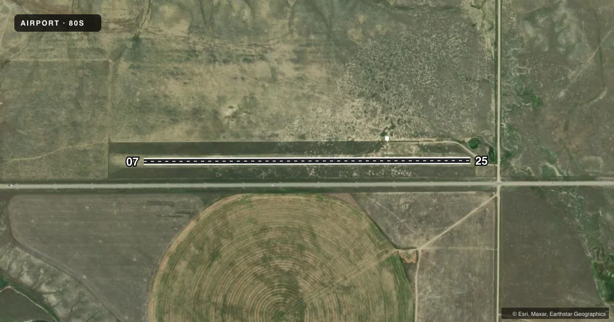
Full pagePattern entry · RWY 07
LEFT TRAFFICAirport sketch
Runways drawn to scale from FAA survey coordinates, rendered over satellite imagery. Not for navigation.
Approaches & charts
Services on the field
Fuel grades, oxygen, maintenance, ramp storage and lighting — as declared to the FAA by the airport operator.
Fuel & services
- Fuel
- Not available
- Oxygen (bottled)
- Not available
- Oxygen (bulk)
- Not available
- Airframe repair
- Not available
- Power plant repair
- Not available
Ramp & ground
- Transient storage
- Tie-down
- Landing fee
- No fee published
- Wind indicator
- Yes
- Segmented circle
- Yes
Fuel & FBOs
Cheapest 100LL and Jet A on the field and nearby. Always confirm with the FBO before taxi.
Airport notes
Surface conditions, obstructions, local procedures, lighting outages and other notes published with each FAA cycle.
General notes
- NO SNOW REMOVAL.
- FOR CD CTC BILLINGS APCH AT 406-255-2798
- CELL TWR 0.5 MI ESE OF ARPT.
Approach & departure obstructions
- 0707/25 MKD WITH CONES FULL RY LENGTH.
Other notes
- 07/25VERY MUDDY WHEN WET; FEW GOPHER HOLES.
VFR map & nearby airports
VFR sectional. Tap any ICAO chip to open that airport.
Key facts · 80S
Answer card- ICAO
- 80S
- Name
- LAVINA
- Location
- LAVINA, MONTANA
- Elevation
- 3,512 ft MSL
- Traffic pattern altitude
- 4,512 ft MSL (1,000 AGL)
- Control tower
- Non-towered (use CTAF)
- Total runways
- 1
- Longest runway
- 07/25 · 3,460 ft
- Published ILS approaches
- 0
- Published frequencies
- 1
- Magnetic variation
- 15°
- Current flight rules
- VFR
- Current wind
- 000° at 6 kt
- Favored runway now
- RWY 07
Lavina Airport sits in Lavina, Montana. Field elevation is 3,512 ft MSL. The airport has one runway. Runway 07/25 is 3,460 ft long and surfaced with turf. The runway headings are magnetic 90° and 270°. No control tower is published, so use CTAF 122.9 and keep your scan tight in the pattern.
No ILS approaches are published here. Pattern altitude is not published in the facts, so verify the current Chart Supplement before you fly. The airport is in a high-plains setting at elevation, so performance planning matters. Expect density altitude to be a factor on warm days. The published remarks also call out a cell tower about 0.5 mile east-southeast of the airport. Runway 07/25 is marked with cones along the full length. The surface is reported to get very muddy when wet, with a few gopher holes. No snow removal is provided.
There are no on-field FBOs listed. Check with the airport operator or the FBO directly by phone before arrival if you need fuel or local services. For clearance delivery, contact Billings Approach at 406-255-2798.