METAR & TAF 8U0
8U0 does not publish a METAR.
Showing the nearest reporting station: KBIL (BILLINGS LOGAN INTL) · 41.2 NM away. Conditions at 8U0 may differ.
METAR · KBIL
Observed 05:53Z
KBIL 270553Z 31010G27KT 10SM -RA FEW035 SCT060 BKN130 BKN200 26/13 A2999 RMK AO2 PK WND 28035/0533 WSHFT 0527 RAB46 SLP109 OCNL LTGICCG CB DSNT W-NW P0000 60001 T02610133 10339 20233 55015
- Wind
- 310° @ 10G27 kt
- Visibility
- 10 SM
- Temp / Dew
- 26°C / 13°C
- Altimeter
- 29.99 inHg
- Clouds
- BKN
- Density alt
- 5,808 ft
- Ceiling
- 13,000 ft AGL
- Rules
- VFR
Airport info & contacts
Manager on record, flight service, ARTCC, attendance schedule and pattern altitude — published by the FAA and refreshed every 28 days.
Location
- From city
- 1 NM S
- VFR sectional
- GREAT FALLS
- ARTCC
- ZLC · SALT LAKE CITY
- NOTAM facility
- GTF (NOTAM-D)
Airport manager
- Name
- MDT AERONAUTICS
- Phone
- 406-444-2506
- Address
- BOX 200507, HELENA MT 59620-0507
Flight service · Hours
- FSS GTF
- GREAT FALLS1-800-WX-BRIEF
- Attendance
- Unattended
Frequencies
Tap any row to copy the frequency to your clipboard.
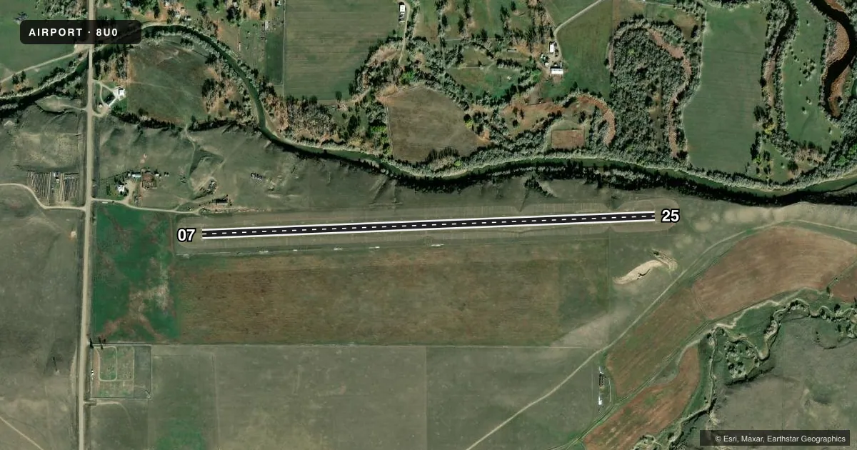
Runways & pattern
Full pagePattern entry · RWY 25
LEFT TRAFFICAirport sketch
Runways drawn to scale from FAA survey coordinates, rendered over satellite imagery. Not for navigation.
Approaches & charts
Services on the field
Fuel grades, oxygen, maintenance, ramp storage and lighting — as declared to the FAA by the airport operator.
Fuel & services
- Fuel
- Not available
Ramp & ground
- Transient storage
- Tie-down
- Landing fee
- No fee published
- Customs
- Not available
- Wind indicator
- Yes
- Segmented circle
- Yes
Fuel & FBOs
Cheapest 100LL and Jet A on the field and nearby. Always confirm with the FBO before taxi.
Airport notes
Surface conditions, obstructions, local procedures, lighting outages and other notes published with each FAA cycle.
General notes
- NO SNOW REMOVAL.
- FOR CD CTC SALT LAKE ARTCC AT 801-320-2568.
- +300 FT HILL 0.75 MI SE FM RWY END.
Approach & departure obstructions
- 07WHITE CONES FULL LEN.
- 25WHITE CONES FULL LEN.
Other notes
- 07/25SFC COND ROUGH, GOPHER HOLES.
VFR map & nearby airports
VFR sectional. Tap any ICAO chip to open that airport.
Key facts · 8U0
Answer card- ICAO
- 8U0
- Name
- RYEGATE
- Location
- RYEGATE, MONTANA
- Elevation
- 3,689 ft MSL
- Traffic pattern altitude
- 4,689 ft MSL (1,000 AGL)
- Control tower
- Non-towered (use CTAF)
- Total runways
- 1
- Longest runway
- 07/25 · 3,440 ft
- Published ILS approaches
- 0
- Published frequencies
- 1
- Magnetic variation
- 15°
- Current flight rules
- VFR
- Current wind
- 310° at 10 kt
- Favored runway now
- RWY 25
8U0 sits at Ryegate in central Montana. Field elevation is 3,689 ft MSL. The airport has one runway. Runway 07/25 is 3,440 ft long and turf. The runway headings are 88° and 268° magnetic. There is no control tower. CTAF is 122.9.
No ILS approaches are published here. Pattern altitude is not published, so use standard traffic pattern planning unless the current Chart Supplement says otherwise. The published remarks matter here. White cones mark the full length of both runway directions. The runway surface is rough with gopher holes. No snow removal is provided. There is also a hill more than 300 ft high about 0.75 miles southeast of the runway end, so keep that in mind on departure and arrival.
There are no on-field FBOs listed. Plan fuel and services accordingly before you go. For clearance delivery, contact Salt Lake ARTCC at 801-320-2568. This is a high-elevation turf strip with no tower and no published ILS. A first-time pilot should brief the terrain, runway condition and density altitude before arrival. Check the current FAA Chart Supplement for any updates before flying in.