METAR & TAF KHWQ
KHWQ does not publish a METAR.
Showing the nearest reporting station: KLWT (LEWISTOWN MUNI) · 39.4 NM away. Conditions at KHWQ may differ.
METAR · KLWT
Observed 16:54Z
KLWT 241654Z AUTO 27010KT 10SM CLR 30/11 A3000 RMK AO2 SLP113 T03000111
- Wind
- 270° @ 10 kt
- Visibility
- 10 SM
- Temp / Dew
- 30°C / 11°C
- Altimeter
- 30.00 inHg
- Clouds
- CLR
- Density alt
- 7,048 ft
- Ceiling
- Unlimited
- Rules
- VFR
Airport info & contacts
Manager on record, flight service, ARTCC, attendance schedule and pattern altitude — published by the FAA and refreshed every 28 days.
Location
- From city
- 2 NM NW
- VFR sectional
- GREAT FALLS
- ARTCC
- ZLC · SALT LAKE CITY
- NOTAM facility
- GTF (NOTAM-D)
Airport manager
- Name
- LYNN DALE
- Phone
- (406) 632 5662
- Address
- BOX 1903, HARLOWTON MT 59036
Flight service · Hours
- FSS GTF
- GREAT FALLS1-800-WX-BRIEF
- Attendance
- Unattended
Frequencies
Tap any row to copy the frequency to your clipboard.
Runways & pattern
Full pagePattern entry · RWY 27
LEFT TRAFFICRunway end performance
| End | TORA | TODA | ASDA | LDA | VGSI | Approach lights | Obstruction |
|---|---|---|---|---|---|---|---|
| 09 | — | — | — | — | — | — | 19', tree, 410' from thr, 30' R of cntrln, slope 11 |
| 27 | — | — | — | — | PAPI 2-box left(3°) | — | — |
Declared distances in feet. TORA = takeoff run available, TODA = takeoff distance, ASDA = accelerate-stop, LDA = landing distance.
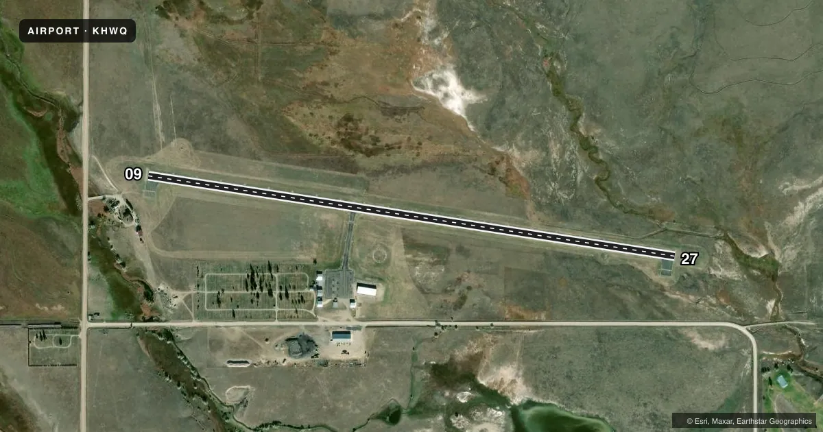
Airport sketch
Runways drawn to scale from FAA survey coordinates, rendered over satellite imagery. Not for navigation.
Approaches & charts
Services on the field
Fuel grades, oxygen, maintenance, ramp storage and lighting — as declared to the FAA by the airport operator.
Fuel & services
- Fuel
- Not available
- Oxygen (bottled)
- Not available
- Oxygen (bulk)
- Not available
- Airframe repair
- Not available
- Power plant repair
- Not available
Ramp & ground
- Transient storage
- Tie-down
- Hangar
- Landing fee
- No fee published
- Customs
- Not available
- Lighting schedule
- SEE RMK
- Beacon schedule
- SS-SR
- Beacon
- White / Green (civil land)(WG)
- Wind indicator
- Lighted
- Segmented circle
- Yes
Fuel & FBOs
Cheapest 100LL and Jet A on the field and nearby. Always confirm with the FBO before taxi.
Airport notes
Surface conditions, obstructions, local procedures, lighting outages and other notes published with each FAA cycle.
General notes
- DEER ON & INVOF RY; ESPECIALLY DURING NIGHTIME HOURS.
- FOR CD IF UNA TO CTC ON FSS FREQ, CTC SALT LAKE ARTCC AT 801-320-2568.
Lighting notes
- ACTVT MIRL RY 09/27 & PAPI RY 27 - CTAF.
VFR map & nearby airports
VFR sectional. Tap any ICAO chip to open that airport.
Key facts · KHWQ
Answer card- ICAO
- KHWQ
- Name
- WHEATLAND COUNTY AT HARLOWTON
- Location
- HARLOWTON, MONTANA
- Elevation
- 4,311.9 ft MSL
- Traffic pattern altitude
- 5,311.9 ft MSL (1,000 AGL)
- Control tower
- Non-towered (use CTAF)
- Total runways
- 1
- Longest runway
- 09/27 · 4,200 ft
- Published ILS approaches
- 0
- Published frequencies
- 1
- Magnetic variation
- 11°
- Current flight rules
- VFR
- Current wind
- 270° at 10 kt
- Favored runway now
- RWY 27
Wheatland County at Harlowton sits in Harlowton, Montana. Field elevation is 4,311.9 ft MSL. The airport has one runway. Runway 09/27 is 4,200 ft of asphalt, so that is the longest runway here. There is no control tower. CTAF is 122.9.
No ILS approaches are published for KHWQ. The pattern altitude is not published, so use the standard 1,000 ft AGL for light piston operations unless current published guidance says otherwise. That puts the common traffic pattern reference at about 5,311.9 ft MSL based on the field elevation. Check the current FAA Chart Supplement before you go.
Published remarks matter here. Deer are on and near the runway, especially at night. That is a real factor for arrival and departure planning. Medium intensity runway lights are on runway 09/27. The PAPI for runway 27 is also activated by CTAF. There are no on-field FBOs listed, so verify services with the airport operator or call the FBO directly by phone before arrival. If you need clearance delivery help and cannot reach Flight Service, contact Salt Lake Air Route Traffic Control Center at 801-320-2568.