METAR & TAF KLWT
Current METAR
Observed 16:54Z
KLWT 241654Z AUTO 27010KT 10SM CLR 30/11 A3000 RMK AO2 SLP113 T03000111
- Wind
- 270° @ 10 kt
- Visibility
- 10 SM
- Temp / Dew
- 30°C / 11°C
- Altimeter
- 30.00 inHg
- Clouds
- CLR
- Density alt
- 6,872 ft
- Ceiling
- Unlimited
- Rules
- VFR
Airport info & contacts
Manager on record, flight service, ARTCC, attendance schedule and pattern altitude — published by the FAA and refreshed every 28 days.
Location
- From city
- 2 NM SW
- VFR sectional
- GREAT FALLS
- ARTCC
- ZLC · SALT LAKE CITY
- NOTAM facility
- LWT (NOTAM-D)
Airport manager
- Name
- BRYON ARMOUR
- Phone
- (406) 535-3264
- Address
- P.O. BOX 343, 190 TERMINAL DRIVE, LEWISTOWN MT 59457
Flight service · Hours
- FSS GTF
- GREAT FALLS1-800-WX-BRIEF
- Attendance
- MON-FRI · 0800-1700
Frequencies
Tap any row to copy the frequency to your clipboard.
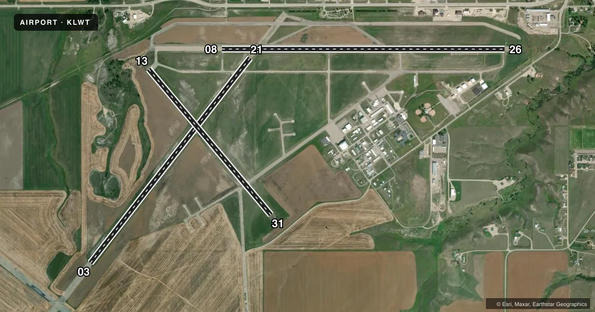
Runways & pattern
Full pagePattern entry · RWY 26
LEFT TRAFFIC| Runway | Heading (°M) | Length | Surface | Traffic |
|---|---|---|---|---|
| 08/26Favored | 79° / 259° | 6,100 ft | ASPH | Standard L |
| 03/21 | 27° / 207° | 5,600 ft | ASPH-GRVL | Standard L |
| 13/31 | 129° / 309° | 4,102 ft | ASPH | Standard L |
Runway end performance
| End | TORA | TODA | ASDA | LDA | VGSI | Approach lights | Obstruction |
|---|---|---|---|---|---|---|---|
| 08 | 6,100' | 6,100' | 6,100' | 6,100' | PAPI 2-box left(3°) | — | — |
| 26 | 6,100' | 6,100' | 6,100' | 6,100' | VASI 4-box left(3°) | — | — |
| 03 | 5,600' | 5,600' | 5,600' | 5,600' | — | — | — |
| 21 | 5,600' | 5,600' | 5,600' | 5,600' | — | — | — |
Declared distances in feet. TORA = takeoff run available, TODA = takeoff distance, ASDA = accelerate-stop, LDA = landing distance.
Airport sketch
Runways drawn to scale from FAA survey coordinates, rendered over satellite imagery. Not for navigation.
Approaches & charts
Services on the field
Fuel grades, oxygen, maintenance, ramp storage and lighting — as declared to the FAA by the airport operator.
Fuel & services
- Fuel
- 100100LLA
- Oxygen (bottled)
- Not available
- Oxygen (bulk)
- Not available
- Airframe repair
- Major
- Power plant repair
- Major
- Other services
- AGRI,AVNCS,CHTR,INSTR,RNTL,SALES
Ramp & ground
- Transient storage
- Tie-down
- Hangar
- Landing fee
- No fee published
- Customs
- Not available
- Lighting schedule
- SEE RMK
- Beacon schedule
- SS-SR
- Beacon
- White / Green (civil land)(WG)
- Wind indicator
- Lighted
- Segmented circle
- Yes
Fuel & FBOs
Cheapest 100LL and Jet A on the field and nearby. Always confirm with the FBO before taxi.
Airport notes
Surface conditions, obstructions, local procedures, lighting outages and other notes published with each FAA cycle.
General notes
- ALL TWYS HAVE REFLECTORS EXCEPT TWY C, E, AND HALF OF A, WHICH ARE LGTD.
- RY 03/21 DAY USE ONLY.
- RWY 03/21 NOT MNTND IN WINTER; RWY 13/31 PLOWED AS NEEDED.
- ARPT SFC CONDS NOT MNTD 1700-0500.
- BIRDS ON AND INVOF AIRPORT.
- FOR CD IF UNA TO CTC ON FSS FREQ, CTC SALT LAKE ARTCC AT 801-320-2568.
Lighting notes
- ACTVT REIL RWYS 08 & 26; PAPI RWY 08; VASI RWY 26; MIRL RWYS 08/26 & 13/31; - CTAF.
Approach & departure obstructions
- 03RWY 03/21 MRKGS FADED.
Other notes
- THIS AIRPORT HAS BEEN SURVEYED BY THE NATIONAL GEODETIC SURVEY.
- PVD ALL ULTRALIGHTS FLY AT 300'AGL OR LESS WHEN IN CTLZ; AND MAINT A DSTC OF 500' OR GREATER FM THE CL OF ANY ACTV TXY/RWY, EXTD 2 MI FM THE ARPT & TO THE GND ON ANY ACTV RWY; ALL ULTRALIGHTS OPER OFF THE CLSD TXY TO RWY 11/29 ON S END. A LTR OF AGRMT IS FORMULATED BTN ARPT MGR & ZLC.
- MANAGEROR CALL 406-350-3264.
- 03/21RWY 03/21 ASPH SPALLING.
- 03/21LOOSE GRAVEL SFC.
VFR map & nearby airports
VFR sectional. Tap any ICAO chip to open that airport.
Key facts · KLWT
Answer card- ICAO
- KLWT
- Name
- LEWISTOWN MUNI
- Location
- LEWISTOWN, MONTANA
- Elevation
- 4,170.4 ft MSL
- Traffic pattern altitude
- 5,170.4 ft MSL (1,000 AGL)
- Control tower
- Non-towered (use CTAF)
- Total runways
- 3
- Longest runway
- 08/26 · 6,100 ft
- Published ILS approaches
- 0
- Published frequencies
- 2
- Magnetic variation
- 11°
- Current flight rules
- VFR
- Current wind
- 270° at 10 kt
- Favored runway now
- RWY 26
Lewistown Muni is in Lewistown, Montana. The field elevation is 4,170.4 ft MSL. It has three runways. The longest is runway 08/26 at 6,100 ft. This is a non-towered field. CTAF and UNICOM are both 123.0. No ILS approaches are published here.
Pattern altitude is not published. Use 1,000 ft AGL for light piston operations unless the current Chart Supplement says otherwise. That puts the standard pattern around 5,170 ft MSL at this field. Skyline Aviation is on the field. It carries AVGAS 100LL, Jet A and Jet A Prist. Call (406) 538-8150 for current service details before you go.
The airport sits in central Montana at higher elevation. Expect performance to matter, especially on warm days. Runway 03/21 is day use only. It is not maintained in winter. The remarks also note faded markings and loose gravel on 03/21, so check the surface before you plan to use it. Runway 13/31 is plowed as needed. Taxiway lighting is limited in places. Runway 08 has REILs and a PAPI. Runway 26 has REILs and a VASI. Airport surface conditions are not maintained from 1700 to 0500. Check the current Chart Supplement for any local operating notes before arrival.