METAR & TAF 5U0
5U0 does not publish a METAR.
Showing the nearest reporting station: KLWT (LEWISTOWN MUNI) · 25.3 NM away. Conditions at 5U0 may differ.
METAR · KLWT
Observed 16:54Z
KLWT 241654Z AUTO 27010KT 10SM CLR 30/11 A3000 RMK AO2 SLP113 T03000111
- Wind
- 270° @ 10 kt
- Visibility
- 10 SM
- Temp / Dew
- 30°C / 11°C
- Altimeter
- 30.00 inHg
- Clouds
- CLR
- Density alt
- 6,157 ft
- Ceiling
- Unlimited
- Rules
- VFR
Airport info & contacts
Manager on record, flight service, ARTCC, attendance schedule and pattern altitude — published by the FAA and refreshed every 28 days.
Location
- From city
- 0 NM S
- VFR sectional
- GREAT FALLS
- ARTCC
- ZLC · SALT LAKE CITY
- NOTAM facility
- GTF (NOTAM-D)
Airport manager
- Name
- CURTIS HERSHBERGER
- Phone
- 406-899-9310
- Address
- 801 N. BAIN ST, DENTON MT 59430
Flight service · Hours
- FSS GTF
- GREAT FALLS1-800-WX-BRIEF
- Attendance
- Unattended
Frequencies
Tap any row to copy the frequency to your clipboard.
Runways & pattern
Full pagePattern entry · RWY 27
LEFT TRAFFICRunway end performance
| End | TORA | TODA | ASDA | LDA | VGSI | Approach lights | Obstruction |
|---|---|---|---|---|---|---|---|
| 09 | — | — | — | — | — | — | 5', fence, 10' from thr, 0' R of cntrln, slope 2 |
| 27 | — | — | — | — | — | — | 15', road, 43' from thr, 0' R of cntrln, slope 2 |
Declared distances in feet. TORA = takeoff run available, TODA = takeoff distance, ASDA = accelerate-stop, LDA = landing distance.
Airport sketch
Runways drawn to scale from FAA survey coordinates, rendered over satellite imagery. Not for navigation.
Approaches & charts
Services on the field
Fuel grades, oxygen, maintenance, ramp storage and lighting — as declared to the FAA by the airport operator.
Fuel & services
- Fuel
- Not available
- Oxygen (bottled)
- Not available
- Oxygen (bulk)
- Not available
- Airframe repair
- Not available
- Power plant repair
- Not available
- Other services
- AGRI
Ramp & ground
- Transient storage
- Not published
- Landing fee
- No fee published
- Wind indicator
- Yes
- Segmented circle
- No
Fuel & FBOs
Cheapest 100LL and Jet A on the field and nearby. Always confirm with the FBO before taxi.
Airport notes
Surface conditions, obstructions, local procedures, lighting outages and other notes published with each FAA cycle.
General notes
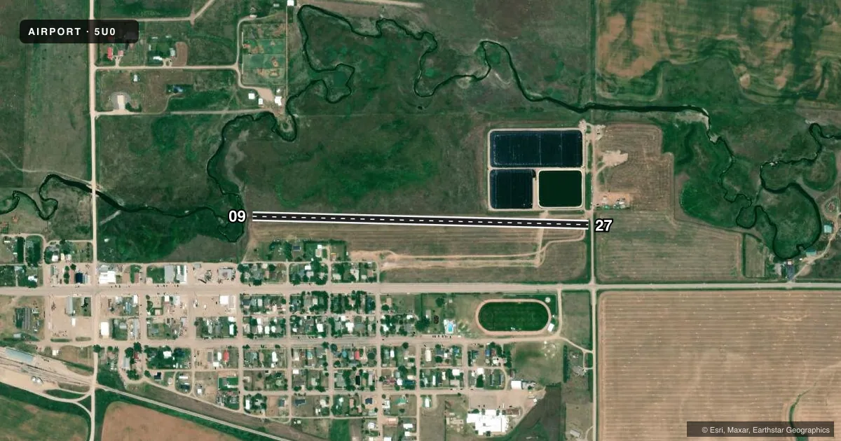
- WATERFOWL AND MIGRATORY BIRD FLOCKS COMMON AROUND SEWAGE LAGOONS LOCATED IMMEDIATELY NORTH OF RY 27 THLD.
- FOR CD CTC SALT LAKE ARTCC AT 801-320-2568.
VFR map & nearby airports
VFR sectional. Tap any ICAO chip to open that airport.
Key facts · 5U0
Answer card- ICAO
- 5U0
- Name
- DENTON
- Location
- DENTON, MONTANA
- Elevation
- 3,594 ft MSL
- Traffic pattern altitude
- 4,594 ft MSL (1,000 AGL)
- Control tower
- Non-towered (use CTAF)
- Total runways
- 1
- Longest runway
- 09/27 · 2,550 ft
- Published ILS approaches
- 0
- Published frequencies
- 1
- Magnetic variation
- 16°
- Current flight rules
- VFR
- Current wind
- 270° at 10 kt
- Favored runway now
- RWY 27
Denton Airport (5U0) sits in Denton, Montana. The field elevation is 3,594 ft MSL. It has one runway. Runway 09/27 is 2,550 ft of turf. The runway headings are 91° and 271° magnetic. There is no control tower. CTAF is 122.9.
No ILS approaches are published here. The pattern altitude is not published, so use the standard 1,000 ft AGL pattern unless the current Chart Supplement says otherwise. That puts the light-piston pattern at about 4,594 ft MSL based on the field elevation. Check the current Chart Supplement before you go.
There are no on-field FBOs listed. Contact the airport operator directly before arrival, or call the field on CTAF for current fuel and service availability. Published remarks note waterfowl and migratory birds near the sewage lagoons just north of the runway 27 threshold. That is worth keeping in mind on departure and on the approach to 27. For clearance delivery, contact Salt Lake ARTCC at 801-320-2568. At this elevation, expect a higher true airspeed for a given indicated speed. Turf also means surface condition matters. Check the runway condition before you commit.