METAR & TAF 9S7
9S7 does not publish a METAR.
Showing the nearest reporting station: KLWT (LEWISTOWN MUNI) · 30.6 NM away. Conditions at 9S7 may differ.
METAR · KLWT
Observed 16:54Z
KLWT 241654Z AUTO 27010KT 10SM CLR 30/11 A3000 RMK AO2 SLP113 T03000111
- Wind
- 270° @ 10 kt
- Visibility
- 10 SM
- Temp / Dew
- 30°C / 11°C
- Altimeter
- 30.00 inHg
- Clouds
- CLR
- Density alt
- 5,860 ft
- Ceiling
- Unlimited
- Rules
- VFR
Airport info & contacts
Manager on record, flight service, ARTCC, attendance schedule and pattern altitude — published by the FAA and refreshed every 28 days.
Location
- From city
- 1 NM S
- VFR sectional
- GREAT FALLS
- ARTCC
- ZLC · SALT LAKE CITY
- NOTAM facility
- GTF (NOTAM-D)
Airport manager
- Name
- RALPH ROGERS
- Phone
- 406-462-5487
- Address
- BOX 63, WINIFRED MT 59489
Flight service · Hours
- FSS GTF
- GREAT FALLS1-800-WX-BRIEF
- Attendance
- Unattended
Frequencies
Tap any row to copy the frequency to your clipboard.
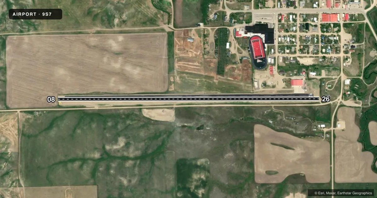
Runways & pattern
Full pagePattern entry · RWY 26
LEFT TRAFFICAirport sketch
Runways drawn to scale from FAA survey coordinates, rendered over satellite imagery. Not for navigation.
Approaches & charts
Services on the field
Fuel grades, oxygen, maintenance, ramp storage and lighting — as declared to the FAA by the airport operator.
Fuel & services
- Fuel
- 100LL
- Oxygen (bottled)
- Not available
- Oxygen (bulk)
- Not available
- Airframe repair
- Not available
- Power plant repair
- Not available
- Other services
- AGRI
Ramp & ground
- Transient storage
- Tie-down
- Hangar
- Landing fee
- No fee published
- Customs
- Not available
- Wind indicator
- Yes
- Segmented circle
- No
Fuel & FBOs
Cheapest 100LL and Jet A on the field and nearby. Always confirm with the FBO before taxi.
Airport notes
Surface conditions, obstructions, local procedures, lighting outages and other notes published with each FAA cycle.
General notes
- MAY BE UNMOWED/UNPLOWED. EMERG CTC 406-462-5487.
- RY SFC SLOPE VARIES FROM NEARLY FLAT ON BOTH ENDS TO 3 PERCENT NEAR THE MIDDLE.
- FOR CD CTC SALT LAKE ARTCC AT 801-320-2568.
- UNLGTD TWR 0.6 NM NE OF ARPT 143 FT AGL.
Fuel notes
- 100LLAVBL 24 HRS BY CREDIT CARD.
Runway surface & condition
- 08/26PWR LINE PARLS RWY FULL LEN 261 FT S OF CNTRLN.
Approach & departure obstructions
- 08RWY 08/26 MKD FULL LENGTH WITH WHITE CONES.
- 08RWY 26 SLPS UPHILL AT 50:1 FOR 777 FT
Other notes
- ESTABLISHED PRIOR TO 1959.
VFR map & nearby airports
VFR sectional. Tap any ICAO chip to open that airport.
Key facts · 9S7
Answer card- ICAO
- 9S7
- Name
- WINIFRED
- Location
- WINIFRED, MONTANA
- Elevation
- 3,354 ft MSL
- Traffic pattern altitude
- 4,354 ft MSL (1,000 AGL)
- Control tower
- Non-towered (use CTAF)
- Total runways
- 1
- Longest runway
- 08/26 · 4,400 ft
- Published ILS approaches
- 0
- Published frequencies
- 1
- Magnetic variation
- 16°
- Current flight rules
- VFR
- Current wind
- 270° at 10 kt
- Favored runway now
- RWY 26
WINIFRED (9S7) sits in Winifred, Montana. The field elevation is 3,354 ft MSL. It has one runway. Runway 08/26 is 4,400 ft of turf, which is the longest runway on the field. There is no control tower. CTAF is 122.9. No ILS approaches are published here.
Pattern altitude is not published in the facts. Use the standard 1,000 ft AGL pattern unless the current Chart Supplement says otherwise. At this elevation, performance planning matters. The airport may also be unmowed or unplowed, so check field condition before you go.
Published remarks matter here. A power line runs parallel to the runway full length, 261 ft south of the centerline. An unlighted tower sits 0.6 NM northeast of the airport. Runway 08/26 is marked full length with white cones. Runway 26 also slopes uphill for the first 777 ft. 100LL is available 24 hours by credit card. No on-field FBOs are listed, so verify services with the airport operator or the FBO directly by phone before arrival. For clearance delivery, contact Salt Lake ARTCC at 801-320-2568.