METAR & TAF 7S6
7S6 does not publish a METAR.
Showing the nearest reporting station: KBZN (BOZEMAN YELLOWSTONE INTL) · 44.3 NM away. Conditions at 7S6 may differ.
METAR · KBZN
Observed 12:56Z
KBZN 271256Z 15005KT 10SM CLR 15/12 A3011 RMK AO2 SLP152 T01500122
- Wind
- 150° @ 5 kt
- Visibility
- 10 SM
- Temp / Dew
- 15°C / 12°C
- Altimeter
- 30.11 inHg
- Clouds
- CLR
- Density alt
- 6,045 ft
- Ceiling
- Unlimited
- Rules
- VFR
Airport info & contacts
Manager on record, flight service, ARTCC, attendance schedule and pattern altitude — published by the FAA and refreshed every 28 days.
Location
- From city
- 3 NM S
- VFR sectional
- GREAT FALLS
- ARTCC
- ZLC · SALT LAKE CITY
- NOTAM facility
- GTF (NOTAM-D)
Airport manager
- Name
- KURT BURNS
- Phone
- 406-261-4556
- Address
- PO BOX 248, CLYDE PARK MT 59018
Flight service · Hours
- FSS GTF
- GREAT FALLS1-800-WX-BRIEF
- Attendance
- Unattended
Frequencies
Tap any row to copy the frequency to your clipboard.
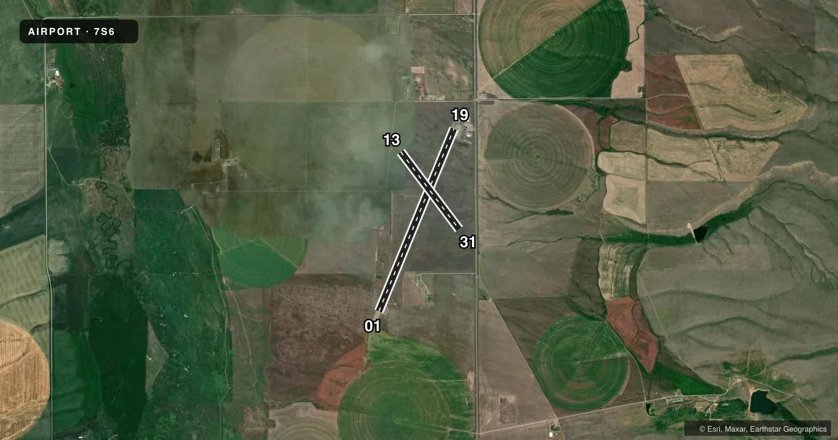
Runways & pattern
Full pagePattern entry · RWY 13
LEFT TRAFFIC| Runway | Heading (°M) | Length | Surface | Traffic |
|---|---|---|---|---|
| 01/19 | 11° / 191° | 6,100 ft | ASPH | Standard L |
| 13/31Favored | 132° / 312° | 2,999 ft | TURF | Standard L |
Runway end performance
| End | TORA | TODA | ASDA | LDA | VGSI | Approach lights | Obstruction |
|---|---|---|---|---|---|---|---|
| 01 | — | — | — | — | PAPI 2-box left(3°) | — | — |
| 19 | — | — | — | — | PAPI 2-box left(3°) | — | — |
Declared distances in feet. TORA = takeoff run available, TODA = takeoff distance, ASDA = accelerate-stop, LDA = landing distance.
Airport sketch
Runways drawn to scale from FAA survey coordinates, rendered over satellite imagery. Not for navigation.
Approaches & charts
Services on the field
Fuel grades, oxygen, maintenance, ramp storage and lighting — as declared to the FAA by the airport operator.
Fuel & services
- Fuel
- 100LL
- Oxygen (bottled)
- Not available
- Oxygen (bulk)
- Not available
Ramp & ground
- Transient storage
- Tie-down
- Landing fee
- No fee published
- Customs
- Not available
- Lighting schedule
- SEE RMK
- Beacon schedule
- SS-SR
- Beacon
- White / Green (civil land)(WG)
- Wind indicator
- Lighted
- Segmented circle
- Yes
Fuel & FBOs
Cheapest 100LL and Jet A on the field and nearby. Always confirm with the FBO before taxi.
Airport notes
Surface conditions, obstructions, local procedures, lighting outages and other notes published with each FAA cycle.
General notes
- PHONE LOCATED IN PILOTS LOUNGE.
- ANTELOPE & BIRDS FREQUENTLY ON & INVOF ARPT.
- IRRIGATION TWRS AER 13.
- ARPT CLOSED TO HEL OPS OVER 5000 LBS EXC IN DESIGNATED FIRE FIGHTING PARKING AREA.
- FOR CD CTC SALT LAKE ARTCC AT 801-320-2568.
- RWY 13/31 NO CONES MARKING RWY EDGE, ONLY CONES ON RWY ENDS.
- SEE HTTPS://WEATHERCAMS.FAA.GOV FOR CURRENT RWY CONDS.
Lighting notes
- ACTVT MIRL RY 01/19 & PAPI RYS 01 & 19 - CTAF.
Runway surface & condition
- 01/19PCR VALUE: 130/F/D/X/T
Other notes
- EXISTED PRIOR TO 1959.
VFR map & nearby airports
VFR sectional. Tap any ICAO chip to open that airport.
Key facts · 7S6
Answer card- ICAO
- 7S6
- Name
- WHITE SULPHUR SPRINGS
- Location
- WHITE SULPHUR SPRINGS, MONTANA
- Elevation
- 5,065.4 ft MSL
- Traffic pattern altitude
- 6,065.4 ft MSL (1,000 AGL)
- Control tower
- Non-towered (use CTAF)
- Total runways
- 2
- Longest runway
- 01/19 · 6,100 ft
- Published ILS approaches
- 0
- Published frequencies
- 1
- Magnetic variation
- 11°
- Current flight rules
- VFR
- Current wind
- 150° at 5 kt
- Favored runway now
- RWY 13
White Sulphur Springs Airport sits in White Sulphur Springs, Montana. Field elevation is 5,065.4 ft MSL. The airport has two runways. The longest is runway 01/19 at 6,100 ft. Runway 13/31 is turf and measures 2,999 ft. This is an uncontrolled field with CTAF 122.9. No ILS approaches are published.
Pattern altitude is not published. Use the standard 1,000 ft AGL for light piston traffic unless the current Chart Supplement says otherwise. White Sulphur Springs Airport carries AVGAS 100LL through the on-field FBO, White Sulphur Springs Airport. Call (406) 261-4556 for current service details. The phone is located in the pilots lounge.
This is a high-elevation airport, so aircraft performance will be different from a low field. Expect to plan for density altitude. The published remarks also flag wildlife near the airport. Antelope and birds are frequently on or near the field. Runway 13/31 has no cones marking the runway edge. Only the runway ends are coned. Medium intensity runway lights are on runway 01/19. PAPI is activated on runways 01 and 19 by CTAF. For clearance delivery, contact Salt Lake ARTCC at 801-320-2568. Check current runway conditions before departure.