METAR & TAF 9U1
9U1 does not publish a METAR.
Showing the nearest reporting station: KLVM (MISSION FLD) · 23.2 NM away. Conditions at 9U1 may differ.
METAR · KLVM
Observed 05:53Z
KLVM 270553Z AUTO 00000KT -RA FEW036 BKN110 19/14 A3003 RMK AO2 RAE00B20 TSE0458B20E42 SLP120 P0002 60005 T01890139 10311 20183 54000 $
- Wind
- 000° @ 0 kt
- Visibility
- —
- Temp / Dew
- 19°C / 14°C
- Altimeter
- 30.03 inHg
- Clouds
- BKN
- Density alt
- 6,717 ft
- Ceiling
- 11,000 ft AGL
- Rules
- VFR
Airport info & contacts
Manager on record, flight service, ARTCC, attendance schedule and pattern altitude — published by the FAA and refreshed every 28 days.
Location
- From city
- 4 NM NW
- VFR sectional
- GREAT FALLS
- ARTCC
- ZLC · SALT LAKE CITY
- NOTAM facility
- GTF (NOTAM-D)
Airport manager
- Name
- PAUL LYMAN
- Phone
- 406-451-1944
- Address
- COUNTY BLDG, 414 E CALLENDER, LIVINGSTON MT 59047
Flight service · Hours
- FSS GTF
- GREAT FALLS1-800-WX-BRIEF
- Attendance
- Unattended
Frequencies
Tap any row to copy the frequency to your clipboard.
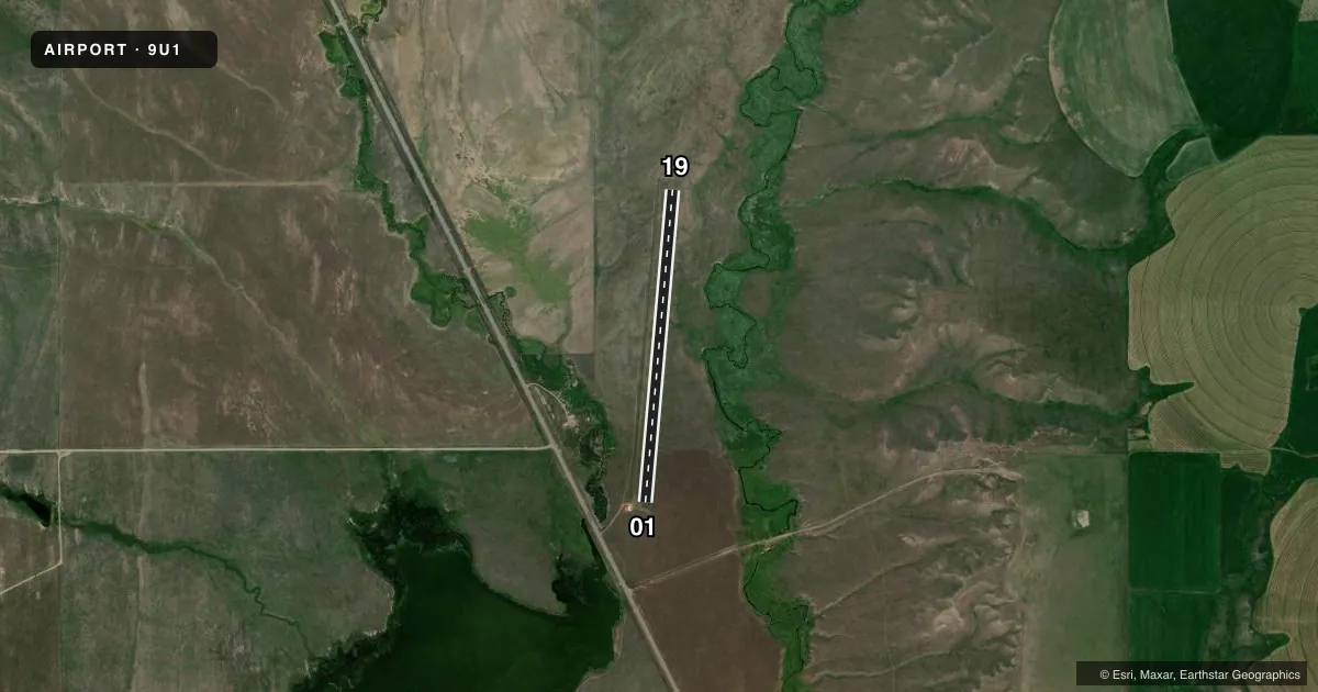
Runways & pattern
Full pagePattern entry · RWY 01
LEFT TRAFFICAirport sketch
Runways drawn to scale from FAA survey coordinates, rendered over satellite imagery. Not for navigation.
Approaches & charts
Services on the field
Fuel grades, oxygen, maintenance, ramp storage and lighting — as declared to the FAA by the airport operator.
Fuel & services
- Fuel
- Not available
- Oxygen (bottled)
- Not available
- Oxygen (bulk)
- Not available
- Airframe repair
- Not available
- Power plant repair
- Not available
Ramp & ground
- Transient storage
- Not published
- Landing fee
- No fee published
- Customs
- Not available
- Wind indicator
- Yes
- Segmented circle
- No
Fuel & FBOs
Cheapest 100LL and Jet A on the field and nearby. Always confirm with the FBO before taxi.
Airport notes
Surface conditions, obstructions, local procedures, lighting outages and other notes published with each FAA cycle.
General notes
- FENCE PARALLEL TO RY BOTH SIDES 100 FT E & 105 FT W.
- WILDLIFE ON & INVOF ARPT.
- FOR CD CTC BIG SKY APCH AT 208-364-5860/5861, IF UNABLE CTC SALT LAKE ARTCC AT 801-320-2568.
Approach & departure obstructions
- 0101/19 RWY AND THR MKD WITH W CONES FULL LEN.
Other notes
- 01/19GOPHER & BADGER HOLES PRESENT FULL LENGTH.
- 01/19SOFT WHEN WET; GOPHER HOLES ON RWY; NO SNOW REMOVAL
VFR map & nearby airports
VFR sectional. Tap any ICAO chip to open that airport.
Key facts · 9U1
Answer card- ICAO
- 9U1
- Name
- WILSALL
- Location
- WILSALL, MONTANA
- Elevation
- 5,140 ft MSL
- Traffic pattern altitude
- 6,140 ft MSL (1,000 AGL)
- Control tower
- Non-towered (use CTAF)
- Total runways
- 1
- Longest runway
- 01/19 · 3,100 ft
- Published ILS approaches
- 0
- Published frequencies
- 1
- Magnetic variation
- 16°
- Current flight rules
- VFR
- Current wind
- 000° at 0 kt
- Favored runway now
- –
Wilsall Airport (9U1) sits in Wilsall, Montana. The field elevation is 5,140 ft MSL. It has one runway. Runway 01/19 is a 3,100 ft turf strip with magnetic headings of 5° and 185°. No tower is published here. CTAF is 122.9.
No ILS approaches are published. Pattern altitude is not published, so use the standard 1,000 ft AGL for light piston traffic unless the current Chart Supplement says otherwise. This is a high-elevation turf field, so expect performance to matter. The published remarks also call out soft conditions when wet, no snow removal, wildlife in the area. They also note gopher or badger holes along the runway. White cones mark the runway and threshold along the full length.
There are no on-field FBOs listed. For clearance delivery, contact Big Sky Approach at 208-364-5860 or 208-364-5861. If that is not available, contact Salt Lake ARTCC at 801-320-2568. The runway has fences parallel to both sides, close in on the field. Plan a careful inspection and a conservative go-around decision if the surface looks rough or wet.