METAR & TAF KLVM
Current METAR
Observed 09:53Z
KLVM 270953Z AUTO 28003KT CLR 15/13 A3005 RMK AO2 SLP123 T01500128 $
- Wind
- 280° @ 3 kt
- Visibility
- —
- Temp / Dew
- 15°C / 13°C
- Altimeter
- 30.05 inHg
- Clouds
- CLR
- Density alt
- 5,616 ft
- Ceiling
- Unlimited
- Rules
- VFR
Airport info & contacts
Manager on record, flight service, ARTCC, attendance schedule and pattern altitude — published by the FAA and refreshed every 28 days.
Location
- From city
- 5 NM E
- VFR sectional
- GREAT FALLS
- ARTCC
- ZLC · SALT LAKE CITY
- NOTAM facility
- LVM (NOTAM-D)
Airport manager
- Name
- KELLY HANCOCK
- Phone
- 406-223-2391
- Address
- COUNTY BLDG, 414 E CALLENDER, LIVINGSTON MT 59047
Flight service · Hours
- FSS GTF
- GREAT FALLS1-800-WX-BRIEF
- Attendance
- 0800-1700
Frequencies
Tap any row to copy the frequency to your clipboard.
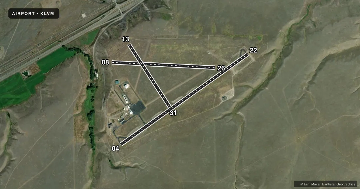
Runways & pattern
Full pagePattern entry · RWY 26
LEFT TRAFFIC| Runway | Heading (°M) | Length | Surface | Traffic |
|---|---|---|---|---|
| 04/22 | 39° / 219° | 5,701 ft | ASPH | Standard L |
| 08/26Favored | 78° / 258° | 3,762 ft | TURF | Standard L |
| 13/31 | 132° / 312° | 2,724 ft | TURF | Standard L |
Runway end performance
| End | TORA | TODA | ASDA | LDA | VGSI | Approach lights | Obstruction |
|---|---|---|---|---|---|---|---|
| 22 | — | — | — | — | PAPI 4-box left(3°) | — | — |
Declared distances in feet. TORA = takeoff run available, TODA = takeoff distance, ASDA = accelerate-stop, LDA = landing distance.
Airport sketch
Runways drawn to scale from FAA survey coordinates, rendered over satellite imagery. Not for navigation.
Approaches & charts
Services on the field
Fuel grades, oxygen, maintenance, ramp storage and lighting — as declared to the FAA by the airport operator.
Fuel & services
- Fuel
- 100LLA
- Oxygen (bottled)
- Not available
- Oxygen (bulk)
- Not available
- Airframe repair
- Not available
- Power plant repair
- Not available
- Other services
- AGRI,AMB
Ramp & ground
- Transient storage
- Tie-down
- Hangar
- Landing fee
- Yes
- Customs
- Not available
- Lighting schedule
- SEE RMK
- Beacon schedule
- SS-SR
- Beacon
- White / Green (civil land)(WG)
- Wind indicator
- Lighted
- Segmented circle
- No
Fuel & FBOs
Cheapest 100LL and Jet A on the field and nearby. Always confirm with the FBO before taxi.
Airport notes
Surface conditions, obstructions, local procedures, lighting outages and other notes published with each FAA cycle.
General notes
- RWY 31 MTN 1 MILE AT 23:1 RATIO.
- WILDLIFE ON & INVOF ARPT.
- AG OPS APR THROUGH SEP.
- FOR CD IF UNA TO CTC ON FSS FREQ, CTC SALT LAKE ARTCC AT 801-320-2568.
- COLD TEMPERATURE AIRPORT. ALTITUDE CORRECTION REQUIRED AT OR BELOW -28C.
- PAPI RWY 22 OPR CONSLY.
- AIRFIELD SFC COND UNMONITORED 1700-0800.
Lighting notes
- ACTIVATE MIRL RWY 04/22 - 123.0.
Fuel notes
- AWKENDS AND AFT HRS CALL 406-222-6504.
Approach & departure obstructions
- 08RWYS 08 & 26 THLDS & FIRST 200 FT MKD WITH W CONES.
- 13RWYS 13 & 31 THLDS & FIRST 200 FT MKD WITH W CONES.
- 22PAPI UNUSBL BYD 5 DEGS RIGHT OF CNTRLN.
Other notes
- LDG FEE FOR ACFT OVR 12500 LBS.
- 08/26MOWING IREG.
- 13/31MOWING IREG.
VFR map & nearby airports
VFR sectional. Tap any ICAO chip to open that airport.
Key facts · KLVM
Answer card- ICAO
- KLVM
- Name
- MISSION FLD
- Location
- LIVINGSTON, MONTANA
- Elevation
- 4,659.4 ft MSL
- Traffic pattern altitude
- 5,659.4 ft MSL (1,000 AGL)
- Control tower
- Non-towered (use CTAF)
- Total runways
- 3
- Longest runway
- 04/22 · 5,701 ft
- Published ILS approaches
- 0
- Published frequencies
- 4
- Magnetic variation
- 15°
- Current flight rules
- VFR
- Current wind
- 280° at 3 kt
- Favored runway now
- RWY 26
Mission Field sits in Livingston, Montana. The field elevation is 4,659.4 ft MSL. It has three runways. The longest is runway 04/22 at 5,701 ft asphalt. Runways 08/26 and 13/31 are turf. There is no control tower. Big Sky provides approach and departure service on 119.55 and 235.775. No ILS approaches are published here. Pattern altitude is not published. Use 5,659.4 ft MSL for a standard 1,000 ft AGL light piston pattern unless the current Chart Supplement says otherwise.
Yellowstone Air Service is on the field. It carries 100LL, Jet A and Jet A Prist. Call (406) 222-6504 for current service details before arrival. Runway 04/22 lighting is activated by radio on 123.0. The PAPI on runway 22 runs continuously. Runway 22’s PAPI is unusable more than 5 degrees right of centerline. Runway 08 and 26 thresholds plus the first 200 ft are marked with white cones. Runway 13 and 31 thresholds plus the first 200 ft are also marked with white cones.
This is a high-elevation field. Expect density altitude to matter. Wildlife is present on and near the airport. Agricultural work happens from April through September. Runway 31 has a mountain about 1 mile away at a 23 to 1 ratio. Check the current Chart Supplement for any operational notes before you go. Surface condition is not monitored from 1700 to 0800.