METAR & TAF 9S5
9S5 does not publish a METAR.
Showing the nearest reporting station: KBZN (BOZEMAN YELLOWSTONE INTL) · 18.6 NM away. Conditions at 9S5 may differ.
METAR · KBZN
Observed 12:56Z
KBZN 271256Z 15005KT 10SM CLR 15/12 A3011 RMK AO2 SLP152 T01500122
- Wind
- 150° @ 5 kt
- Visibility
- 10 SM
- Temp / Dew
- 15°C / 12°C
- Altimeter
- 30.11 inHg
- Clouds
- CLR
- Density alt
- 4,835 ft
- Ceiling
- Unlimited
- Rules
- VFR
Airport info & contacts
Manager on record, flight service, ARTCC, attendance schedule and pattern altitude — published by the FAA and refreshed every 28 days.
Location
- From city
- 1 NM SE
- VFR sectional
- GREAT FALLS
- ARTCC
- ZLC · SALT LAKE CITY
- NOTAM facility
- GTF (NOTAM-D)
Airport manager
- Name
- NICK BILTON
- Phone
- 406-570-0803
- Address
- P.O. BOX 978, THREE FORKS MT 59752
Flight service · Hours
- FSS GTF
- GREAT FALLS1-800-WX-BRIEF
- Attendance
- ALL
Frequencies
Tap any row to copy the frequency to your clipboard.
Runways & pattern
Full pagePattern entry · RWY 21
LEFT TRAFFICRunway end performance
| End | TORA | TODA | ASDA | LDA | VGSI | Approach lights | Obstruction |
|---|---|---|---|---|---|---|---|
| 03 | — | — | — | — | PAPI 2-box left(3°) | — | — |
| 21 | — | — | — | — | PAPI 2-box left(3.25°) | — | — |
Declared distances in feet. TORA = takeoff run available, TODA = takeoff distance, ASDA = accelerate-stop, LDA = landing distance.
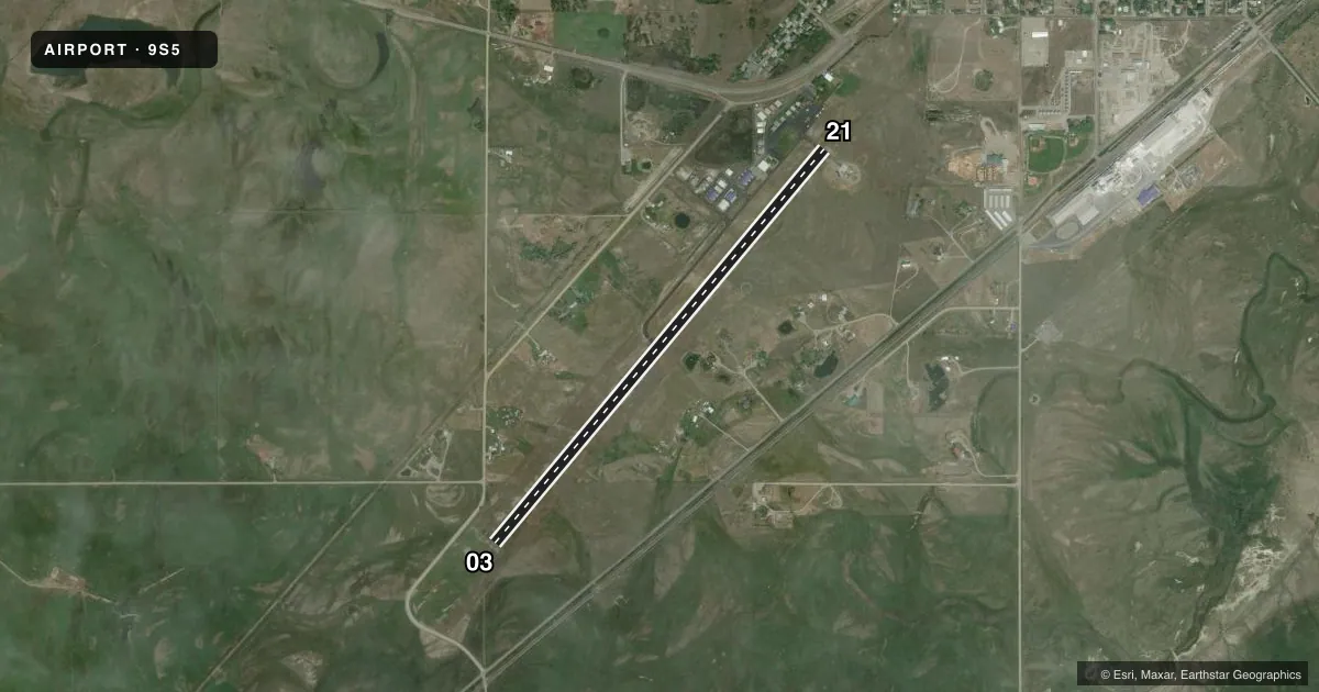
Airport sketch
Runways drawn to scale from FAA survey coordinates, rendered over satellite imagery. Not for navigation.
Approaches & charts
Services on the field
Fuel grades, oxygen, maintenance, ramp storage and lighting — as declared to the FAA by the airport operator.
Fuel & services
- Fuel
- 100LL
- Oxygen (bottled)
- Not available
- Oxygen (bulk)
- Not available
- Airframe repair
- Major
- Power plant repair
- Major
- Other services
- AGRI,INSTR,PAJA
Ramp & ground
- Transient storage
- Tie-down
- Hangar
- Landing fee
- No fee published
- Customs
- Not available
- Lighting schedule
- SEE RMK
- Beacon schedule
- SS-SR
- Beacon
- White / Green (civil land)(WG)
- Wind indicator
- Lighted
- Segmented circle
- Yes
Fuel & FBOs
Cheapest 100LL and Jet A on the field and nearby. Always confirm with the FBO before taxi.
Airport notes
Surface conditions, obstructions, local procedures, lighting outages and other notes published with each FAA cycle.
General notes
- OCCASIONAL AEROBATIC MANEUVERS INVOF ARPT.
- UPON DEPARTURE, ALL ACFT MUST REACH 500 FT ALTITUDE PRIOR TO MAKING ANY TURNS.
- FOR CD CTC BIG SKY APCH AT 208-364-5860/5861, IF UNABLE CTC SALT LAKE ARTCC AT 801-320-2568.
Lighting notes
- ACTVT REILS RWY 03 & 21; PAPI RWY 03 & 21; MIRL RWY 03/21 - CTAF
- ULTRALIGHT ACTIVITY ON & INVOF ARPT.
Fuel notes
- 100LLFUEL 24 HR CREDIT CARD SVC AVBL.
Other notes
- ARPT ESTAB PRIOR TO 1959.
- AUTOMATED UNICOM.
VFR map & nearby airports
VFR sectional. Tap any ICAO chip to open that airport.
Key facts · 9S5
Answer card- ICAO
- 9S5
- Name
- THREE FORKS
- Location
- THREE FORKS, MONTANA
- Elevation
- 4,089.4 ft MSL
- Traffic pattern altitude
- 5,089.4 ft MSL (1,000 AGL)
- Control tower
- Non-towered (use CTAF)
- Total runways
- 1
- Longest runway
- 03/21 · 5,099 ft
- Published ILS approaches
- 0
- Published frequencies
- 2
- Magnetic variation
- 16°
- Current flight rules
- VFR
- Current wind
- 150° at 5 kt
- Favored runway now
- RWY 21
Three Forks Airport is in Three Forks, Montana. The field elevation is 4,089.4 ft MSL. It has one runway. Runway 03/21 is 5,099 ft long and asphalt. There are no published ILS approaches here. The airport is not towered. CTAF and UNICOM are both 122.8.
The pattern altitude is not published. Use the standard 1,000 ft AGL for light piston traffic unless the current FAA Chart Supplement says otherwise. The airport has runway end identifier lights, precision approach path indicators and medium intensity runway lights on 03/21. Fuel is available from Headwaters Flying Service. It carries 100LL. The remarks also note 24-hour credit card fuel service. For clearance delivery, pilots are told to contact Big Sky Approach, or Salt Lake ARTCC if needed.
First-time visitors should pay attention to the elevation. Density altitude can be a factor, especially on warm days. The remarks also call out occasional aerobatic activity near the airport and ultralight activity on and near the field. After departure, aircraft must reach 500 ft before making any turns. Check the current FAA Chart Supplement for any other local procedures before you go.