METAR & TAF 3U9
3U9 does not publish a METAR.
Showing the nearest reporting station: KBTM (BERT MOONEY) · 22.4 NM away. Conditions at 3U9 may differ.
METAR · KBTM
Observed 12:53Z
KBTM 271253Z AUTO 13005KT 5SM HZ CLR 10/06 A3021 RMK AO2 SLP172 T01000061
- Wind
- 130° @ 5 kt
- Visibility
- 5 SM
- Temp / Dew
- 10°C / 6°C
- Altimeter
- 30.21 inHg
- Clouds
- CLR
- Density alt
- 5,201 ft
- Ceiling
- Unlimited
- Rules
- MVFR
Airport info & contacts
Manager on record, flight service, ARTCC, attendance schedule and pattern altitude — published by the FAA and refreshed every 28 days.
Location
- From city
- 2 NM S
- VFR sectional
- GREAT FALLS
- ARTCC
- ZLC · SALT LAKE CITY
- NOTAM facility
- GTF (NOTAM-D)
Airport manager
- Name
- AL MARTINI
- Phone
- (406) 431-7519
- Address
- PO BOX 2, BOULDER MT 59632
Flight service · Hours
- FSS GTF
- GREAT FALLS1-800-WX-BRIEF
- Attendance
- Unattended
Frequencies
Tap any row to copy the frequency to your clipboard.
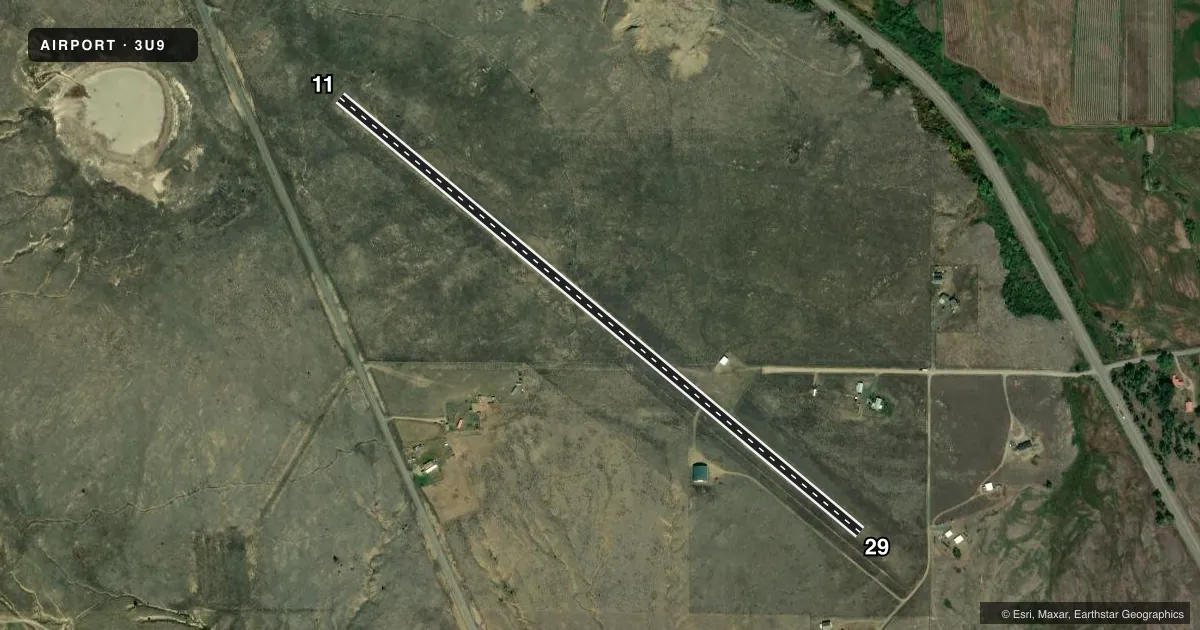
Runways & pattern
Full pagePattern entry · RWY 11
LEFT TRAFFICAirport sketch
Runways drawn to scale from FAA survey coordinates, rendered over satellite imagery. Not for navigation.
Approaches & charts
Services on the field
Fuel grades, oxygen, maintenance, ramp storage and lighting — as declared to the FAA by the airport operator.
Fuel & services
- Fuel
- Not available
- Oxygen (bottled)
- Not available
- Oxygen (bulk)
- Not available
- Airframe repair
- Not available
- Power plant repair
- Not available
Ramp & ground
- Transient storage
- Tie-down
- Landing fee
- No fee published
- Customs
- Not available
- Wind indicator
- Yes
- Segmented circle
- Yes
Fuel & FBOs
Cheapest 100LL and Jet A on the field and nearby. Always confirm with the FBO before taxi.
Airport notes
Surface conditions, obstructions, local procedures, lighting outages and other notes published with each FAA cycle.
General notes
- NO SNOW REMOVAL
- NO PHONE ON AIRPORT.
- -2 FT DRAINAGE DITCH +1 FT BERM WEST SIDE OF RY FULL LENGTH; 43 FT FM RY 11/29 CNTRLN.
- FOR CD CTC HELENA APCH AT 406-449-5756/5761, WHEN APCH CLSD CTC SALT LAKE ARTCC AT 801-320-2568.
Approach & departure obstructions
- 11RY 11/29 THLDS & EDGES MARKED WITH WHITE CONES
Other notes
- 11/29HAS 1% TO 3% UPHILL GRADIENT FROM RY 29 END TO RY 11 END.
VFR map & nearby airports
VFR sectional. Tap any ICAO chip to open that airport.
Key facts · 3U9
Answer card- ICAO
- 3U9
- Name
- BOULDER
- Location
- BOULDER, MONTANA
- Elevation
- 4,968 ft MSL
- Traffic pattern altitude
- 5,968 ft MSL (1,000 AGL)
- Control tower
- Non-towered (use CTAF)
- Total runways
- 1
- Longest runway
- 11/29 · 3,675 ft
- Published ILS approaches
- 0
- Published frequencies
- 1
- Magnetic variation
- 17°
- Current flight rules
- MVFR
- Current wind
- 130° at 5 kt
- Favored runway now
- RWY 11
Boulder Airport (3U9) sits in Boulder, Montana. Field elevation is 4,968 ft MSL. The airport has one runway. Runway 11/29 is 3,675 ft of turf, which is the longest runway on the field. It is a non-towered airport, so use CTAF 122.9 for local traffic calls.
No ILS approaches are published here. Pattern altitude is not published in the facts, so use standard 1,000 ft AGL for light piston operations unless the current Chart Supplement says otherwise. The runway markings use white cones for the thresholds and edges. The runway has a 1 percent to 3 percent uphill gradient from the 29 end toward the 11 end. There is also a 2-foot drainage ditch and a 1-foot berm on the west side of the runway for the full length. They sit about 43 feet from the centerline.
There are no on-field FBOs listed. There is no snow removal. For clearance delivery, contact Helena Approach at 406-449-5756 or 406-449-5761. When approach is closed, contact Salt Lake ARTCC at 801-320-2568. There is no phone on the airport, so plan your calls before you roll. This is a high-elevation turf strip with no tower and no published instrument approach support, so a first-time pilot should plan for density altitude, runway condition and the surrounding terrain before arrival.