METAR & TAF 38S
38S does not publish a METAR.
Showing the nearest reporting station: KBTM (BERT MOONEY) · 28.3 NM away. Conditions at 38S may differ.
METAR · KBTM
Observed 12:53Z
KBTM 271253Z AUTO 13005KT 5SM HZ CLR 10/06 A3021 RMK AO2 SLP172 T01000061
- Wind
- 130° @ 5 kt
- Visibility
- 5 SM
- Temp / Dew
- 10°C / 6°C
- Altimeter
- 30.21 inHg
- Clouds
- CLR
- Density alt
- 4,859 ft
- Ceiling
- Unlimited
- Rules
- MVFR
Airport info & contacts
Manager on record, flight service, ARTCC, attendance schedule and pattern altitude — published by the FAA and refreshed every 28 days.
Location
- From city
- 2 NM W
- VFR sectional
- GREAT FALLS
- ARTCC
- ZLC · SALT LAKE CITY
- NOTAM facility
- GTF (NOTAM-D)
Airport manager
- Name
- TONY PFAFF
- Phone
- 406-490-3071
- Address
- 2944 GREENHOUSE ROAD, DEER LODGE MT 59722
Flight service · Hours
- FSS GTF
- GREAT FALLS1-800-WX-BRIEF
- Attendance
- Unattended
Frequencies
Tap any row to copy the frequency to your clipboard.
Runways & pattern
Full pagePattern entry · RWY 13
LEFT TRAFFICRunway end performance
| End | TORA | TODA | ASDA | LDA | VGSI | Approach lights | Obstruction |
|---|---|---|---|---|---|---|---|
| 13 | — | — | — | — | PAPI 2-box left(3.22°) | — | — |
| 31 | — | — | — | — | PAPI 2-box left(2.72°) | — | — |
Declared distances in feet. TORA = takeoff run available, TODA = takeoff distance, ASDA = accelerate-stop, LDA = landing distance.
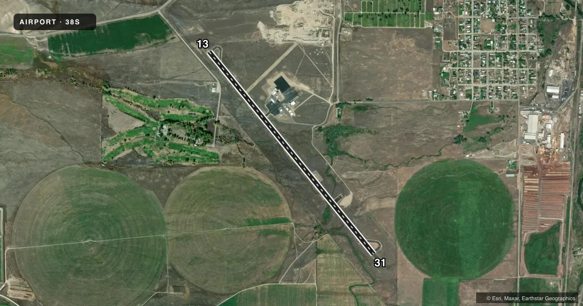
Airport sketch
Runways drawn to scale from FAA survey coordinates, rendered over satellite imagery. Not for navigation.
Approaches & charts
Services on the field
Fuel grades, oxygen, maintenance, ramp storage and lighting — as declared to the FAA by the airport operator.
Fuel & services
- Fuel
- 100LLA
- Oxygen (bottled)
- Not available
- Oxygen (bulk)
- Not available
- Airframe repair
- Not available
- Power plant repair
- Not available
- Other services
- AGRI
Ramp & ground
- Transient storage
- Tie-down
- Landing fee
- No fee published
- Customs
- Not available
- Lighting schedule
- SEE RMK
- Beacon schedule
- SS-SR
- Beacon
- White / Green (civil land)(WG)
- Wind indicator
- Lighted
- Segmented circle
- Yes
Fuel & FBOs
Cheapest 100LL and Jet A on the field and nearby. Always confirm with the FBO before taxi.
Airport notes
Surface conditions, obstructions, local procedures, lighting outages and other notes published with each FAA cycle.
General notes
- SINGLE WHEEL APRON WEIGHT BEARING CAPACITY 30,000 LBS FOR SW APRON, 50,000 LBS FOR NE APRON, TWY TO NE APRON 50,000 LBS.
- FOR CD CTC SALT LAKE ARTCC AT 801-320-2568.
- COLD TEMPERATURE AIRPORT. ALTITUDE CORRECTION REQUIRED AT OR BELOW -22C.
Lighting notes
- ACTVT MIRL RY 13/31 & PAPI RYS 13 & 31 - CTAF.
Runway surface & condition
- 13/31RY 13/31 EXTDD SE END.
Approach & departure obstructions
- 31+28' TREES 250' LEFT OF RWY CNTRLN EXTENDED.
Other notes
- MANAGERALSO 406-846-3825. OR 406-490-0297 OR 406-490-3071
VFR map & nearby airports
VFR sectional. Tap any ICAO chip to open that airport.
Key facts · 38S
Answer card- ICAO
- 38S
- Name
- DEER LODGE-CITY-COUNTY
- Location
- DEER LODGE, MONTANA
- Elevation
- 4,692.7 ft MSL
- Traffic pattern altitude
- 5,692.7 ft MSL (1,000 AGL)
- Control tower
- Non-towered (use CTAF)
- Total runways
- 1
- Longest runway
- 13/31 · 5,800 ft
- Published ILS approaches
- 0
- Published frequencies
- 1
- Magnetic variation
- 13°
- Current flight rules
- MVFR
- Current wind
- 130° at 5 kt
- Favored runway now
- RWY 13
Deer Lodge-City-County Airport sits in Deer Lodge, Montana. Field elevation is 4,692.7 ft MSL. The airport has one runway. Runway 13/31 is 5,800 ft long with an asphalt surface. There is no control tower. CTAF is 122.9.
No ILS approaches are published here. Pattern altitude is not published, so plan on the standard 1,000 ft AGL unless the current Chart Supplement says otherwise. The field is a cold temperature airport. Altitude correction is required at or below minus 22 degrees Celsius. That matters here because the airport already sits high enough to affect performance on warm days.
Published remarks also note medium intensity runway lights on 13/31. PAPI is available on both runway ends. Runway 13/31 is extended at the southeast end. There are 28-foot trees 250 feet left of the runway centerline extended from runway 31. That is worth keeping in mind on departure and on any low approach to 31. No on-field FBOs are listed. Call the airport operator directly before arrival if you need services. For clearance delivery, contact Salt Lake ARTCC. The published remarks list 406-846-3825, 406-490-0297 and 406-490-3071 for manager contact.