METAR & TAF 02T
02T does not publish a METAR.
Showing the nearest reporting station: KBTM (BERT MOONEY) · 23.0 NM away. Conditions at 02T may differ.
METAR · KBTM
Observed 12:53Z
KBTM 271253Z AUTO 13005KT 5SM HZ CLR 10/06 A3021 RMK AO2 SLP172 T01000061
- Wind
- 130° @ 5 kt
- Visibility
- 5 SM
- Temp / Dew
- 10°C / 6°C
- Altimeter
- 30.21 inHg
- Clouds
- CLR
- Density alt
- 6,270 ft
- Ceiling
- Unlimited
- Rules
- MVFR
Airport info & contacts
Manager on record, flight service, ARTCC, attendance schedule and pattern altitude — published by the FAA and refreshed every 28 days.
Location
- From city
- 2 NM SW
- VFR sectional
- GREAT FALLS
- ARTCC
- ZLC · SALT LAKE CITY
- NOTAM facility
- GTF (NOTAM-D)
Airport manager
- Name
- JOSIAH JONES
- Phone
- 406-683-5242
- Address
- 2400 AIRPORT RD, DILLON MT 59725
Flight service · Hours
- FSS GTF
- GREAT FALLS1-800-WX-BRIEF
- Attendance
- Unattended
Frequencies
Tap any row to copy the frequency to your clipboard.
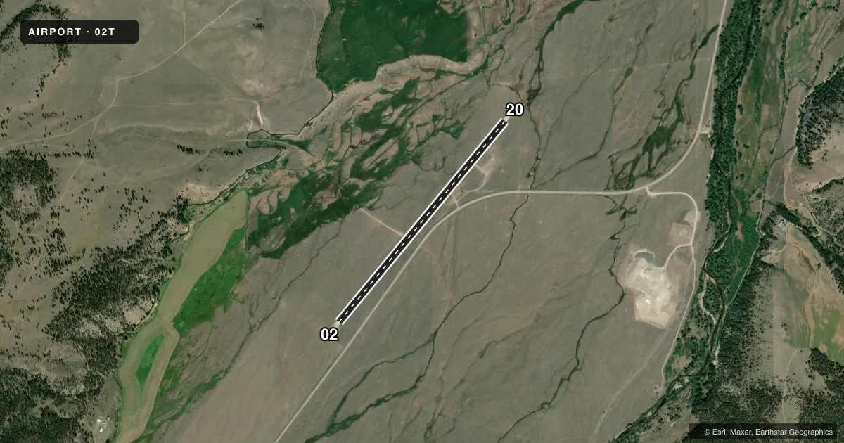
Runways & pattern
Full pagePattern entry · RWY 02
RIGHT TRAFFICAirport sketch
Runways drawn to scale from FAA survey coordinates, rendered over satellite imagery. Not for navigation.
Approaches & charts
Services on the field
Fuel grades, oxygen, maintenance, ramp storage and lighting — as declared to the FAA by the airport operator.
Fuel & services
- Fuel
- Not available
Ramp & ground
- Transient storage
- Tie-down
- Wind indicator
- Yes
- Segmented circle
- Yes
Fuel & FBOs
Cheapest 100LL and Jet A on the field and nearby. Always confirm with the FBO before taxi.
Airport notes
Surface conditions, obstructions, local procedures, lighting outages and other notes published with each FAA cycle.
General notes
- ARPT NOT PLOWED WINTER MONTHS.
- FOR CD CTC SALT LAKE ARTCC AT 801-320-2568.
Approach & departure obstructions
- 02RED CONES ON EACH RY END MARK THRESHOLDS.
Other notes
- PROVIDED ALL OPS VFR.
- 02/20RUTS AND GROOVES FM VEHICLE TFC ALG RWY.
VFR map & nearby airports
VFR sectional. Tap any ICAO chip to open that airport.
Key facts · 02T
Answer card- ICAO
- 02T
- Name
- WISE RIVER
- Location
- WISE RIVER, MONTANA
- Elevation
- 5,830 ft MSL
- Traffic pattern altitude
- 6,830 ft MSL (1,000 AGL)
- Control tower
- Non-towered (use CTAF)
- Total runways
- 1
- Longest runway
- 02/20 · 4,050 ft
- Published ILS approaches
- 0
- Published frequencies
- 1
- Magnetic variation
- 17°
- Current flight rules
- MVFR
- Current wind
- 130° at 5 kt
- Favored runway now
- RWY 02
Wise River Airport (02T) sits in Wise River, Montana. The field elevation is 5,830 ft MSL. It has one runway. Runway 02/20 is 4,050 ft long with a turf-dirt surface. The airport is not towered. CTAF is 122.9.
No ILS approaches are published here. All operations are under VFR. Pattern altitude is not published, so use the standard 1,000 ft AGL pattern unless the current Chart Supplement says otherwise. The published remarks also note red cones at each runway end to mark the thresholds. Vehicle traffic has left ruts and grooves along the runway. Winter snow removal is not provided, so plan for seasonal surface conditions and check the field before you go.
There are no on-field FBOs listed. Contact the airport operator directly or call the field on CTAF for current services before arrival. For clearance delivery, contact Salt Lake ARTCC at 801-320-2568. At this elevation, performance planning matters. The runway is short enough that density altitude and surface condition can change your takeoff and landing picture fast. If you are new to the strip, verify the current Chart Supplement before departure and expect a simple non-towered mountain airport with limited published instrument support.