METAR & TAF KDLN
Current METAR
Observed 10:53Z
KDLN 271053Z AUTO 22008KT 6SM HZ CLR 13/09 A3012 RMK AO2 SLP140 T01330094
- Wind
- 220° @ 8 kt
- Visibility
- 6 SM
- Temp / Dew
- 13°C / 9°C
- Altimeter
- 30.12 inHg
- Clouds
- CLR
- Density alt
- 6,015 ft
- Ceiling
- Unlimited
- Rules
- VFR
Airport info & contacts
Manager on record, flight service, ARTCC, attendance schedule and pattern altitude — published by the FAA and refreshed every 28 days.
Location
- From city
- 4 NM NE
- VFR sectional
- GREAT FALLS
- ARTCC
- ZLC · SALT LAKE CITY
- NOTAM facility
- DLN (NOTAM-D)
Airport manager
- Name
- JOSIAH JONES
- Phone
- 406-660-1873
- Address
- 2400 AIRPORT ROAD, DILLON MT 59725
Flight service · Hours
- FSS GTF
- GREAT FALLS1-800-WX-BRIEF
- Attendance
- 0800-1700
Frequencies
Tap any row to copy the frequency to your clipboard.
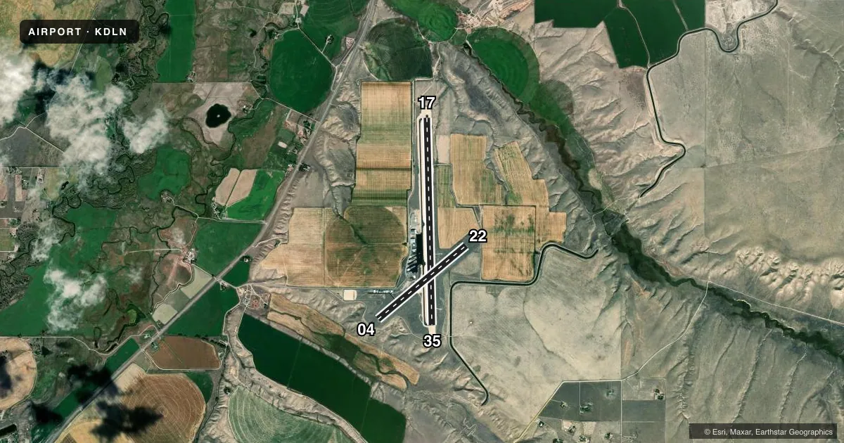
Runways & pattern
Full pagePattern entry · RWY 22
LEFT TRAFFIC| Runway | Heading (°M) | Length | Surface | Traffic |
|---|---|---|---|---|
| 17/35 | 166° / 346° | 6,501 ft | ASPH | Standard L |
| 04/22Favored | 37° / 217° | 3,600 ft | ASPH | Standard L |
Runway end performance
| End | TORA | TODA | ASDA | LDA | VGSI | Approach lights | Obstruction |
|---|---|---|---|---|---|---|---|
| 17 | — | — | — | — | PAPI 2-box left(3°) | — | — |
| 35 | — | — | — | — | PAPI 2-box left(3°) | — | — |
| 04 | — | — | — | — | — | — | 5', road, 254' from thr, 130' R of cntrln, slope 10 |
| 22 | — | — | — | — | PAPI 2-box left(3°) | — | 16', road, 450' from thr, 250' R of cntrln, slope 15 |
Declared distances in feet. TORA = takeoff run available, TODA = takeoff distance, ASDA = accelerate-stop, LDA = landing distance.
Airport sketch
Runways drawn to scale from FAA survey coordinates, rendered over satellite imagery. Not for navigation.
Approaches & charts
Services on the field
Fuel grades, oxygen, maintenance, ramp storage and lighting — as declared to the FAA by the airport operator.
Fuel & services
- Fuel
- 100LLAA+
- Airframe repair
- Not available
- Power plant repair
- Not available
Ramp & ground
- Transient storage
- Tie-down
- Hangar
- Landing fee
- Yes
- Customs
- Not available
- Lighting schedule
- SEE RMK
- Beacon schedule
- SS-SR
- Beacon
- White / Green (civil land)(WG)
- Wind indicator
- Lighted
- Segmented circle
- Yes
Fuel & FBOs
Cheapest 100LL and Jet A on the field and nearby. Always confirm with the FBO before taxi.
Airport notes
Surface conditions, obstructions, local procedures, lighting outages and other notes published with each FAA cycle.
General notes
- FOR CD IF UNA TO CTC ON FSS FREQ, CTC SALT LAKE ARTCC AT 801-320-2568.
- RWY VIS BLOCKED BY HNGRS & BLDGS; CFM OTR ACFT & OPS BFR TKOF.
Lighting notes
- ACTVT PAPI RWY 17, 22, & 35; MIRL RWY 04/22 & 17/35 - CTAF.
Runway surface & condition
- 17/35PCR VALUE: 328/F/D/X/T
Approach & departure obstructions
- 04DEP NA.
- 171000 FT DSTC MKRS.
- 351000 FT DSTC MKRS.
- 35PAPI UNUSBL BYD 5.0 NM.
Other notes
- 1AFT HR - AMGR OR 406-250-5280.
VFR map & nearby airports
VFR sectional. Tap any ICAO chip to open that airport.
Key facts · KDLN
Answer card- ICAO
- KDLN
- Name
- DILLON
- Location
- DILLON, MONTANA
- Elevation
- 5,244.7 ft MSL
- Traffic pattern altitude
- 6,244.7 ft MSL (1,000 AGL)
- Control tower
- Non-towered (use CTAF)
- Total runways
- 2
- Longest runway
- 17/35 · 6,501 ft
- Published ILS approaches
- 0
- Published frequencies
- 2
- Magnetic variation
- 13°
- Current flight rules
- VFR
- Current wind
- 220° at 8 kt
- Favored runway now
- RWY 22
Dillon Airport sits in Dillon, Montana at 5,244.7 ft MSL. It has two asphalt runways. The longest is 17/35 at 6,501 ft. The airport is not towered. CTAF and UNICOM are both 122.8. No ILS approaches are published here.
Pattern altitude is not published. Use the standard 1,000 ft AGL for light piston traffic unless the current Chart Supplement says otherwise. Dillon Flying Service is on the field. It carries 100LL and Jet A. After hours, the airport manager can be reached at 406-250-5280. Published remarks also note that runway visibility can be blocked by hangars and buildings. Confirm other traffic before takeoff. Runway 17 has distance markers every 1,000 ft. Runway 35 has the same markers. Medium intensity runway lights are available on both runways. PAPI is active on 17, 22 and 35. Departure from runway 04 is not authorized. This is a high-elevation field, so expect density altitude to matter, especially on warm days.