METAR & TAF 4U9
4U9 does not publish a METAR.
Showing the nearest reporting station: KDLN (DILLON) · 32.0 NM away. Conditions at 4U9 may differ.
METAR · KDLN
Observed 10:53Z
KDLN 271053Z AUTO 22008KT 6SM HZ CLR 13/09 A3012 RMK AO2 SLP140 T01330094
- Wind
- 220° @ 8 kt
- Visibility
- 6 SM
- Temp / Dew
- 13°C / 9°C
- Altimeter
- 30.12 inHg
- Clouds
- CLR
- Density alt
- 6,961 ft
- Ceiling
- Unlimited
- Rules
- VFR
Airport info & contacts
Manager on record, flight service, ARTCC, attendance schedule and pattern altitude — published by the FAA and refreshed every 28 days.
Location
- From city
- 1 NM NW
- VFR sectional
- GREAT FALLS
- ARTCC
- ZLC · SALT LAKE CITY
- NOTAM facility
- GTF (NOTAM-D)
Airport manager
- Name
- MIKE MARSH
- Phone
- 406-276-3340
- Address
- PO BOX 164, LIMA MT 59739-0507
Flight service · Hours
- FSS GTF
- GREAT FALLS1-800-WX-BRIEF
- Attendance
- Unattended
Frequencies
Tap any row to copy the frequency to your clipboard.
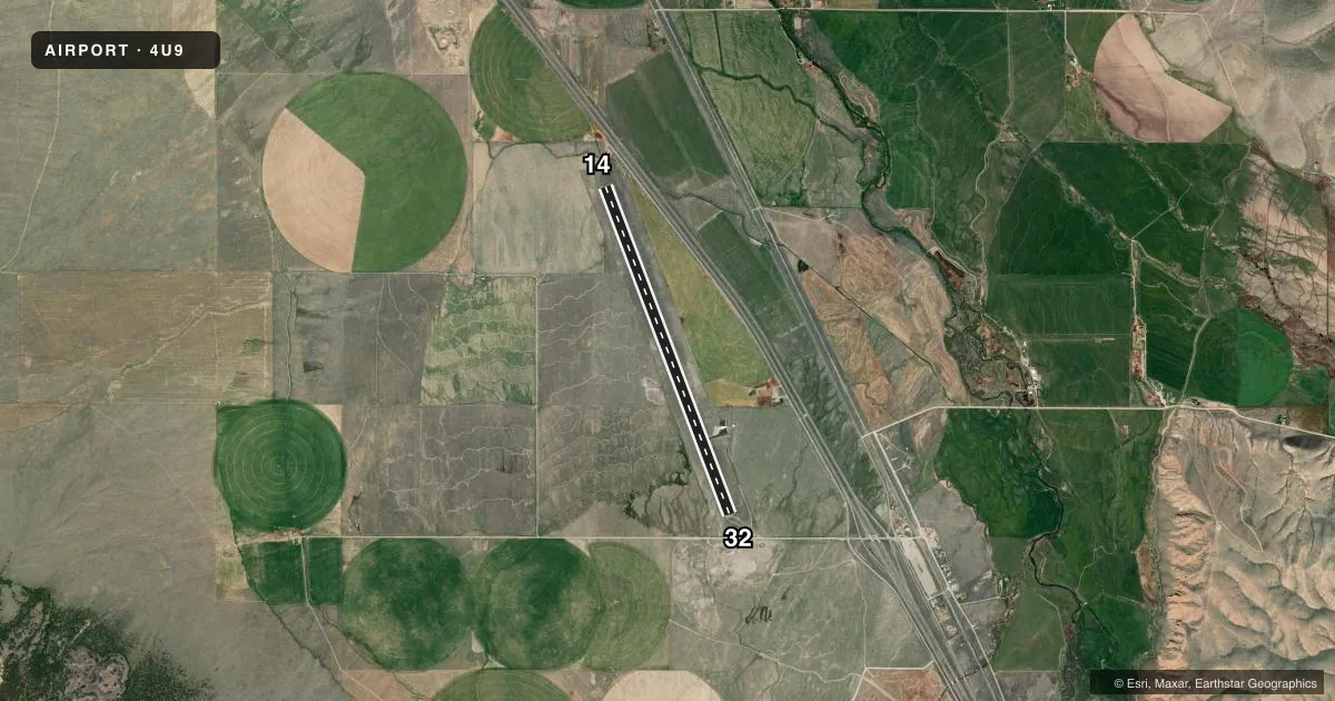
Runways & pattern
Full pagePattern entry · RWY 14
LEFT TRAFFICRunway end performance
| End | TORA | TODA | ASDA | LDA | VGSI | Approach lights | Obstruction |
|---|---|---|---|---|---|---|---|
| 14 | — | — | — | — | PAPI 2-box left(3.5°) | — | — |
| 32 | — | — | — | — | — | — | 17', road, 483' from thr, 0' R of cntrln, slope 16 |
Declared distances in feet. TORA = takeoff run available, TODA = takeoff distance, ASDA = accelerate-stop, LDA = landing distance.
Airport sketch
Runways drawn to scale from FAA survey coordinates, rendered over satellite imagery. Not for navigation.
Approaches & charts
Services on the field
Fuel grades, oxygen, maintenance, ramp storage and lighting — as declared to the FAA by the airport operator.
Fuel & services
- Fuel
- Not available
- Oxygen (bottled)
- Not available
- Oxygen (bulk)
- Not available
- Airframe repair
- Not available
- Power plant repair
- Not available
Ramp & ground
- Transient storage
- Tie-down
- Landing fee
- No fee published
- Lighting schedule
- SEE RMK
- Beacon schedule
- SS-SR
- Beacon
- White / Green (civil land)(WG)
- Wind indicator
- Yes
- Segmented circle
- No
Fuel & FBOs
Cheapest 100LL and Jet A on the field and nearby. Always confirm with the FBO before taxi.
Airport notes
Surface conditions, obstructions, local procedures, lighting outages and other notes published with each FAA cycle.
General notes
- SNOW REMOVAL IRREGULAR.
- DEER ON & INVOF ARPT.
- FOR CD CTC SALT LAKE ARTCC AT 801-320-2568.
Lighting notes
- ACTVT MIRL RY 14/32 & PAPI RY 14 - CTAF.
Other notes
- 14/32LARGE CRACKS WITH PROTRUDING WEEDS THROUGHOUT RY SFC.
VFR map & nearby airports
VFR sectional. Tap any ICAO chip to open that airport.
Key facts · 4U9
Answer card- ICAO
- 4U9
- Name
- DELL FLIGHT STRIP
- Location
- DELL, MONTANA
- Elevation
- 6,007 ft MSL
- Traffic pattern altitude
- 7,007 ft MSL (1,000 AGL)
- Control tower
- Non-towered (use CTAF)
- Total runways
- 1
- Longest runway
- 14/32 · 7,000 ft
- Published ILS approaches
- 0
- Published frequencies
- 1
- Magnetic variation
- 16°
- Current flight rules
- VFR
- Current wind
- 220° at 8 kt
- Favored runway now
- RWY 14
DELL FLIGHT STRIP (4U9) sits near Dell, Montana. The field elevation is 6,007 ft MSL. It has one runway, 14/32, which is 7,000 ft long and asphalt. There is no control tower. CTAF is 122.9.
No ILS approaches are published here. The pattern altitude is not published, so use the standard 1,000 ft AGL for light piston traffic unless the current Chart Supplement says otherwise. Medium intensity runway lights are installed on 14/32. The PAPI for runway 14 is controlled on CTAF. For clearance delivery, contact Salt Lake ARTCC at 801-320-2568.
This is a high-elevation strip, so performance planning matters. Expect the thinner air at 6,007 ft MSL to affect takeoff and climb. Published remarks also note deer on and near the airport. Snow removal is irregular. The runway surface has large cracks with protruding weeds throughout, so a careful surface check is smart before landing. No on-field FBOs are listed, so verify fuel and services with the airport operator or the field by phone before arrival.