METAR & TAF 1U2
1U2 does not publish a METAR.
Showing the nearest reporting station: KIDA (IDAHO FALLS RGNL) · 27.6 NM away. Conditions at 1U2 may differ.
METAR · KIDA
Observed 09:53Z
KIDA 270953Z AUTO 22013KT 6SM HZ CLR 23/06 A3005 RMK AO2 LTG DSNT SE SLP112 T02330061
- Wind
- 220° @ 13 kt
- Visibility
- 6 SM
- Temp / Dew
- 23°C / 6°C
- Altimeter
- 30.05 inHg
- Clouds
- CLR
- Density alt
- 6,745 ft
- Ceiling
- Unlimited
- Rules
- VFR
Airport info & contacts
Manager on record, flight service, ARTCC, attendance schedule and pattern altitude — published by the FAA and refreshed every 28 days.
Location
- From city
- 1 NM NW
- VFR sectional
- SALT LAKE CITY
- ARTCC
- ZLC · SALT LAKE CITY
- NOTAM facility
- BOI (NOTAM-D)
Airport manager
- Phone
- 208-663-4840
- Address
- 1583N 1000 E, MUD LAKE ID 83450
Flight service · Hours
- FSS BOI
- BOISE1-800-WX-BRIEF
- Attendance
- MAY-OCT · 0800-1700
- NOV-APR · IREG · IREG
Frequencies
Tap any row to copy the frequency to your clipboard.
Runways & pattern
Full pagePattern entry · RWY 22
LEFT TRAFFICRunway end performance
| End | TORA | TODA | ASDA | LDA | VGSI | Approach lights | Obstruction |
|---|---|---|---|---|---|---|---|
| 04 | — | — | — | — | — | — | 5', fence, 290' from thr, 0' R of cntrln, slope 18 |
| 22 | — | — | — | — | — | — | 12', road, 250' from thr, 150' R of cntrln, slope 4 |
Declared distances in feet. TORA = takeoff run available, TODA = takeoff distance, ASDA = accelerate-stop, LDA = landing distance.
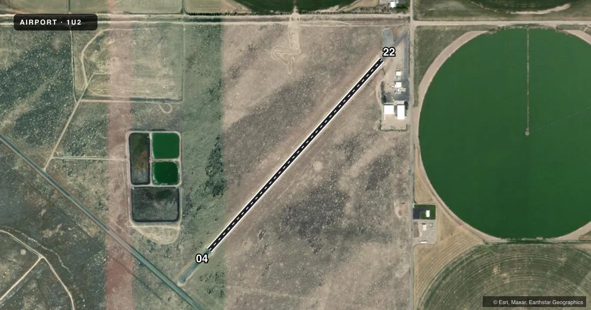
Airport sketch
Runways drawn to scale from FAA survey coordinates, rendered over satellite imagery. Not for navigation.
Approaches & charts
Services on the field
Fuel grades, oxygen, maintenance, ramp storage and lighting — as declared to the FAA by the airport operator.
Fuel & services
- Fuel
- Not available
- Oxygen (bottled)
- Not available
- Oxygen (bulk)
- Not available
- Airframe repair
- Major
- Power plant repair
- Major
- Other services
- AGRI
Ramp & ground
- Transient storage
- Tie-down
- Landing fee
- No fee published
- Lighting schedule
- SS-SR
- Beacon schedule
- SS-SR
- Beacon
- White / Green (civil land)(WG)
- Wind indicator
- Yes
- Segmented circle
- Yes
Fuel & FBOs
Cheapest 100LL and Jet A on the field and nearby. Always confirm with the FBO before taxi.
Airport notes
Surface conditions, obstructions, local procedures, lighting outages and other notes published with each FAA cycle.
General notes
- NGT OPS RECOMMENDED ONLY TO PLTS FAMILIAR WITH ARPT APCHS AND SURROUNDING TERRAIN.
- LIRL RWY 22 & ROTG BCN INOP EACH YEAR FM 1 NOV - 1 APR.
- CFM SN REMOVAL & WINT COND WITH AMGR: 208-663-4840.
- EMERG FUEL SVC ONLY (JET-A & 100LL). CALL AMGR AT 208-663-4840.
- FOR CD CTC SALT LAKE ARTCC AT 801-320-2568.
Runway surface & condition
- 04/22LOW INTST THR LGTS RWY 22; FST 600 FT RWY HAS LOW INTST EDGE LGTS; RMNG 2700 FT OF RWY ILLUMINATED WITH SOLAR LGTS.
Approach & departure obstructions
- 0417 FT HWY AT 80 FT ON CNTRLN, FM END OF PAVEMENT.
- 0417 FT ROAD AT 580 FT, 33:1 FM THR.
- 22THR 450 FT FM 15 FT ROAD. 22:1 SLP FM THR.
- 22ADDNL OBSTN: 12 FT STOP SIGN AT 540 FT ON CNTRLN, +40 FT POLE AT 650 FT, 130 FT RIGHT FM EXTDD CNTRLN.
VFR map & nearby airports
VFR sectional. Tap any ICAO chip to open that airport.
Key facts · 1U2
Answer card- ICAO
- 1U2
- Name
- MUD LAKE/WEST JEFFERSON COUNTY
- Location
- MUD LAKE, IDAHO
- Elevation
- 4,795 ft MSL
- Traffic pattern altitude
- 5,795 ft MSL (1,000 AGL)
- Control tower
- Non-towered (use CTAF)
- Total runways
- 1
- Longest runway
- 04/22 · 2,950 ft
- Published ILS approaches
- 0
- Published frequencies
- 1
- Magnetic variation
- 16°
- Current flight rules
- VFR
- Current wind
- 220° at 13 kt
- Favored runway now
- RWY 22
MUD LAKE/WEST JEFFERSON COUNTY (1U2) sits at Mud Lake, Idaho. Field elevation is 4,795 ft MSL. The airport has one runway, 04/22, which is 2,950 ft long and asphalt. There is no control tower. CTAF is 122.9. No ILS approaches are published here.
Pattern altitude is not published. Use the standard 1,000 ft AGL pattern unless the current Chart Supplement or local procedures say otherwise. That puts the light piston pattern at about 5,795 ft MSL. Magnetic variation is 16°, so runway headings are magnetic. The field is a simple one-runway airport, but the published remarks matter. Runway 22 has low intensity threshold lights. The first 600 ft of runway 22 has low intensity edge lights. The remaining 2,700 ft is lit with solar lights. Low intensity runway lights on runway 22 and the rotating beacon are inoperative each year from November 1 to April 1.
There are no on-field FBOs listed. Emergency fuel service is available only for Jet-A and 100LL. Call the airport manager at 208-663-4840 to confirm snow removal and winter conditions before you go. The published obstructions near both runway ends deserve attention. Night operations are recommended only for pilots familiar with the airport approaches and surrounding terrain. Clearance delivery can be handled through Salt Lake ARTCC at 801-320-2568.