METAR & TAF U37
U37 does not publish a METAR.
Showing the nearest reporting station: KIDA (IDAHO FALLS RGNL) · 32.3 NM away. Conditions at U37 may differ.
METAR · KIDA
Observed 03:53Z
KIDA 270353Z AUTO 00000KT 10SM CLR 26/13 A3002 RMK AO2 SLP108 T02560133
- Wind
- 000° @ 0 kt
- Visibility
- 10 SM
- Temp / Dew
- 26°C / 13°C
- Altimeter
- 30.02 inHg
- Clouds
- CLR
- Density alt
- 7,417 ft
- Ceiling
- Unlimited
- Rules
- VFR
Airport info & contacts
Manager on record, flight service, ARTCC, attendance schedule and pattern altitude — published by the FAA and refreshed every 28 days.
Location
- From city
- 1 NM NE
- VFR sectional
- SALT LAKE CITY
- ARTCC
- ZLC · SALT LAKE CITY
- NOTAM facility
- BOI (NOTAM-D)
Airport manager
- Name
- ITD/DIV. OF AERONAUTICS
- Phone
- 208-334-8775
- Address
- P.O. BOX 7129, BOISE ID 83707-1129
Flight service · Hours
- FSS BOI
- BOISE1-800-WX-BRIEF
- Attendance
- Unattended
Frequencies
Tap any row to copy the frequency to your clipboard.
Runways & pattern
Full pagePattern entry · RWY 02
LEFT TRAFFICRunway end performance
| End | TORA | TODA | ASDA | LDA | VGSI | Approach lights | Obstruction |
|---|---|---|---|---|---|---|---|
| 02 | — | — | — | — | — | — | 15', road, 0' from thr, 100' R of cntrln, slope 0 |
| 20 | — | — | — | — | — | — | 17', road, 270' from thr, 0' R of cntrln, slope 15 |
Declared distances in feet. TORA = takeoff run available, TODA = takeoff distance, ASDA = accelerate-stop, LDA = landing distance.
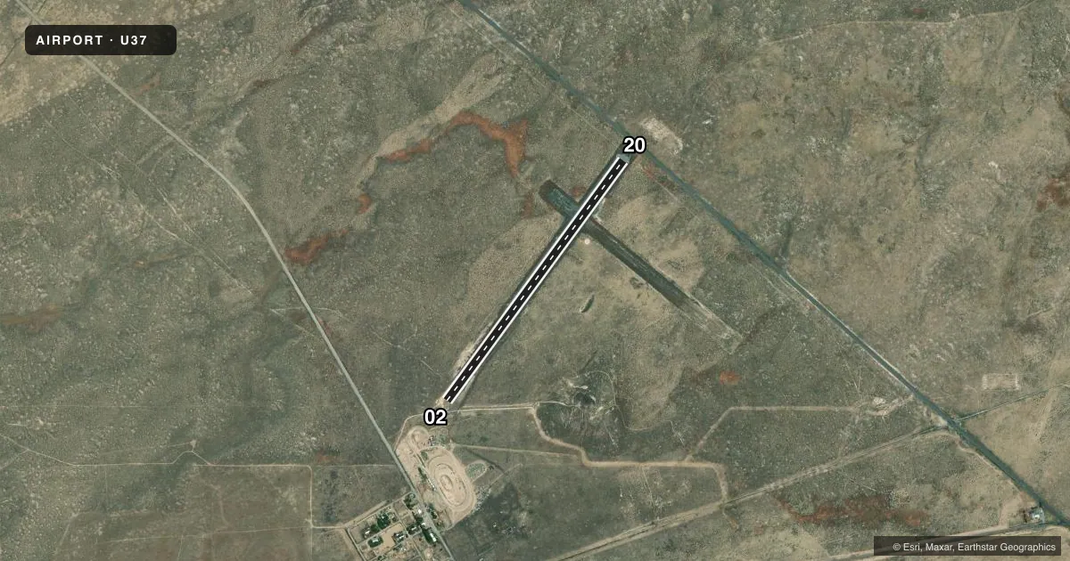
Airport sketch
Runways drawn to scale from FAA survey coordinates, rendered over satellite imagery. Not for navigation.
Approaches & charts
Services on the field
Fuel grades, oxygen, maintenance, ramp storage and lighting — as declared to the FAA by the airport operator.
Fuel & services
- Fuel
- Not available
- Oxygen (bottled)
- Not available
- Oxygen (bulk)
- Not available
- Airframe repair
- Not available
- Power plant repair
- Not available
Ramp & ground
- Transient storage
- Tie-down
- Landing fee
- No fee published
- Customs
- Not available
- Wind indicator
- Yes
- Segmented circle
- Yes
Fuel & FBOs
Cheapest 100LL and Jet A on the field and nearby. Always confirm with the FBO before taxi.
Airport notes
Surface conditions, obstructions, local procedures, lighting outages and other notes published with each FAA cycle.
General notes
- NO WINTER MAINT.
- +8 FT HVY SAGEBRUSH ON FNA TO RWY 20 & +5 FT SAGEBRUSH ON BOTH RWY EDGES.
- FOR CD CTC SALT LAKE ARTCC AT 801-320-2568.
Approach & departure obstructions
- 0202/20 EDGES & THRS MARKED WITH WHITE ROCKS.
- 0215 FT DIRT ROAD PARLS THE RWY AT 0 FT, 100 FT RIGHT, FOR A FEW HND FEET USED BY RV TRAILERS AND FARM EQPT.
Other notes
- ESTABD PRIOR TO 1959.
- 02/20FIRST 1500 FT RWY 02 IS SOFT DUE TO MIXED DIRT & CRUSHED RED LAVA ROCK; REMAINDER OF RWY GRVL.
VFR map & nearby airports
VFR sectional. Tap any ICAO chip to open that airport.
Key facts · U37
Answer card- ICAO
- U37
- Name
- MIDWAY
- Location
- ATOMIC CITY, IDAHO
- Elevation
- 5,017 ft MSL
- Traffic pattern altitude
- 6,017 ft MSL (1,000 AGL)
- Control tower
- Non-towered (use CTAF)
- Total runways
- 1
- Longest runway
- 02/20 · 3,800 ft
- Published ILS approaches
- 0
- Published frequencies
- 1
- Magnetic variation
- 16°
- Current flight rules
- VFR
- Current wind
- 000° at 0 kt
- Favored runway now
- –
Midway (U37) is in Atomic City, Idaho. The field elevation is 5,017 ft MSL. It has one runway, 02/20 and the longest runway is 3,800 ft. The airport is non-towered. CTAF is 122.9. No ILS approaches are published here.
The pattern altitude is not published. Use 6,017 ft MSL as the standard 1,000 ft AGL reference for light piston traffic. Then verify the current Chart Supplement before you go. The runway surface is gravel. The first 1,500 ft of runway 02 is dirt mixed with crushed red lava rock. The rest is gravel. White rocks mark the runway edges and thresholds. There is sagebrush over 8 ft high on final to runway 20. Sagebrush over 5 ft high lines both runway edges.
No on-field FBOs are listed. No winter maintenance is provided. That matters here. Expect a rougher surface in cold weather and plan for the lack of runway clearing. For clearance delivery, contact Salt Lake ARTCC at 801-320-2568. This is a high-elevation strip with a gravel surface. Density altitude will matter. Check the current Chart Supplement and call the airport operator or the field directly before arrival if you need current operational details.