METAR & TAF U02
U02 does not publish a METAR.
Showing the nearest reporting station: KPIH (POCATELLO RGNL) · 21.0 NM away. Conditions at U02 may differ.
METAR · KPIH
Observed 11:53Z
KPIH 271153Z 22007KT 4SM HZ CLR 22/03 A3004 RMK AO2 SLP106 T02220033 10289 20217 51004
- Wind
- 220° @ 7 kt
- Visibility
- 4 SM
- Temp / Dew
- 22°C / 3°C
- Altimeter
- 30.04 inHg
- Clouds
- CLR
- Density alt
- 6,261 ft
- Ceiling
- Unlimited
- Rules
- MVFR
Airport info & contacts
Manager on record, flight service, ARTCC, attendance schedule and pattern altitude — published by the FAA and refreshed every 28 days.
Location
- From city
- 1 NM N
- VFR sectional
- SALT LAKE CITY
- ARTCC
- ZLC · SALT LAKE CITY
- NOTAM facility
- BOI (NOTAM-D)
Airport manager
- Name
- RANDY WAREING
- Phone
- (208) 709-9719
- Address
- 1311 AIRPORT RD., BLACKFOOT ID 83221
Flight service · Hours
- FSS BOI
- BOISE1-800-WX-BRIEF
- Attendance
- MON-SAT · 0800-1700
Frequencies
Tap any row to copy the frequency to your clipboard.
Runways & pattern
Full pagePattern entry · RWY 19
LEFT TRAFFICRunway end performance
| End | TORA | TODA | ASDA | LDA | VGSI | Approach lights | Obstruction |
|---|---|---|---|---|---|---|---|
| 01 | — | — | — | — | PAPI 2-box left(3°) | — | 6', fence, 200' from thr, 110' R of cntrln, slope 0 |
| 19 | — | — | — | — | PAPI 2-box left(3.25°) | — | 40', tree, 700' from thr, 0' R of cntrln, slope 12 |
Declared distances in feet. TORA = takeoff run available, TODA = takeoff distance, ASDA = accelerate-stop, LDA = landing distance.
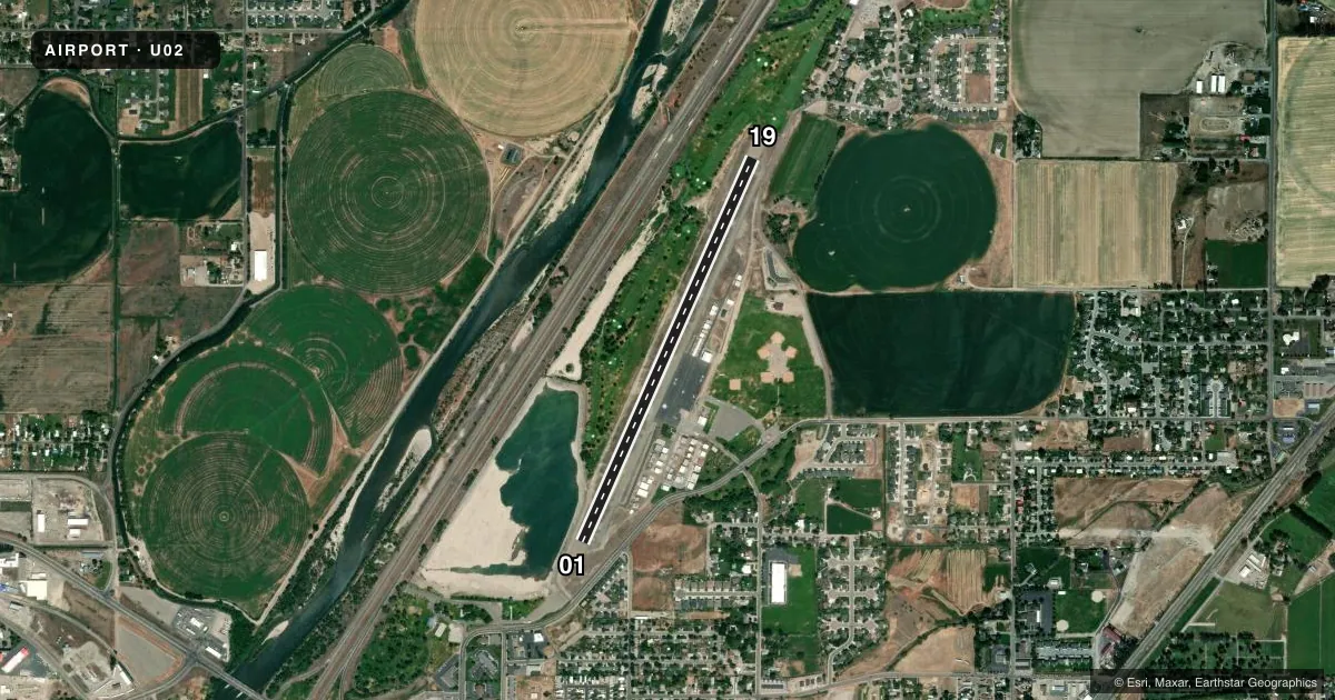
Airport sketch
Runways drawn to scale from FAA survey coordinates, rendered over satellite imagery. Not for navigation.
Approaches & charts
Services on the field
Fuel grades, oxygen, maintenance, ramp storage and lighting — as declared to the FAA by the airport operator.
Fuel & services
- Fuel
- 100LL
- Oxygen (bottled)
- Not available
- Oxygen (bulk)
- Not available
- Airframe repair
- Minor
- Power plant repair
- Major
- Other services
- AGRI,INSTR
Ramp & ground
- Transient storage
- Tie-down
- Landing fee
- No fee published
- Customs
- Not available
- Lighting schedule
- SS-SR
- Beacon schedule
- SS-SR
- Beacon
- White / Green (civil land)(WG)
- Wind indicator
- Lighted
- Segmented circle
- Yes
Fuel & FBOs
Cheapest 100LL and Jet A on the field and nearby. Always confirm with the FBO before taxi.
Airport notes
Surface conditions, obstructions, local procedures, lighting outages and other notes published with each FAA cycle.
General notes
- CONSIDERABLE AG OPERATIONS DURING GROWING SEASON.
- BIRD ACTIVITY ON AND INVOF RY 01 THRESHOLD.
- FOR CD CTC SALT LAKE ARTCC AT 801-320-2568.
Approach & departure obstructions
- 01RWY 01 HAS +6 FT FENCE AT 0 FT, 120 FT L.
- 19RWY 01 PAPI SYS IS INOP.
Other notes
- ESTABD PRIOR TO 15 MAY 1959.
VFR map & nearby airports
VFR sectional. Tap any ICAO chip to open that airport.
Key facts · U02
Answer card- ICAO
- U02
- Name
- MCCARLEY FLD
- Location
- BLACKFOOT, IDAHO
- Elevation
- 4,491.6 ft MSL
- Traffic pattern altitude
- 5,491.6 ft MSL (1,000 AGL)
- Control tower
- Non-towered (use CTAF)
- Total runways
- 1
- Longest runway
- 01/19 · 4,314 ft
- Published ILS approaches
- 0
- Published frequencies
- 2
- Magnetic variation
- 15°
- Current flight rules
- MVFR
- Current wind
- 220° at 7 kt
- Favored runway now
- RWY 19
McCarley Fld sits in Blackfoot, Idaho. The field elevation is 4,491.6 ft MSL. It has one runway. Runway 01/19 is 4,314 ft long with asphalt pavement. The airport is non-towered. CTAF and UNICOM are both 122.8.
No ILS approaches are published here. Pattern altitude is not published, so verify the current Chart Supplement before you fly. McCarley Field is on the field and carries 100LL. Call (208) 785-8600 for current service details.
A few published remarks matter for planning. Bird activity is present near the runway 01 threshold. Runway 01 also has a fence over 6 feet tall located 120 feet left of the centerline at the threshold. The runway 01 PAPI is inoperative. Clearance delivery is handled through Salt Lake ARTCC at 801-320-2568. Agricultural activity picks up during the growing season, so expect more low-level traffic and field work nearby. With the elevation here, performance planning matters on warm days. Check density altitude before departure and give yourself margin.