METAR & TAF U01
U01 does not publish a METAR.
Showing the nearest reporting station: KPIH (POCATELLO RGNL) · 12.1 NM away. Conditions at U01 may differ.
METAR · KPIH
Observed 12:53Z
KPIH 271253Z 23006KT 3SM HZ CLR 23/03 A3005 RMK AO2 SLP109 T02280033
- Wind
- 230° @ 6 kt
- Visibility
- 3 SM
- Temp / Dew
- 23°C / 3°C
- Altimeter
- 30.05 inHg
- Clouds
- CLR
- Density alt
- 6,280 ft
- Ceiling
- Unlimited
- Rules
- MVFR
Airport info & contacts
Manager on record, flight service, ARTCC, attendance schedule and pattern altitude — published by the FAA and refreshed every 28 days.
Location
- From city
- 2 NM NE
- VFR sectional
- SALT LAKE CITY
- ARTCC
- ZLC · SALT LAKE CITY
- NOTAM facility
- BOI (NOTAM-D)
Airport manager
- Name
- DALLEN WARD
- Phone
- 208-223-6276
- Address
- 5203 MOHAWK, POCATELLO ID 83204-5401
Flight service · Hours
- FSS BOI
- BOISE1-800-WX-BRIEF
- Attendance
- 0800-1800
Frequencies
Tap any row to copy the frequency to your clipboard.
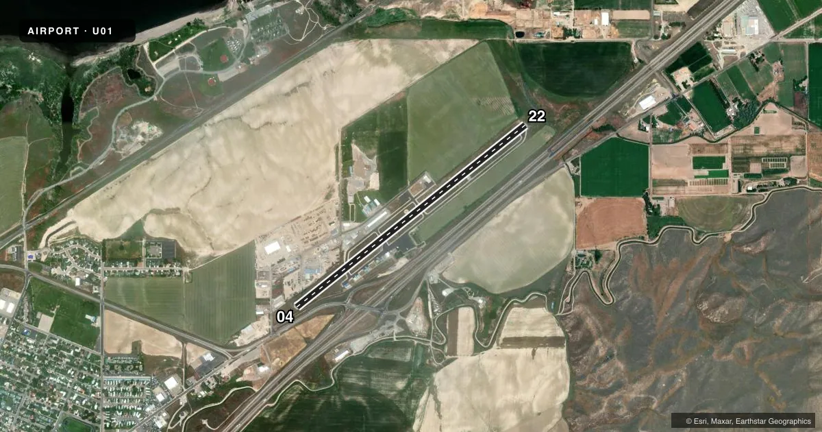
Runways & pattern
Full pagePattern entry · RWY 22
LEFT TRAFFICRunway end performance
| End | TORA | TODA | ASDA | LDA | VGSI | Approach lights | Obstruction |
|---|---|---|---|---|---|---|---|
| 04 | — | — | — | — | — | — | 4', fence, 200' from thr, 30' R of cntrln, slope 0 |
| 22 | — | — | — | — | PAPI 2-box left(3.5°) | — | 15', trees, 315' from thr, 0' R of cntrln, slope 7 |
Declared distances in feet. TORA = takeoff run available, TODA = takeoff distance, ASDA = accelerate-stop, LDA = landing distance.
Airport sketch
Runways drawn to scale from FAA survey coordinates, rendered over satellite imagery. Not for navigation.
Approaches & charts
Services on the field
Fuel grades, oxygen, maintenance, ramp storage and lighting — as declared to the FAA by the airport operator.
Fuel & services
- Fuel
- 100LL
- Other services
- INSTR
Ramp & ground
- Transient storage
- Tie-down
- Landing fee
- No fee published
- Customs
- Not available
- Lighting schedule
- SEE RMK
- Beacon schedule
- SS-SR
- Beacon
- White / Green (civil land)(WG)
- Wind indicator
- Lighted
- Segmented circle
- No
Fuel & FBOs
Cheapest 100LL and Jet A on the field and nearby. Always confirm with the FBO before taxi.
Airport notes
Surface conditions, obstructions, local procedures, lighting outages and other notes published with each FAA cycle.
General notes
- FQT HEL OPS YEAR ARND.
- IREG SN REMOVAL.
- FOR CD CTC SALT LAKE ARTCC AT 801-320-2568.
Lighting notes
- ACTVT REIL RWY 22; PAPI RWY 22 ; MIRL RWY 04/22 - CTAF.
Approach & departure obstructions
- 04HAS 4 FT FENCE 0 FT FM THLD AND 30 FT R.
Other notes
- ESTABD PRIOR TO 1959.
VFR map & nearby airports
VFR sectional. Tap any ICAO chip to open that airport.
Key facts · U01
Answer card- ICAO
- U01
- Name
- SAVAGE FLD
- Location
- AMERICAN FALLS, IDAHO
- Elevation
- 4,420.2 ft MSL
- Traffic pattern altitude
- 5,420.2 ft MSL (1,000 AGL)
- Control tower
- Non-towered (use CTAF)
- Total runways
- 1
- Longest runway
- 04/22 · 4,900 ft
- Published ILS approaches
- 0
- Published frequencies
- 2
- Magnetic variation
- 16°
- Current flight rules
- MVFR
- Current wind
- 230° at 6 kt
- Favored runway now
- RWY 22
Savage Fld is in American Falls, Idaho. The field elevation is 4,420.2 ft MSL. It has one runway. Runway 04/22 is 4,900 ft of asphalt, which is the longest runway on the field. There is no control tower. CTAF and UNICOM are both 122.8. No ILS approaches are published here.
The pattern altitude is not published. Use the standard 1,000 ft AGL unless the current Chart Supplement says otherwise. That puts the traffic pattern at about 5,420.2 ft MSL based on the field elevation. Runway 22 has REILs and a PAPI. Runways 04 and 22 have medium intensity runway lights. Runway 04 has a fence near the threshold on the right side. Keep that in mind on short final.
Savage Field is the on-field FBO. It carries AVGAS 100LL. Frequent helicopter operations happen year-round, so expect mixed traffic. Snow removal can be irregular. If you need clearance delivery, contact Salt Lake ARTCC at 801-320-2568. For a first-time arrival, plan for density altitude, watch the obstacle near Runway 04 and verify current field conditions before you launch in winter.