METAR & TAF U36
U36 does not publish a METAR.
Showing the nearest reporting station: KPIH (POCATELLO RGNL) · 12.5 NM away. Conditions at U36 may differ.
METAR · KPIH
Observed 20:53Z
KPIH 262053Z 31008KT 10SM SCT060 35/07 A3003 RMK AO2 SLP102 T03500067 56019
- Wind
- 310° @ 8 kt
- Visibility
- 10 SM
- Temp / Dew
- 35°C / 7°C
- Altimeter
- 30.03 inHg
- Clouds
- SCT
- Density alt
- 7,811 ft
- Ceiling
- Unlimited
- Rules
- VFR
Airport info & contacts
Manager on record, flight service, ARTCC, attendance schedule and pattern altitude — published by the FAA and refreshed every 28 days.
Location
- From city
- 2 NM SW
- VFR sectional
- SALT LAKE CITY
- ARTCC
- ZLC · SALT LAKE CITY
- NOTAM facility
- BOI (NOTAM-D)
Airport manager
- Name
- ROBERT GOSS
- Phone
- 208-244-1885
- Address
- P.O. BOX 190, ABERDEEN ID 83210
Flight service · Hours
- FSS BOI
- BOISE1-800-WX-BRIEF
- Attendance
- JAN-DEC · MON-SUN · DALGT
Frequencies
Tap any row to copy the frequency to your clipboard.
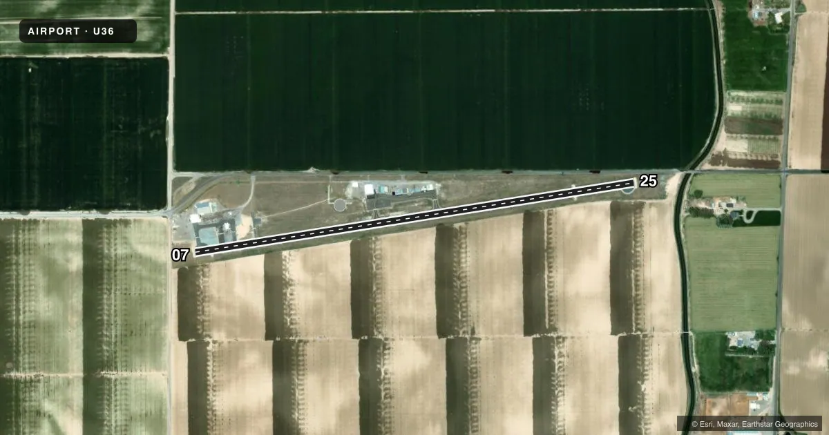
Runways & pattern
Full pagePattern entry · RWY 25
LEFT TRAFFICRunway end performance
| End | TORA | TODA | ASDA | LDA | VGSI | Approach lights | Obstruction |
|---|---|---|---|---|---|---|---|
| 07 | 3,690' | 3,690' | 3,466' | 3,324' | — | — | 15', road, 210' from thr, 0' R of cntrln, slope 0 |
| 25 | 3,458' | 3,458' | 3,624' | 3,112' | — | — | 4', fence, 200' from thr, 60' R of cntrln, slope 0 |
Declared distances in feet. TORA = takeoff run available, TODA = takeoff distance, ASDA = accelerate-stop, LDA = landing distance.
Airport sketch
Runways drawn to scale from FAA survey coordinates, rendered over satellite imagery. Not for navigation.
Approaches & charts
Services on the field
Fuel grades, oxygen, maintenance, ramp storage and lighting — as declared to the FAA by the airport operator.
Fuel & services
- Fuel
- Not available
- Oxygen (bottled)
- Not available
- Oxygen (bulk)
- Not available
- Other services
- AGRI
Ramp & ground
- Transient storage
- Tie-down
- Landing fee
- No fee published
- Customs
- Not available
- Lighting schedule
- SEE RMK
- Beacon schedule
- SS-SR
- Beacon
- White / Green (civil land)(WG)
- Wind indicator
- Lighted
- Segmented circle
- Yes
Fuel & FBOs
Cheapest 100LL and Jet A on the field and nearby. Always confirm with the FBO before taxi.
Airport notes
Surface conditions, obstructions, local procedures, lighting outages and other notes published with each FAA cycle.
General notes
- IREG WINTER MAINTENANCE.
- CONSIDERABLE AGRICULTURE OPS DURING GROWING SEASON.
- +30 FT SPRINKLER AND TERRAIN AT 230 FT FM SW END OF RY MAY BE IN POSITION.
- FOR CD CTC SALT LAKE ARTCC AT 801-320-2568.
Lighting notes
- ACTVT MIRL RY 07/25 - CTAF.
Approach & departure obstructions
- 07+4' FENCE AT 0', 100' RIGHT.
- 254 FT FENCE AT 0 FT, 150 FT R. +15 FT ROAD AT 0 FT, 160 FT R.
- 074 FT BARB WIRE FENCE AT 0 FT, 60 FT L.
- 0715 FT ROAD AT 210 FT, ON CNTRLN.
- 25+60 FT TREE AT 550 FT; 100 FT L.
Other notes
- ESTABD PRIOR TO 15 MAY 1959.
VFR map & nearby airports
VFR sectional. Tap any ICAO chip to open that airport.
Key facts · U36
Answer card- ICAO
- U36
- Name
- ABERDEEN MUNI
- Location
- ABERDEEN, IDAHO
- Elevation
- 4,473.5 ft MSL
- Traffic pattern altitude
- 5,473.5 ft MSL (1,000 AGL)
- Control tower
- Non-towered (use CTAF)
- Total runways
- 1
- Longest runway
- 07/25 · 3,690 ft
- Published ILS approaches
- 0
- Published frequencies
- 1
- Magnetic variation
- 16°
- Current flight rules
- VFR
- Current wind
- 310° at 8 kt
- Favored runway now
- RWY 25
Aberdeen Muni sits in Aberdeen, Idaho. The field elevation is 4,473.5 ft MSL. It has one runway, 07/25, which is 3,690 ft long. There is no control tower. CTAF is 122.9.
No ILS approaches are published here. Pattern altitude is not published, so use the standard 1,000 ft AGL pattern unless the current Chart Supplement says otherwise. That puts the light piston pattern at about 5,473.5 ft MSL. The airport is in a high-elevation part of Idaho, so performance planning matters. Expect thinner air. Plan your takeoff and landing numbers with some margin.
The published remarks matter here. Medium intensity runway lights on 07/25 are activated by CTAF. Agricultural activity is common during the growing season. There are several runway-end and near-runway obstructions listed, including fences, a road, a tree near the 25 end and a sprinkler or terrain feature that may be in position. Winter maintenance is irregular, so check surface condition before you go. No on-field FBOs are listed. Contact the airport operator directly before arrival, or call the field on CTAF for current fuel and service availability.