METAR & TAF 2U4
2U4 does not publish a METAR.
Showing the nearest reporting station: KPIH (POCATELLO RGNL) · 17.0 NM away. Conditions at 2U4 may differ.
METAR · KPIH
Observed 11:53Z
KPIH 271153Z 22007KT 4SM HZ CLR 22/03 A3004 RMK AO2 SLP106 T02220033 10289 20217 51004
- Wind
- 220° @ 7 kt
- Visibility
- 4 SM
- Temp / Dew
- 22°C / 3°C
- Altimeter
- 30.04 inHg
- Clouds
- CLR
- Density alt
- 6,228 ft
- Ceiling
- Unlimited
- Rules
- MVFR
Airport info & contacts
Manager on record, flight service, ARTCC, attendance schedule and pattern altitude — published by the FAA and refreshed every 28 days.
Location
- From city
- 0 NM E
- VFR sectional
- SALT LAKE CITY
- ARTCC
- ZLC · SALT LAKE CITY
- NOTAM facility
- BOI (NOTAM-D)
Airport manager
- Name
- SCOTT REESE
- Phone
- (208) 782-3190
- Address
- P O BOX 206, BLACKFOOT ID 83221
Flight service · Hours
- FSS BOI
- BOISE1-800-WX-BRIEF
- Attendance
- Unattended
Frequencies
Tap any row to copy the frequency to your clipboard.
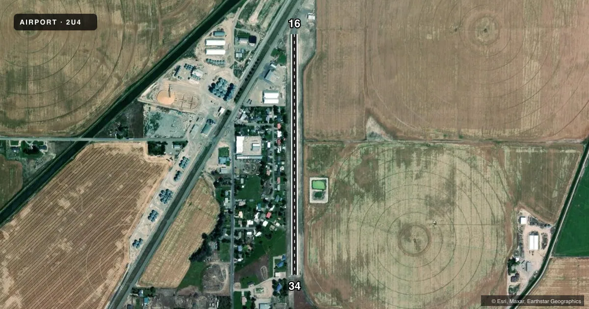
Runways & pattern
Full pagePattern entry · RWY 16
LEFT TRAFFICRunway end performance
| End | TORA | TODA | ASDA | LDA | VGSI | Approach lights | Obstruction |
|---|---|---|---|---|---|---|---|
| 16 | — | — | — | — | — | — | 23', rr, 225' from thr, 125' R of cntrln, slope 1 |
| 34 | — | — | — | — | — | — | 40', tree, 400' from thr, 30' R of cntrln, slope 5 |
Declared distances in feet. TORA = takeoff run available, TODA = takeoff distance, ASDA = accelerate-stop, LDA = landing distance.
Airport sketch
Runways drawn to scale from FAA survey coordinates, rendered over satellite imagery. Not for navigation.
Approaches & charts
Services on the field
Fuel grades, oxygen, maintenance, ramp storage and lighting — as declared to the FAA by the airport operator.
Fuel & services
- Fuel
- Not available
- Oxygen (bottled)
- Not available
- Oxygen (bulk)
- Not available
- Airframe repair
- Not available
- Power plant repair
- Not available
Ramp & ground
- Transient storage
- Tie-down
- Buoy
- Landing fee
- No fee published
- Wind indicator
- Yes
- Segmented circle
- No
Fuel & FBOs
Cheapest 100LL and Jet A on the field and nearby. Always confirm with the FBO before taxi.
Airport notes
Surface conditions, obstructions, local procedures, lighting outages and other notes published with each FAA cycle.
General notes
- RLRD BOX CARS OFTEN PARKED ON RWY 16 EXTDD CNTRLN.
- FOR CD CTC SALT LAKE ARTCC AT 801-320-2568.
Approach & departure obstructions
- 16RWY 16 6 FT FENCE AT 100 FT; 15 FT ROAD AT 140 FT; 8 FT FENCE AT 0 FT 85 FT R; 15 FT ROAD AT 30 FT 125 FT R.
- 34RWY 34 4 FT FENCE AT 0 FT ON CNTRLN; 70 FT TREES FROM 100 TO 200 FT, 100 FT L.
- 1623 FT RLRD 350 FT ON RWY 16 EXTDD CNTRLN.
- 34RWY 34 40 FT PLINEE 1500 FT FM THLD ON CNTRLN; 40 FT TREE 400 FT FM THLD 30 FT L.
Other notes
- ESTABD PRIOR TO 15 MAY 1959.
VFR map & nearby airports
VFR sectional. Tap any ICAO chip to open that airport.
Key facts · 2U4
Answer card- ICAO
- 2U4
- Name
- ROCKFORD MUNI
- Location
- ROCKFORD, IDAHO
- Elevation
- 4,465 ft MSL
- Traffic pattern altitude
- 5,465 ft MSL (1,000 AGL)
- Control tower
- Non-towered (use CTAF)
- Total runways
- 1
- Longest runway
- 16/34 · 2,800 ft
- Published ILS approaches
- 0
- Published frequencies
- 1
- Magnetic variation
- 16°
- Current flight rules
- MVFR
- Current wind
- 220° at 7 kt
- Favored runway now
- RWY 16
Rockford Muni sits in Rockford, Idaho at 4,465 ft MSL. It has one runway. Runway 16/34 is 2,800 ft long with an asphalt surface. The field is not towered. CTAF is 122.9. No ILS approaches are published here.
Pattern altitude is not published. Use the standard 1,000 ft AGL pattern unless the current Chart Supplement says otherwise. That puts the light piston pattern about 5,465 ft MSL. The airport sits in high terrain country, so density altitude will matter on warm days. Expect takeoff and climb performance to be a real planning item.
There are no on-field FBOs listed in the facts. Verify services with the airport operator or call the field directly before arrival. Published remarks matter here. Railroad box cars are often parked on the extended centerline for runway 16. There are also fences, roads, trees and a railroad near both runway ends. Runway 34 has a fence at the threshold area plus trees and a power line farther out. Runway 16 has a fence, roads and another railroad hazard on departure. For clearance delivery, contact Salt Lake ARTCC at 801-320-2568. Check the current Chart Supplement before you go for any updated operational notes.