METAR & TAF U48
U48 does not publish a METAR.
Showing the nearest reporting station: KPIH (POCATELLO RGNL) · 33.3 NM away. Conditions at U48 may differ.
METAR · KPIH
Observed 12:53Z
KPIH 271253Z 23006KT 3SM HZ CLR 23/03 A3005 RMK AO2 SLP109 T02280033
- Wind
- 230° @ 6 kt
- Visibility
- 3 SM
- Temp / Dew
- 23°C / 3°C
- Altimeter
- 30.05 inHg
- Clouds
- CLR
- Density alt
- 7,058 ft
- Ceiling
- Unlimited
- Rules
- MVFR
Airport info & contacts
Manager on record, flight service, ARTCC, attendance schedule and pattern altitude — published by the FAA and refreshed every 28 days.
Location
- From city
- 23 NM SW
- VFR sectional
- SALT LAKE CITY
- ARTCC
- ZLC · SALT LAKE CITY
- NOTAM facility
- BOI (NOTAM-D)
Airport manager
- Name
- IDAHO DIV OF AERONAUTICS
- Phone
- 208-334-8775
- Address
- P OBOX 7129, BOISE ID 83707-1129
Flight service · Hours
- FSS BOI
- BOISE1-800-WX-BRIEF
- Attendance
- Unattended
Frequencies
Tap any row to copy the frequency to your clipboard.
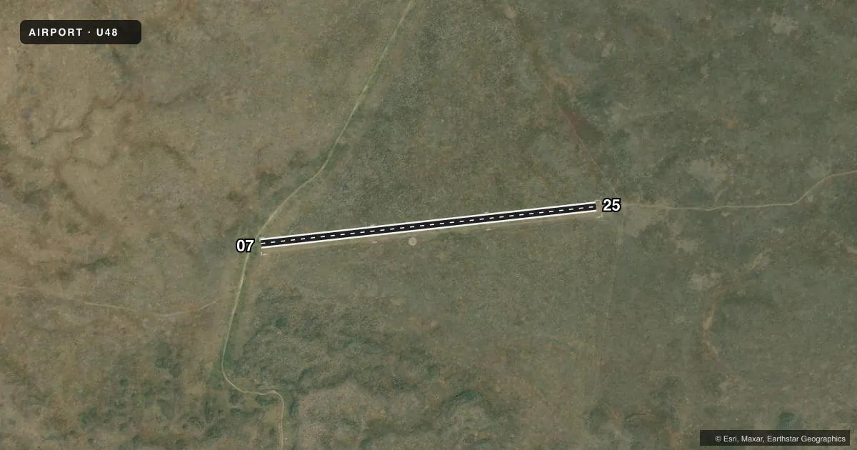
Runways & pattern
Full pagePattern entry · RWY 25
LEFT TRAFFICRunway end performance
| End | TORA | TODA | ASDA | LDA | VGSI | Approach lights | Obstruction |
|---|---|---|---|---|---|---|---|
| 07 | — | — | — | — | — | — | 14', road, 0' from thr, 80' R of cntrln, slope 0 |
| 25 | — | — | — | — | — | — | 5', fence, 175' from thr, 0' R of cntrln, slope 35 |
Declared distances in feet. TORA = takeoff run available, TODA = takeoff distance, ASDA = accelerate-stop, LDA = landing distance.
Airport sketch
Runways drawn to scale from FAA survey coordinates, rendered over satellite imagery. Not for navigation.
Approaches & charts
Services on the field
Fuel grades, oxygen, maintenance, ramp storage and lighting — as declared to the FAA by the airport operator.
Fuel & services
- Fuel
- Not available
- Oxygen (bottled)
- Not available
- Oxygen (bulk)
- Not available
- Airframe repair
- Not available
- Power plant repair
- Not available
Ramp & ground
- Transient storage
- Tie-down
- Landing fee
- No fee published
- Customs
- Not available
- Wind indicator
- Yes
- Segmented circle
- Yes
Fuel & FBOs
Cheapest 100LL and Jet A on the field and nearby. Always confirm with the FBO before taxi.
Airport notes
Surface conditions, obstructions, local procedures, lighting outages and other notes published with each FAA cycle.
General notes
- NO WINTER MAINTENANCE.
- RY 07/25 SFC MAY BE POOR DUE TO DAMAGE BY LIVESTOCK; GROUND VEHICLES AND RODENTS.
- FOR CD CTC SALT LAKE ARTCC AT 801-320-2568.
Approach & departure obstructions
- 0707/25 EDGES & THLDS MKD WITH WHITE ROCK.
- 0714' RD AT 50' ON CNTRLN.
Other notes
- ESTABD PRIOR TO 1959.
VFR map & nearby airports
VFR sectional. Tap any ICAO chip to open that airport.
Key facts · U48
Answer card- ICAO
- U48
- Name
- COXS WELL
- Location
- ATOMIC CITY, IDAHO
- Elevation
- 5,048 ft MSL
- Traffic pattern altitude
- 6,048 ft MSL (1,000 AGL)
- Control tower
- Non-towered (use CTAF)
- Total runways
- 1
- Longest runway
- 07/25 · 2,700 ft
- Published ILS approaches
- 0
- Published frequencies
- 1
- Magnetic variation
- 16°
- Current flight rules
- MVFR
- Current wind
- 230° at 6 kt
- Favored runway now
- RWY 25
COXS WELL (U48) sits near Atomic City, Idaho. The field elevation is 5,048 ft MSL. It has one runway. Runway 07/25 is 2,700 ft long and turf. The airport is not towered. CTAF is 122.9. No ILS approaches are published here.
The pattern altitude is not published. Use 1,000 ft AGL as the standard light-piston pattern unless the current FAA Chart Supplement says otherwise. The runway headings are magnetic 83° and 263°. Published remarks say the runway edges and thresholds are marked with white rock. They also note the surface may be poor because of damage from livestock, ground vehicles and rodents. Runway 07 has a 14-foot road about 50 feet on centerline. Treat the departure end with care.
This is a high-elevation turf strip. Expect density altitude to matter, especially on warm days. No winter maintenance is provided. There are no on-field FBOs listed. For clearance delivery, contact Salt Lake ARTCC at 801-320-2568. If you need current operational details, check the current FAA Chart Supplement or call the airport operator before you go.