METAR & TAF 1U0
1U0 does not publish a METAR.
Showing the nearest reporting station: KBYI (BURLEY MUNI) · 31.9 NM away. Conditions at 1U0 may differ.
METAR · KBYI
Observed 14:53Z
KBYI 271453Z AUTO 27006KT 2 1/2SM HZ OVC021 22/06 A3008 RMK AO2 SLP137 T02170061 53014
- Wind
- 270° @ 6 kt
- Visibility
- 0.5 SM
- Temp / Dew
- 22°C / 6°C
- Altimeter
- 30.08 inHg
- Clouds
- OVC
- Density alt
- 6,489 ft
- Ceiling
- 2,100 ft AGL
- Rules
- LIFR
Airport info & contacts
Manager on record, flight service, ARTCC, attendance schedule and pattern altitude — published by the FAA and refreshed every 28 days.
Location
- From city
- 15 NM NE
- VFR sectional
- SALT LAKE CITY
- ARTCC
- ZLC · SALT LAKE CITY
- NOTAM facility
- BOI (NOTAM-D)
Airport manager
- Name
- IDAHO DIV OF AERONAUTICS
- Phone
- 208-334-8775
- Address
- P O BOX 7129, BOISE ID 83707-1129
Flight service · Hours
- FSS BOI
- BOISE1-800-WX-BRIEF
- Attendance
- Unattended
Frequencies
Tap any row to copy the frequency to your clipboard.
Runways & pattern
Full pagePattern entry · RWY 24
LEFT TRAFFICRunway end performance
| End | TORA | TODA | ASDA | LDA | VGSI | Approach lights | Obstruction |
|---|---|---|---|---|---|---|---|
| 06 | — | — | — | — | — | — | 15', road, 400' from thr, 0' R of cntrln, slope 26 |
Declared distances in feet. TORA = takeoff run available, TODA = takeoff distance, ASDA = accelerate-stop, LDA = landing distance.
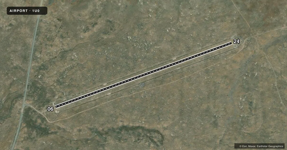
Airport sketch
Runways drawn to scale from FAA survey coordinates, rendered over satellite imagery. Not for navigation.
Approaches & charts
Services on the field
Fuel grades, oxygen, maintenance, ramp storage and lighting — as declared to the FAA by the airport operator.
Fuel & services
- Fuel
- Not available
- Oxygen (bottled)
- Not available
- Oxygen (bulk)
- Not available
- Airframe repair
- Not available
- Power plant repair
- Not available
Ramp & ground
- Transient storage
- Not published
- Landing fee
- No fee published
- Customs
- Not available
- Wind indicator
- Yes
- Segmented circle
- Yes
Fuel & FBOs
Cheapest 100LL and Jet A on the field and nearby. Always confirm with the FBO before taxi.
Airport notes
Surface conditions, obstructions, local procedures, lighting outages and other notes published with each FAA cycle.
General notes
- NO WINTER MAINTENANCE.
- NO LINE OF SIGHT BTN RWY ENDS.
- RY 06/24 SUBJECT TO ONGOING DAMAGE BY LIVESTOCK; GROUND VEHICLES & RODENTS.
- FOR CD CTC SALT LAKE ARTCC AT 801-320-2568.
Approach & departure obstructions
- 0624 EDGES & THLDS MKD WITH WHITE ROCK BOUNDARY MKRS (BMS).
Other notes
- ESTABD PRIOR TO 1959.
VFR map & nearby airports
VFR sectional. Tap any ICAO chip to open that airport.
Key facts · 1U0
Answer card- ICAO
- 1U0
- Name
- BEAR TRAP
- Location
- MINIDOKA, IDAHO
- Elevation
- 4,716 ft MSL
- Traffic pattern altitude
- 5,716 ft MSL (1,000 AGL)
- Control tower
- Non-towered (use CTAF)
- Total runways
- 1
- Longest runway
- 06/24 · 2,250 ft
- Published ILS approaches
- 0
- Published frequencies
- 1
- Magnetic variation
- 16°
- Current flight rules
- LIFR
- Current wind
- 270° at 6 kt
- Favored runway now
- RWY 24
Bear Trap Airport sits near Minidoka, Idaho. Field elevation is 4,716 ft MSL. The airport has one runway, 06/24, which is 2,250 ft long and surfaced turf-dirt. The runway headings are 70° and 250° magnetic. No control tower is on site. CTAF is 122.9.
No ILS approaches are published here. Pattern altitude is not published, so use the standard 1,000 ft AGL unless the current Chart Supplement says otherwise. At this elevation, density altitude can be a real factor on warm days. Plan performance with that in mind.
There are no on-field FBOs listed. Check with the airport operator or call the field directly before arrival if you need local services. Published remarks say runway 24 edges and thresholds are marked with white rock boundary markers. They also note no winter maintenance. They note no line of sight between runway ends. Ongoing damage risk from livestock, ground vehicles and rodents is also published. For clearance delivery, contact Salt Lake ARTCC at 801-320-2568. This is a small, non-towered field with a rough-surface runway, so a careful preflight and a good look at the surface before landing make sense.