METAR & TAF KBYI
Current METAR
Observed 16:15Z
KBYI 271615Z AUTO 26006KT 1 3/4SM HZ BKN021 21/07 A3009 RMK AO2 T02110067
- Wind
- 260° @ 6 kt
- Visibility
- 0.75 SM
- Temp / Dew
- 21°C / 7°C
- Altimeter
- 30.09 inHg
- Clouds
- BKN
- Density alt
- 5,660 ft
- Ceiling
- 2,100 ft AGL
- Rules
- LIFR
Airport info & contacts
Manager on record, flight service, ARTCC, attendance schedule and pattern altitude — published by the FAA and refreshed every 28 days.
Location
- From city
- 1 NM NE
- VFR sectional
- SALT LAKE CITY
- ARTCC
- ZLC · SALT LAKE CITY
- NOTAM facility
- BYI (NOTAM-D)
Airport manager
- Name
- KEVIN GEBHART
- Phone
- 208-678-0372
- Address
- P.O. BOX 157, BURLEY ID 83318
Flight service · Hours
- FSS BOI
- BOISE1-800-WX-BRIEF
- Attendance
- MAY-OCT · 0800-1700
- NOV-APR · MON-FRI · 0800-1700
- NOV-APR · WKENDS · ON CALL ONLY 208-678-7118
Frequencies
Tap any row to copy the frequency to your clipboard.
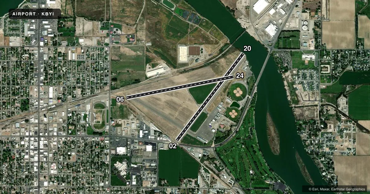
Runways & pattern
Full pagePattern entry · RWY 24
LEFT TRAFFIC| Runway | Heading (°M) | Length | Surface | Traffic |
|---|---|---|---|---|
| 02/20 | 22° / 202° | 4,092 ft | ASPH | Standard L |
| 06/24Favored | 64° / 244° | 4,072 ft | ASPH | Standard L |
Runway end performance
| End | TORA | TODA | ASDA | LDA | VGSI | Approach lights | Obstruction |
|---|---|---|---|---|---|---|---|
| 02 | — | — | — | — | VASI 4-box left(3.5°) | — | 20', road, 200' from thr, 0' R of cntrln, slope 0 |
| 20 | — | — | — | — | — | — | 100', stack, 2100' from thr, 40' R of cntrln, slope 19 |
| 06 | — | — | — | — | — | — | 27', rr, 200' from thr, 35' R of cntrln, slope 0 |
| 24 | — | — | — | — | VASI 2-box right(3°) | — | 32', tree, 735' from thr, 80' R of cntrln, slope 16 |
Declared distances in feet. TORA = takeoff run available, TODA = takeoff distance, ASDA = accelerate-stop, LDA = landing distance.
Airport sketch
Runways drawn to scale from FAA survey coordinates, rendered over satellite imagery. Not for navigation.
Approaches & charts
Services on the field
Fuel grades, oxygen, maintenance, ramp storage and lighting — as declared to the FAA by the airport operator.
Fuel & services
- Fuel
- 100LLA
- Oxygen (bottled)
- Low pressure
- Oxygen (bulk)
- Not available
- Airframe repair
- Major
- Power plant repair
- Major
- Other services
- AGRI,INSTR,SALES,SURV
Ramp & ground
- Transient storage
- Tie-down
- Landing fee
- No fee published
- Customs
- Not available
- Lighting schedule
- SEE RMK
- Beacon schedule
- SS-SR
- Beacon
- White / Green (civil land)(WG)
- Wind indicator
- Lighted
- Segmented circle
- No
Fuel & FBOs
Cheapest 100LL and Jet A on the field and nearby. Always confirm with the FBO before taxi.
Airport notes
Surface conditions, obstructions, local procedures, lighting outages and other notes published with each FAA cycle.
General notes
- BIRDS INVOF ALL RWYS; ESPECIALLY AER 20 & AER 24.
- RWY 02 & 06; NMRS CLOSE IN OBSTNS. 23 FT HIGH RAIL ROAD BOX CARS MAY BE PRKD ON TRKS OFF END OF RWY 02 & 06.
- MKD HELIPAD ON RAMP IN FRONT OF LIFE FLT BLDG.
- AGRICULTURAL ACTIVITY ON AND INVOF ALL RYS APR-OCT.
- FOR CD CTC TWIN FALLS APCH AT 208-734-7160, WHEN APCH CLSD CTC SALT LAKE ARTCC AT 801-320-2568.
- FOR FUEL SALES CTC FBO. NR ON THE FBO DOOR.
- RWY 2-20: RWY END 20: NMRS 80-120 FT STEAM STACKS LCTD 2800 FT NORTH OF ARPRT/SNAKE RIVER AT GEM PROCESSING PLANT; EXER EXTREME CTN ON ARR, SPCLY IN POOR VIS CONDS - SLP 18:1.
Lighting notes
- ACTVT REIL RWY 20; MIRL RWY 02/20 & 06/24 - CTAF (3 CLICKS TO TURN ON). VASI RWY 02 & 24 OPR CONSLY.
Approach & departure obstructions
- 027 FT FENCE 630 FT FM THLD ON CNTRLN; 27 FT RLRD 680 FT FM THLD ON CNTRLN; 15 FT RLRD SGL 660 FT FM THLD AND 140 FT R.
- 0623 FT RAIL ROAD 175 FT ON CNTRLN; +8 FT FENCE 0 FT FM THR 80 FT R.
- 0227 FT' RLRD 680 FT FM DSPLCD THR 17:1.
- 0623 FT RLRD 935 FT ON CNTRLN FM DSPLCD THR 31:1.
- 20RWY 20 120 FT STEAM STACKS 2800 FT NORTH RWY 20, SLP 31:1 TO DSPLCD THLD.
Other notes
- ESTABD PRIOR TO 15 MAY 1959.
- SURVAERIAL PHOTOGRAPHY
VFR map & nearby airports
VFR sectional. Tap any ICAO chip to open that airport.
Key facts · KBYI
Answer card- ICAO
- KBYI
- Name
- BURLEY MUNI
- Location
- BURLEY, IDAHO
- Elevation
- 4,153.5 ft MSL
- Traffic pattern altitude
- 5,153.5 ft MSL (1,000 AGL)
- Control tower
- Non-towered (use CTAF)
- Total runways
- 2
- Longest runway
- 02/20 · 4,092 ft
- Published ILS approaches
- 0
- Published frequencies
- 3
- Magnetic variation
- 15°
- Current flight rules
- LIFR
- Current wind
- 260° at 6 kt
- Favored runway now
- RWY 24
Burley Muni sits in Burley, Idaho at 4,153.5 ft MSL. It has two asphalt runways. The longest is 4,092 ft. This is a non-towered field, so expect self-announced traffic on CTAF 122.9 and coordinate with Twin Falls Approach for IFR services on the published frequencies. No ILS approaches are published here.
The pattern altitude is not published. For light piston operations, use the standard 1,000 ft AGL pattern unless the current Chart Supplement or local procedures say otherwise. The field is in a high-elevation part of Idaho, so performance planning matters on warm days. The airport also has published obstruction notes that deserve attention. Runway 20 has steam stacks north of the field. Runways 02 and 06 have close-in obstructions near the departure ends. Birds are reported in the area too. Agricultural activity also occurs on and near the runways from April through October.
The on-field FBO is The Flight Line. It carries 100LL and Jet A. If you need fuel or ramp details, call them directly at (208) 678-7118. A marked helipad is on the ramp in front of the Life Flight building. If you are planning a first arrival, brief the runway-specific obstruction notes before you go. The published remarks make it clear that Runway 20 and the 02 and 06 ends need extra caution, especially in low visibility.