METAR & TAF KTWF
Current METAR
Observed 13:16Z
KTWF 271316Z 24008KT 4SM HZ SCT026 22/01 A3007 RMK AO2 T02170011
- Wind
- 240° @ 8 kt
- Visibility
- 4 SM
- Temp / Dew
- 22°C / 1°C
- Altimeter
- 30.07 inHg
- Clouds
- SCT
- Density alt
- 5,804 ft
- Ceiling
- Unlimited
- Rules
- MVFR
Airport info & contacts
Manager on record, flight service, ARTCC, attendance schedule and pattern altitude — published by the FAA and refreshed every 28 days.
Location
- From city
- 4 NM S
- VFR sectional
- SALT LAKE CITY
- ARTCC
- ZLC · SALT LAKE CITY
- NOTAM facility
- TWF (NOTAM-D)
Airport manager
- Name
- MATT BARNES
- Phone
- 208-733-5215
- Address
- P.O. BOX 1907, TWIN FALLS ID 83303
Flight service · Hours
- FSS BOI
- BOISE1-800-WX-BRIEF
- Attendance
- 0630-2000
Frequencies
Tap any row to copy the frequency to your clipboard.
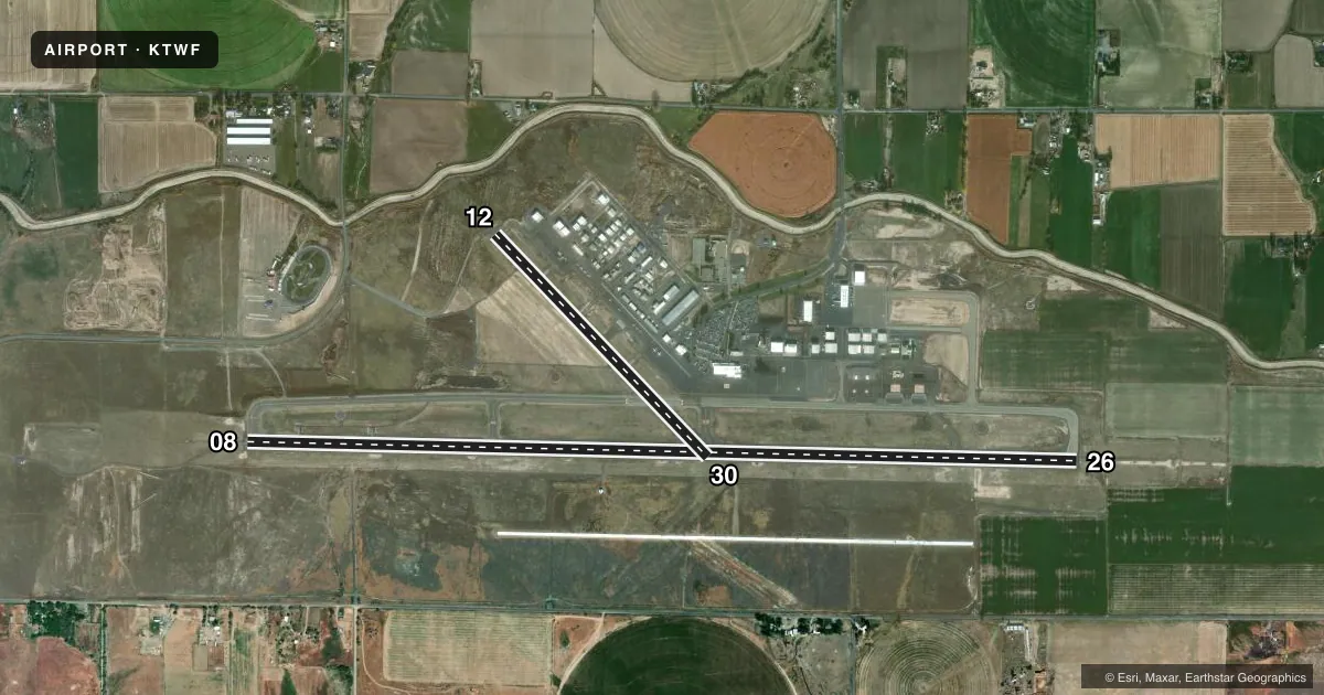
Runways & pattern
Full pagePattern entry · RWY 26
LEFT TRAFFIC| Runway | Heading (°M) | Length | Surface | Traffic |
|---|---|---|---|---|
| 08/26Favored | 78° / 258° | 8,704 ft | ASPH | Standard L |
| 12/30 | 123° / 303° | 3,224 ft | ASPH | Standard L |
Runway end performance
| End | TORA | TODA | ASDA | LDA | VGSI | Approach lights | Obstruction |
|---|---|---|---|---|---|---|---|
| 08 | — | — | — | — | VASI 4-box left(3°) | — | — |
| 26 | — | — | — | — | PAPI 4-box left(3°) | MALSR | — |
| 12 | — | — | — | — | — | — | 75', trees, 2000' from thr, slope 23 |
Declared distances in feet. TORA = takeoff run available, TODA = takeoff distance, ASDA = accelerate-stop, LDA = landing distance.
Airport sketch
Runways drawn to scale from FAA survey coordinates, rendered over satellite imagery. Not for navigation.
Approaches & charts
ILS · 1
Services on the field
Fuel grades, oxygen, maintenance, ramp storage and lighting — as declared to the FAA by the airport operator.
Fuel & services
- Fuel
- 100LLA1+
- Oxygen (bottled)
- High pressure
- Oxygen (bulk)
- High pressure
- Airframe repair
- Major
- Power plant repair
- Major
- Other services
- AFRT,AGRI,CARGO,CHTR,INSTR
Ramp & ground
- Transient storage
- Tie-down
- Hangar
- Landing fee
- Yes
- Customs
- Not available
- Lighting schedule
- SEE RMK
- Beacon schedule
- SS-SR
- Beacon
- White / Green (civil land)(WG)
- Wind indicator
- Lighted
- Segmented circle
- Yes
Fuel & FBOs
Cheapest 100LL and Jet A on the field and nearby. Always confirm with the FBO before taxi.
Airport notes
Surface conditions, obstructions, local procedures, lighting outages and other notes published with each FAA cycle.
General notes
- TWY G, H, J & K NON ACR MOV AREA.
- LN OF SIGHT BTN RWY 26 APCH END & RWY 12 APCH END NA.
- FOR CD IF UNA TO CTC ON FSS FREQ, CTC SALT LAKE ARTCC AT 801-320-2568.
Lighting notes
- WHEN ATCT CLSD ACTVT MALSR RWY 26, REIL RWY 08, HIRL RWY 08/26 - CTAF. PAPI RWY 26 OPR CONSLY.
Fuel notes
- 100LLSVC FEE 2000-0630; INFO 208-733-5920 OR 539-4034.
Runway surface & condition
- 08/26PCR VALUE: 1020/F/B/X/T
- 12/30PCR VALUE: 157/F/B/X/T
- 12/30NON ACR MOV AREA.
Other notes
- PPR UNSKED ACR OPS GTR THAN 30 PAX SEATS - AMGR.
- LNDG FEE FOR FAR PART 121, 135 OPR & GA PART 91 GTR THAN 12500 LB MGLW.
VFR map & nearby airports
VFR sectional. Tap any ICAO chip to open that airport.
Key facts · KTWF
Answer card- ICAO
- KTWF
- Name
- JOSLIN FLD/MAGIC VALLEY RGNL
- Location
- TWIN FALLS, IDAHO
- Elevation
- 4,153.4 ft MSL
- Traffic pattern altitude
- 5,153.4 ft MSL (1,000 AGL)
- Control tower
- Towered · 0600-2100
- Total runways
- 2
- Longest runway
- 08/26 · 8,704 ft
- Published ILS approaches
- 1
- Published frequencies
- 8
- Magnetic variation
- 13°
- Current flight rules
- MVFR
- Current wind
- 240° at 8 kt
- Favored runway now
- RWY 26
KTWF is in Twin Falls, Idaho. The field elevation is 4,153.4 ft MSL, so density altitude can matter here on warm days. The airport has two asphalt runways. The longest is 08/26 at 8,704 ft. Runway 12/30 is 3,224 ft.
The tower is open from 0600 to 2100. Runway 26 has the published ILS. Pattern altitude is not published in the facts, so use the standard 1,000 ft AGL for light piston traffic unless the current FAA Chart Supplement says otherwise. That puts the pattern at about 5,153 ft MSL based on the listed field elevation.
Jackson Jet Center is on the field. It carries 100LL, Jet A and Jet A Prist. The remarks also note that runway 26 and runway 12 do not have line of sight to each other. Taxiways G, H, J and K are non-aviation controlled movement areas. Runway 12/30 is also listed as a non-aviation controlled movement area.
This is a towered airport with published approach control and departure frequencies. If you are arriving at night or outside tower hours, note the lighting procedure for runway 26 and the runway 08 lights on CTAF. Check the current FAA Chart Supplement for any noise or operating restrictions before you go.