METAR & TAF KJER
Current METAR
Observed 03:53Z
KJER 270353Z AUTO 27006KT 4SM HZ CLR 27/03 A2999 RMK AO2 SLP109 T02670033
- Wind
- 270° @ 6 kt
- Visibility
- 4 SM
- Temp / Dew
- 27°C / 3°C
- Altimeter
- 29.99 inHg
- Clouds
- CLR
- Density alt
- 6,379 ft
- Ceiling
- Unlimited
- Rules
- MVFR
Airport info & contacts
Manager on record, flight service, ARTCC, attendance schedule and pattern altitude — published by the FAA and refreshed every 28 days.
Location
- From city
- 3 NM E
- VFR sectional
- SALT LAKE CITY
- ARTCC
- ZLC · SALT LAKE CITY
- NOTAM facility
- JER (NOTAM-D)
Airport manager
- Name
- MARTIN LUHR
- Phone
- 208-420-1158
- Address
- 472A HWY 25, JEROME ID 83338
Flight service · Hours
- FSS BOI
- BOISE1-800-WX-BRIEF
- Attendance
- 0800-1700
Frequencies
Tap any row to copy the frequency to your clipboard.
Runways & pattern
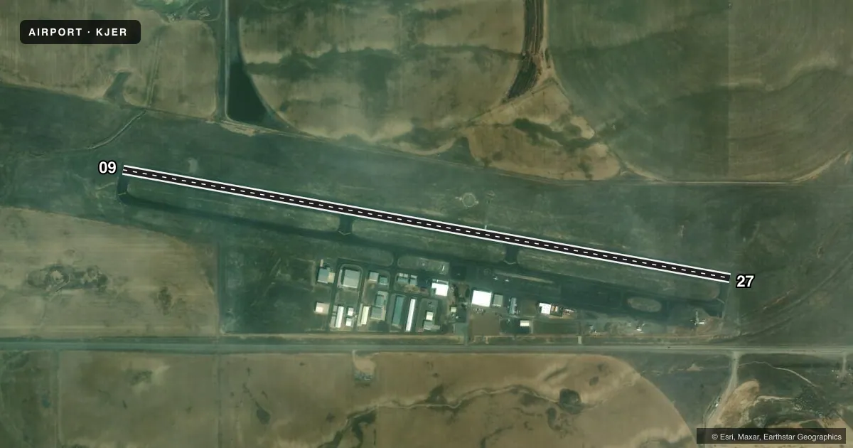
Full pagePattern entry · RWY 27
LEFT TRAFFICRunway end performance
| End | TORA | TODA | ASDA | LDA | VGSI | Approach lights | Obstruction |
|---|---|---|---|---|---|---|---|
| 09 | — | — | — | — | PAPI 4-box left(3°) | — | — |
| 27 | — | — | — | — | — | — | 8', fence, 400' from thr, 150' R of cntrln, slope 25 |
Declared distances in feet. TORA = takeoff run available, TODA = takeoff distance, ASDA = accelerate-stop, LDA = landing distance.
Airport sketch
Runways drawn to scale from FAA survey coordinates, rendered over satellite imagery. Not for navigation.
Approaches & charts
Services on the field
Fuel grades, oxygen, maintenance, ramp storage and lighting — as declared to the FAA by the airport operator.
Fuel & services
- Fuel
- 100LLAA+
- Airframe repair
- Major
- Power plant repair
- Major
- Other services
- AGRI,INSTR,PAJA
Ramp & ground
- Transient storage
- Tie-down
- Hangar
- Buoy
- Landing fee
- No fee published
- Customs
- Not available
- Lighting schedule
- SEE RMK
- Beacon schedule
- SS-SR
- Beacon
- White / Green (civil land)(WG)
- Wind indicator
- Lighted
- Segmented circle
- Yes
Fuel & FBOs
Cheapest 100LL and Jet A on the field and nearby. Always confirm with the FBO before taxi.
Airport notes
Surface conditions, obstructions, local procedures, lighting outages and other notes published with each FAA cycle.
General notes
- PARL TWY MKD WITH REFLECTORS.
- 700 FT MULT TWRS 1.3 NM ENE 2500 FT R OF RWY 27 APCH.
- FOR CD CTC TWIN FALLS APCH AT 208-734-7160, WHEN APCH CLSD CTC SALT LAKE ARTCC AT 801-320-2568.
Lighting notes
- ACTVT MIRL RWY 09/27 - CTAF 5 CLICKS.
Other notes
- ESTABD PRIOR TO 1959.
VFR map & nearby airports
VFR sectional. Tap any ICAO chip to open that airport.
Key facts · KJER
Answer card- ICAO
- KJER
- Name
- JEROME COUNTY
- Location
- JEROME, IDAHO
- Elevation
- 4,053.1 ft MSL
- Traffic pattern altitude
- 5,053.1 ft MSL (1,000 AGL)
- Control tower
- Non-towered (use CTAF)
- Total runways
- 1
- Longest runway
- 09/27 · 5,002 ft
- Published ILS approaches
- 0
- Published frequencies
- 4
- Magnetic variation
- 14°
- Current flight rules
- MVFR
- Current wind
- 270° at 6 kt
- Favored runway now
- RWY 27
Jerome County Airport sits in Jerome, Idaho at 4,053.1 ft MSL. It has one runway, 09/27, which is 5,002 ft long and paved with asphalt. The field is non-towered. Pattern altitude is not published, so use standard traffic pattern planning at 1,000 ft AGL unless local procedures or the current Chart Supplement say otherwise.
No ILS approaches are published here. For IFR work, plan around the current approach setup and coordinate with Twin Falls Approach. Published remarks also note multiple 700 ft towers about 1.3 NM east-northeast of the field. They sit right of the runway 27 approach path. That is worth keeping in mind on arrival and departure, especially when flying the west end.
On the field, Precision Aviation carries 100LL, Jet A and Jet A Prist. Jerome County Airport also carries 100LL, Jet A and Jet A Prist. The runway lights on 09/27 are activated by clicking the CTAF five times. The parallel taxiway is marked with reflectors. This is a high-elevation airport, so performance planning matters. Check density altitude before you go, especially on warm days. For clearance delivery, contact Twin Falls Approach. If approach is closed, use Salt Lake ARTCC.