METAR & TAF 1U6
1U6 does not publish a METAR.
Showing the nearest reporting station: KBYI (BURLEY MUNI) · 19.1 NM away. Conditions at 1U6 may differ.
METAR · KBYI
Observed 13:36Z
KBYI 271336Z AUTO 20006KT 2 1/2SM HZ BKN026 OVC034 18/10 A3006 RMK AO2 T01830100
- Wind
- 200° @ 6 kt
- Visibility
- 0.5 SM
- Temp / Dew
- 18°C / 10°C
- Altimeter
- 30.06 inHg
- Clouds
- OVC
- Density alt
- 5,970 ft
- Ceiling
- 2,600 ft AGL
- Rules
- LIFR
Airport info & contacts
Manager on record, flight service, ARTCC, attendance schedule and pattern altitude — published by the FAA and refreshed every 28 days.
Location
- From city
- 0 NM S
- VFR sectional
- SALT LAKE CITY
- ARTCC
- ZLC · SALT LAKE CITY
- NOTAM facility
- BOI (NOTAM-D)
Airport manager
- Name
- JARED MITTON
- Phone
- 208-431-6090
- Address
- P O BOX 266, OAKLEY ID 83346
Flight service · Hours
- FSS BOI
- BOISE1-800-WX-BRIEF
- Attendance
- Unattended
Frequencies
Tap any row to copy the frequency to your clipboard.
Runways & pattern
Full pagePattern entry · RWY 17
LEFT TRAFFICRunway end performance
| End | TORA | TODA | ASDA | LDA | VGSI | Approach lights | Obstruction |
|---|---|---|---|---|---|---|---|
| 17 | — | — | — | — | — | — | 5', fence, 50' from thr, 0' R of cntrln, slope 10 |
| 35 | — | — | — | — | — | — | 4', fence, 0' from thr, 105' R of cntrln, slope 0 |
Declared distances in feet. TORA = takeoff run available, TODA = takeoff distance, ASDA = accelerate-stop, LDA = landing distance.
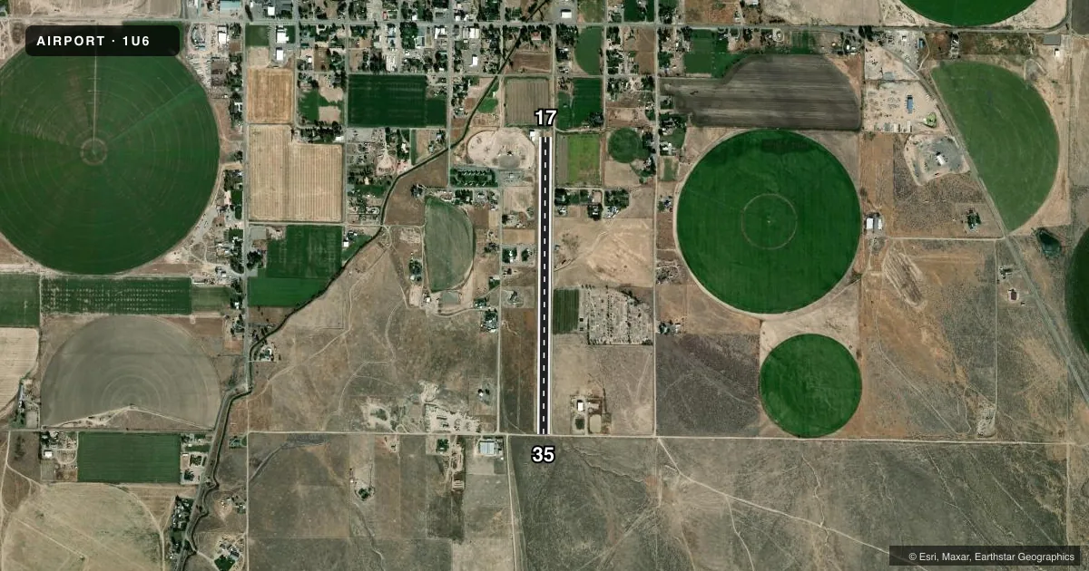
Airport sketch
Runways drawn to scale from FAA survey coordinates, rendered over satellite imagery. Not for navigation.
Approaches & charts
Services on the field
Fuel grades, oxygen, maintenance, ramp storage and lighting — as declared to the FAA by the airport operator.
Fuel & services
- Fuel
- Not available
- Oxygen (bottled)
- Not available
- Oxygen (bulk)
- Not available
- Airframe repair
- Not available
- Power plant repair
- Not available
Ramp & ground
- Transient storage
- Not published
- Landing fee
- No fee published
- Customs
- Not available
- Wind indicator
- Yes
- Segmented circle
- No
Fuel & FBOs
Cheapest 100LL and Jet A on the field and nearby. Always confirm with the FBO before taxi.
Airport notes
Surface conditions, obstructions, local procedures, lighting outages and other notes published with each FAA cycle.
General notes
- RWY SURFACE SOFT DURING EARLY SPRING.
- NO WINTER MAINTENANCE.
- RSG TRRN AT 3/4 MI S ON RWY CNTRLN.
- FOR CD CTC SALT LAKE ARTCC AT 801-320-2568.
- SVRL 75 FT TREES & 25 FT BLDGS, 1500 FT OUT & ON APCH TO RWY 17; RISING TRRN 1/2 MI OUT FM RWY 35.
Other notes
- ESTAB PRIOR TO 15 MAY 1959.
VFR map & nearby airports
VFR sectional. Tap any ICAO chip to open that airport.
Key facts · 1U6
Answer card- ICAO
- 1U6
- Name
- OAKLEY MUNI
- Location
- OAKLEY, IDAHO
- Elevation
- 4,664 ft MSL
- Traffic pattern altitude
- 5,664 ft MSL (1,000 AGL)
- Control tower
- Non-towered (use CTAF)
- Total runways
- 1
- Longest runway
- 17/35 · 3,795 ft
- Published ILS approaches
- 0
- Published frequencies
- 1
- Magnetic variation
- 16°
- Current flight rules
- LIFR
- Current wind
- 200° at 6 kt
- Favored runway now
- RWY 17
Oakley Muni sits in Oakley, Idaho. Field elevation is 4,664 ft MSL. The airport has one runway. Runway 17/35 is 3,795 ft long with a dirt-gravel surface. There is no control tower. CTAF is 122.9. No ILS approaches are published here.
Pattern altitude is not published. Use the standard 1,000 ft AGL pattern for light piston aircraft unless local conditions or published guidance say otherwise. That puts the pattern at about 5,664 ft MSL. The field has no on-field FBOs listed, so plan ahead for fuel and ground support. Published remarks call out rising terrain south of the field on the runway 17 centerline. They also note several 75 ft trees and 25 ft buildings about 1,500 ft out on the approach to runway 17. Rising terrain is also noted about half a mile out from runway 35. The runway surface can be soft in early spring. No winter maintenance is provided. For clearance delivery, contact Salt Lake ARTCC at 801-320-2568. A first-time pilot should treat this as a high-elevation, non-towered strip with limited approach support and terrain close in on both ends.