METAR & TAF 06U
06U does not publish a METAR.
Showing the nearest reporting station: KTWF (JOSLIN FLD/MAGIC VALLEY RGNL) · 31.3 NM away. Conditions at 06U may differ.
METAR · KTWF
Observed 13:16Z
KTWF 271316Z 24008KT 4SM HZ SCT026 22/01 A3007 RMK AO2 T02170011
- Wind
- 240° @ 8 kt
- Visibility
- 4 SM
- Temp / Dew
- 22°C / 1°C
- Altimeter
- 30.07 inHg
- Clouds
- SCT
- Density alt
- 7,131 ft
- Ceiling
- Unlimited
- Rules
- MVFR
Airport info & contacts
Manager on record, flight service, ARTCC, attendance schedule and pattern altitude — published by the FAA and refreshed every 28 days.
Location
- From city
- 0 NM E
- VFR sectional
- SALT LAKE CITY
- ARTCC
- ZLC · SALT LAKE CITY
- NOTAM facility
- RNO (NOTAM-D)
Airport manager
- Name
- SHAWN BURT
- Phone
- 775-755-2447
- Address
- AIRPORT MANAGER, PO BOX 337, JACKPOT NV 89825
Flight service · Hours
- FSS RNO
- RENO1-800-WX-BRIEF
- Attendance
- ON CALL
Frequencies
Tap any row to copy the frequency to your clipboard.
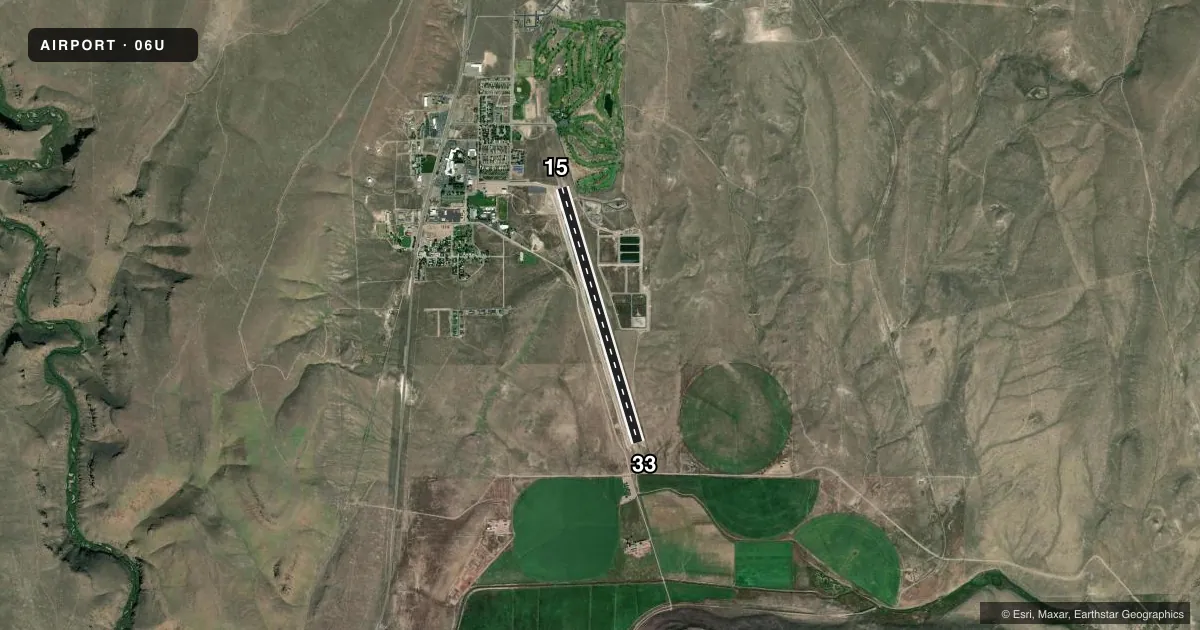
Runways & pattern
Full pagePattern entry · RWY 15
LEFT TRAFFICRunway end performance
| End | TORA | TODA | ASDA | LDA | VGSI | Approach lights | Obstruction |
|---|---|---|---|---|---|---|---|
| 15 | — | — | — | — | PAPI 2-box left(4°) | — | 54', trees, 1800' from thr, 100' R of cntrln, slope 29 |
| 33 | — | — | — | — | PAPI 2-box left(3.5°) | — | 200', hill, 5000' from thr, 0' R of cntrln, slope 24 |
Declared distances in feet. TORA = takeoff run available, TODA = takeoff distance, ASDA = accelerate-stop, LDA = landing distance.
Airport sketch
Runways drawn to scale from FAA survey coordinates, rendered over satellite imagery. Not for navigation.
Approaches & charts
Services on the field
Fuel grades, oxygen, maintenance, ramp storage and lighting — as declared to the FAA by the airport operator.
Fuel & services
- Fuel
- Not available
- Oxygen (bottled)
- Not available
- Oxygen (bulk)
- Not available
- Airframe repair
- Not available
- Power plant repair
- Not available
- Other services
- AMB
Ramp & ground
- Transient storage
- Tie-down
- Landing fee
- No fee published
- Customs
- Not available
- Lighting schedule
- SEE RMK
- Beacon schedule
- SEE RMK
- Beacon
- White / Green (civil land)(WG)
- Wind indicator
- Lighted
- Segmented circle
- Yes
Fuel & FBOs
Cheapest 100LL and Jet A on the field and nearby. Always confirm with the FBO before taxi.
Airport notes
Surface conditions, obstructions, local procedures, lighting outages and other notes published with each FAA cycle.
General notes
- TERRAIN OBSTNS LCTD S & W OF ARPT.
- BIRD HAZARD EAST OF ARPT AT PONDS.
- FUEL NOT AVBL.
- EMERGENCY CONTACT 208-731-2447
- IN NO WIND CONDS, RCMD DEP RWY 15, ARR RWY 33 FOR SLOPE.
Lighting notes
- SS-SR. BCN VIS LTD FM WEST.
- ACTVT REIL RWY 15 & 33; PAPI RWY 15 & 33; MIRL RWY 15/33 - CTAF.
VFR map & nearby airports
VFR sectional. Tap any ICAO chip to open that airport.
Key facts · 06U
Answer card- ICAO
- 06U
- Name
- JACKPOT/HAYDEN FLD
- Location
- JACKPOT, NEVADA
- Elevation
- 5,223.7 ft MSL
- Traffic pattern altitude
- 6,223.7 ft MSL (1,000 AGL)
- Control tower
- Non-towered (use CTAF)
- Total runways
- 1
- Longest runway
- 15/33 · 6,180 ft
- Published ILS approaches
- 0
- Published frequencies
- 2
- Magnetic variation
- 16°
- Current flight rules
- MVFR
- Current wind
- 240° at 8 kt
- Favored runway now
- RWY 15
JACKPOT/HAYDEN FLD sits at Jackpot, Nevada. The field elevation is 5,223.7 ft MSL. It has one runway, 15/33, which is 6,180 ft long on asphalt. There is no control tower. CTAF and UNICOM are both 122.8. No ILS approaches are published here.
The published pattern altitude is not listed, so use the standard 1,000 ft AGL for light piston operations unless the current FAA Chart Supplement says otherwise. That puts the pattern at about 6,223.7 ft MSL. The runway has medium intensity lighting, runway end identifier lights and PAPI on both ends. The beacon runs from sunset to sunrise. Beacon visibility is limited from the west.
The published remarks matter here. In calm wind, departure on runway 15 and arrival on runway 33 are recommended because of slope. Terrain obstructions are south and west of the airport. There is also a bird hazard east of the airport at the ponds. Fuel is not available on the field. If you need current operational details before arrival, call the airport operator or check the current FAA Chart Supplement. This is a high-elevation field. Performance planning deserves extra attention, especially on warm days.