METAR & TAF 3U0
3U0 does not publish a METAR.
Showing the nearest reporting station: KTWF (JOSLIN FLD/MAGIC VALLEY RGNL) · 46.7 NM away. Conditions at 3U0 may differ.
METAR · KTWF
Observed 21:53Z
KTWF 232153Z 10SM CLR 34/10 A3006 RMK AO2 SLP111 T03440100
- Wind
- Calm
- Visibility
- 10 SM
- Temp / Dew
- 34°C / 10°C
- Altimeter
- 30.06 inHg
- Clouds
- CLR
- Density alt
- 9,334 ft
- Ceiling
- Unlimited
- Rules
- VFR
Airport info & contacts
Manager on record, flight service, ARTCC, attendance schedule and pattern altitude — published by the FAA and refreshed every 28 days.
Location
- From city
- 9 NM W
- VFR sectional
- SALT LAKE CITY
- ARTCC
- ZLC · SALT LAKE CITY
- NOTAM facility
- BOI (NOTAM-D)
Airport manager
- Name
- DIV OF AERONAUTICS
- Phone
- 208-334-8775
- Address
- P O BOX 7129, BOISE ID 83707-1129
Flight service · Hours
- FSS BOI
- BOISE1-800-WX-BRIEF
- Attendance
- Unattended
Frequencies
Tap any row to copy the frequency to your clipboard.
Runways & pattern
Full pagePattern entry · RWY 01
LEFT TRAFFICRunway end performance
| End | TORA | TODA | ASDA | LDA | VGSI | Approach lights | Obstruction |
|---|---|---|---|---|---|---|---|
| 01 | — | — | — | — | — | — | 5', fence, 95' from thr, 0' R of cntrln, slope 19 |
| 19 | — | — | — | — | — | — | 5', fence, 140' from thr, 0' R of cntrln, slope 28 |
Declared distances in feet. TORA = takeoff run available, TODA = takeoff distance, ASDA = accelerate-stop, LDA = landing distance.
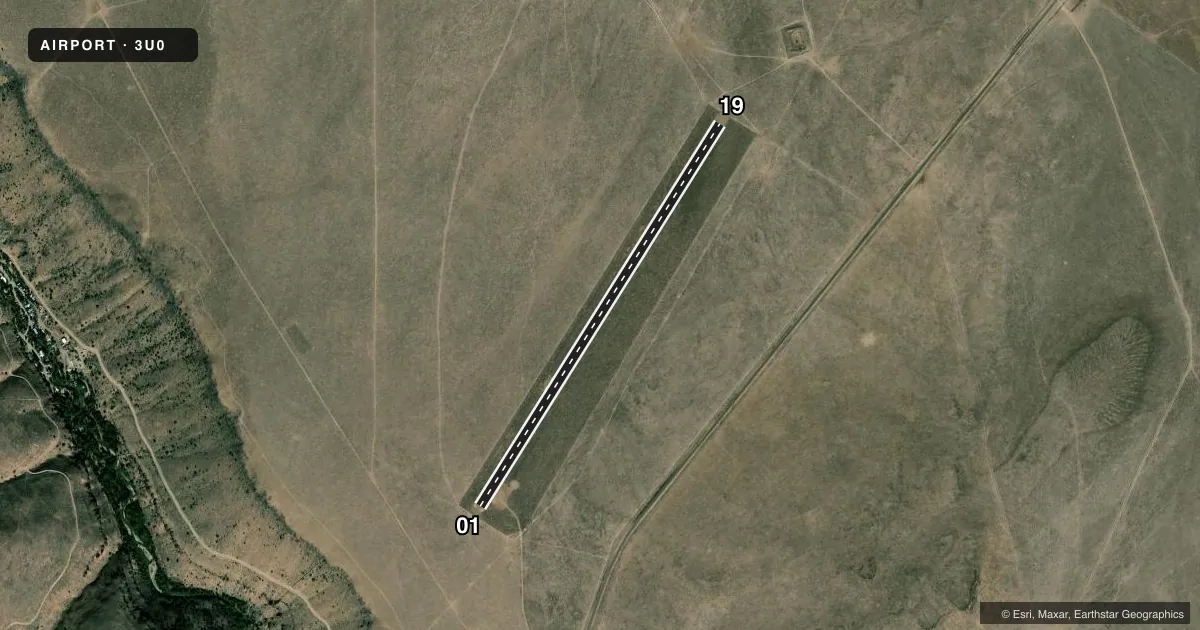
Airport sketch
Runways drawn to scale from FAA survey coordinates, rendered over satellite imagery. Not for navigation.
Approaches & charts
Services on the field
Fuel grades, oxygen, maintenance, ramp storage and lighting — as declared to the FAA by the airport operator.
Fuel & services
- Fuel
- Not available
- Oxygen (bottled)
- Not available
- Oxygen (bulk)
- Not available
- Airframe repair
- Not available
- Power plant repair
- Not available
Ramp & ground
- Transient storage
- Tie-down
- Landing fee
- No fee published
- Wind indicator
- Yes
- Segmented circle
- Yes
Fuel & FBOs
Cheapest 100LL and Jet A on the field and nearby. Always confirm with the FBO before taxi.
Airport notes
Surface conditions, obstructions, local procedures, lighting outages and other notes published with each FAA cycle.
General notes
- NO WINTER MAINTENANCE.
- YELLOW & BLACK FENCE MRKG PANELS ON APCHS TO RWY 01 & 19.
- NO LINE OF SIGHT BTN RWY ENDS.
- RCMD LND RY 19; DPT RY 01 WHEN WND CONDS PERMIT.
- NO TELEPHONE AVBL AT ARPT.
- RWY SOFT IN SPRING & WHEN WET, SPCLY FIRST 2000 FT OF RWY 19.
- FOR CD CTC SALT LAKE ARTCC AT 801-320-2568.
Approach & departure obstructions
- 0101/19 EDGES & THLDS MKD WITH WHITE ROCK.
Other notes
- ESTABD PRIOR TO 1959.
VFR map & nearby airports
VFR sectional. Tap any ICAO chip to open that airport.
Key facts · 3U0
Answer card- ICAO
- 3U0
- Name
- MURPHY HOT SPRINGS
- Location
- THREE CREEK, IDAHO
- Elevation
- 5,829 ft MSL
- Traffic pattern altitude
- 6,829 ft MSL (1,000 AGL)
- Control tower
- Non-towered (use CTAF)
- Total runways
- 1
- Longest runway
- 01/19 · 5,250 ft
- Published ILS approaches
- 0
- Published frequencies
- 1
- Magnetic variation
- 16°
- Current flight rules
- VFR
- Current wind
- Calm / unavailable
- Favored runway now
- –
Murphy Hot Springs Airport (3U0) sits near Three Creek, Idaho. The field elevation is 5,829 ft MSL. It has one runway. Runway 01/19 is 5,250 ft of turf. No tower is published here. CTAF is 122.9. No ILS approaches are published.
The pattern altitude is not published. Use the standard 1,000 ft AGL unless the current Chart Supplement says otherwise. That puts the light-piston pattern at 6,829 ft MSL. The airport remarks matter here. Runway 19 is the recommended landing runway. Depart runway 01 when wind conditions permit. The runway can be soft in spring and when wet, especially the first 2,000 ft of runway 19. There is no winter maintenance. There is also no telephone at the airport.
Runway ends are marked with white rock. Yellow and black fence panels mark the approaches to both ends. There is no line of sight between runway ends, so plan your traffic calls carefully. The field is high enough that density altitude can be a real factor in warm weather. No on-field FBOs are listed. Check the current Chart Supplement and call the airport operator or the FBO directly by phone before you go.