METAR & TAF 10U
Current METAR
Observed 03:15Z
K10U 270315Z AUTO 28006KT 10SM CLR 28/M06 A3010 RMK AO2
- Wind
- 280° @ 6 kt
- Visibility
- 10 SM
- Temp / Dew
- 28°C / -6°C
- Altimeter
- 30.10 inHg
- Clouds
- CLR
- Density alt
- 8,005 ft
- Ceiling
- Unlimited
- Rules
- VFR
Airport info & contacts
Manager on record, flight service, ARTCC, attendance schedule and pattern altitude — published by the FAA and refreshed every 28 days.
Location
- From city
- 4 NM W
- VFR sectional
- SALT LAKE CITY
- ARTCC
- ZLC · SALT LAKE CITY
- NOTAM facility
- RNO (NOTAM-D)
Airport manager
- Name
- CODY STEELE
- Phone
- 208-810-0879
- Address
- 1036 IDAHO STATE HIGHWAY 51, PO BOX 219, OWYHEE NV 89832
Flight service · Hours
- FSS RNO
- RENO1-800-WX-BRIEF
- Attendance
- Unattended
Frequencies
Tap any row to copy the frequency to your clipboard.
Runways & pattern
Full pagePattern entry · RWY 23
LEFT TRAFFICRunway end performance
| End | TORA | TODA | ASDA | LDA | VGSI | Approach lights | Obstruction |
|---|---|---|---|---|---|---|---|
| 05 | — | — | — | — | PAPI 2-box left(3°) | — | — |
| 23 | — | — | — | — | PAPI 2-box left(3°) | — | — |
Declared distances in feet. TORA = takeoff run available, TODA = takeoff distance, ASDA = accelerate-stop, LDA = landing distance.
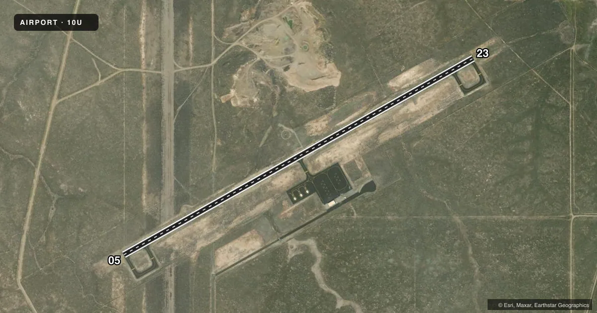
Airport sketch
Runways drawn to scale from FAA survey coordinates, rendered over satellite imagery. Not for navigation.
Approaches & charts
Services on the field
Fuel grades, oxygen, maintenance, ramp storage and lighting — as declared to the FAA by the airport operator.
Fuel & services
- Fuel
- Not available
- Oxygen (bottled)
- Not available
- Oxygen (bulk)
- Not available
- Airframe repair
- Not available
- Power plant repair
- Not available
- Other services
- AMB
Ramp & ground
- Transient storage
- Tie-down
- Landing fee
- No fee published
- Lighting schedule
- SEE RMK
- Beacon schedule
- SS-SR
- Beacon
- White / Green (civil land)(WG)
- Wind indicator
- Lighted
- Segmented circle
- Yes
Fuel & FBOs
Cheapest 100LL and Jet A on the field and nearby. Always confirm with the FBO before taxi.
Airport notes
Surface conditions, obstructions, local procedures, lighting outages and other notes published with each FAA cycle.
General notes
- BIRD ACT INVOF AIRPORT.
- TIE-DOWN CHAINS NOT PRVDD.
- FOR CD CTC SALT LAKE ARTCC AT 801-320-2568.
- 3 HEL PRKG PADS ADJ TO MAIN RAMP.
Lighting notes
- ACTVT REIL RWY 05 & 23; PAPI RWY 05 & 23; MIRL RWY 05/23 - CTAF.
Approach & departure obstructions
- 23PAPI UNUSBL BYD 3.25 NM DUE TO TRRN.
Other notes
- ESTABD PRIOR TO MAY 1959.
- MANAGEROTR CTCS: 208-759-3100 EXT 1255 OR EXT 1209, AND 208-409-4071.
VFR map & nearby airports
VFR sectional. Tap any ICAO chip to open that airport.
Key facts · 10U
Answer card- ICAO
- 10U
- Name
- OWYHEE
- Location
- OWYHEE, NEVADA
- Elevation
- 5,377.2 ft MSL
- Traffic pattern altitude
- 6,377.2 ft MSL (1,000 AGL)
- Control tower
- Non-towered (use CTAF)
- Total runways
- 1
- Longest runway
- 05/23 · 4,700 ft
- Published ILS approaches
- 0
- Published frequencies
- 1
- Magnetic variation
- 12°
- Current flight rules
- VFR
- Current wind
- 280° at 6 kt
- Favored runway now
- RWY 23
Owyhee Airport (10U) sits in Owyhee, Nevada. The field elevation is 5,377.2 ft MSL. It has one runway. Runway 05/23 is 4,700 ft asphalt, which is the longest runway on the field. There is no control tower. CTAF is 122.9.
No ILS approaches are published here. Pattern altitude is not published, so use the standard 1,000 ft AGL for light piston operations unless the current Chart Supplement says otherwise. The airport is in a high-elevation part of Nevada, so performance planning matters. Expect thinner air and longer takeoff rolls than you would see at lower fields.
Published remarks note runway end identifier lights on both ends of 05/23. PAPI is installed on both runway ends. The runway lights are medium intensity and are controlled on CTAF. Bird activity is reported in the area. Runway 23 has a PAPI limitation beyond 3.25 NM because of terrain. There are no on-field FBOs listed, so call the airport operator directly or contact the field on CTAF for current fuel and service availability. For clearance delivery, contact Salt Lake ARTCC. Tie-down chains are not provided.