METAR & TAF 26U
26U does not publish a METAR.
Showing the nearest reporting station: KREO (ROME STATE) · 34.8 NM away. Conditions at 26U may differ.
METAR · KREO
Observed 04:52Z
KREO 270452Z AUTO 05006KT 22/M03 A3003 RMK AO1 SLP122 T02221033
- Wind
- 050° @ 6 kt
- Visibility
- —
- Temp / Dew
- 22°C / -3°C
- Altimeter
- 30.03 inHg
- Clouds
- Clear
- Density alt
- 6,256 ft
- Ceiling
- Unlimited
- Rules
- VFR
Airport info & contacts
Manager on record, flight service, ARTCC, attendance schedule and pattern altitude — published by the FAA and refreshed every 28 days.
Location
- From city
- 0 NM W
- VFR sectional
- KLAMATH FALLS
- ARTCC
- ZLC · SALT LAKE CITY
- NOTAM facility
- MMV (NOTAM-D)
Airport manager
- Name
- STATE AIRPORTS MANAGER
- Phone
- 503-378-4880
- Address
- 3040 25TH ST SE, SALEM OR 97302-1125
Flight service · Hours
- FSS MMV
- MC MINNVILLE1-800-WX-BRIEF
- Attendance
- Unattended
Frequencies
Tap any row to copy the frequency to your clipboard.
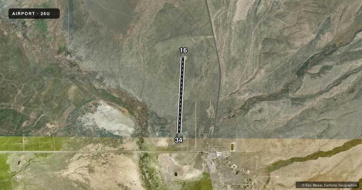
Runways & pattern
Full pagePattern entry · RWY 34
LEFT TRAFFICAirport sketch
Runways drawn to scale from FAA survey coordinates, rendered over satellite imagery. Not for navigation.
Approaches & charts
Services on the field
Fuel grades, oxygen, maintenance, ramp storage and lighting — as declared to the FAA by the airport operator.
Fuel & services
- Fuel
- Not available
- Airframe repair
- Not available
- Power plant repair
- Not available
Ramp & ground
- Transient storage
- Tie-down
- Landing fee
- No fee published
- Lighting schedule
- SEE RMK
- Beacon schedule
- SS-SR
- Beacon
- White / Green (civil land)(WG)
- Wind indicator
- Lighted
- Segmented circle
- Yes
Fuel & FBOs
Cheapest 100LL and Jet A on the field and nearby. Always confirm with the FBO before taxi.
Airport notes
Surface conditions, obstructions, local procedures, lighting outages and other notes published with each FAA cycle.
General notes
- RISING TERRAIN TO NORTH OF ARPT AT APPROXIMATELY 2% FOR 10000 FT.
- SURFACE CONDITIONS NOT REPORTED.
- FOR CD CTC SALT LAKE ARTCC AT 801-320-2568.
Lighting notes
- ACTVT MIRL RWY 16/34 - CTAF.
VFR map & nearby airports
VFR sectional. Tap any ICAO chip to open that airport.
Key facts · 26U
Answer card- ICAO
- 26U
- Name
- MC DERMITT STATE
- Location
- MC DERMITT, OREGON
- Elevation
- 4,478 ft MSL
- Traffic pattern altitude
- 5,478 ft MSL (1,000 AGL)
- Control tower
- Non-towered (use CTAF)
- Total runways
- 1
- Longest runway
- 16/34 · 5,900 ft
- Published ILS approaches
- 0
- Published frequencies
- 1
- Magnetic variation
- 17°
- Current flight rules
- VFR
- Current wind
- 050° at 6 kt
- Favored runway now
- RWY 34
Mc Dermitt State Airport sits in Mc Dermitt, Oregon. The field elevation is 4,478 ft MSL. It has one runway, 16/34, which is 5,900 ft long with an asphalt surface. There is no control tower. CTAF is 122.9. No ILS approaches are published here.
The pattern altitude is not published. Use the standard 1,000 ft AGL pattern unless the current Chart Supplement says otherwise. The published remarks say runway 16/34 has medium intensity lights that are activated by the CTAF. Surface conditions are not reported, so check the runway before you commit. Clearance delivery goes through Salt Lake ARTCC at 801-320-2568.
This is high-elevation country. Expect performance to change with density altitude, especially on warm days. The published remarks also call out rising terrain to the north for about 10,000 ft. That matters on departure and when planning pattern work. There are no on-field FBOs listed in the facts, so verify services with the airport operator or the FBO directly by phone before you go.