METAR & TAF 28U
28U does not publish a METAR.
Showing the nearest reporting station: KEUL (CALDWELL EXEC) · 33.5 NM away. Conditions at 28U may differ.
METAR · KEUL
Observed 04:56Z
KEUL 270456Z AUTO 00000KT 4SM HZ CLR 24/13 A2991 RMK AO2 SLP105 T02440128 $
- Wind
- 000° @ 0 kt
- Visibility
- 4 SM
- Temp / Dew
- 24°C / 13°C
- Altimeter
- 29.91 inHg
- Clouds
- CLR
- Density alt
- 4,416 ft
- Ceiling
- Unlimited
- Rules
- MVFR
Airport info & contacts
Manager on record, flight service, ARTCC, attendance schedule and pattern altitude — published by the FAA and refreshed every 28 days.
Location
- From city
- 25 NM SW
- VFR sectional
- KLAMATH FALLS
- ARTCC
- ZLC · SALT LAKE CITY
- NOTAM facility
- MMV (NOTAM-D)
Airport manager
- Name
- STATE AIRPORTS MANAGER
- Phone
- 503-378-4880
- Address
- 3040 25TH ST, SE, SALEM OR 97302-1125
Flight service · Hours
- FSS MMV
- MC MINNVILLE1-800-WX-BRIEF
- Attendance
- Unattended
Frequencies
Tap any row to copy the frequency to your clipboard.
Runways & pattern
Full pagePattern entry · RWY 13
LEFT TRAFFICRunway end performance
| End | TORA | TODA | ASDA | LDA | VGSI | Approach lights | Obstruction |
|---|---|---|---|---|---|---|---|
| 13 | — | — | — | — | — | — | 18', trees, 218' from thr, 89' R of cntrln, slope 12 |
Declared distances in feet. TORA = takeoff run available, TODA = takeoff distance, ASDA = accelerate-stop, LDA = landing distance.
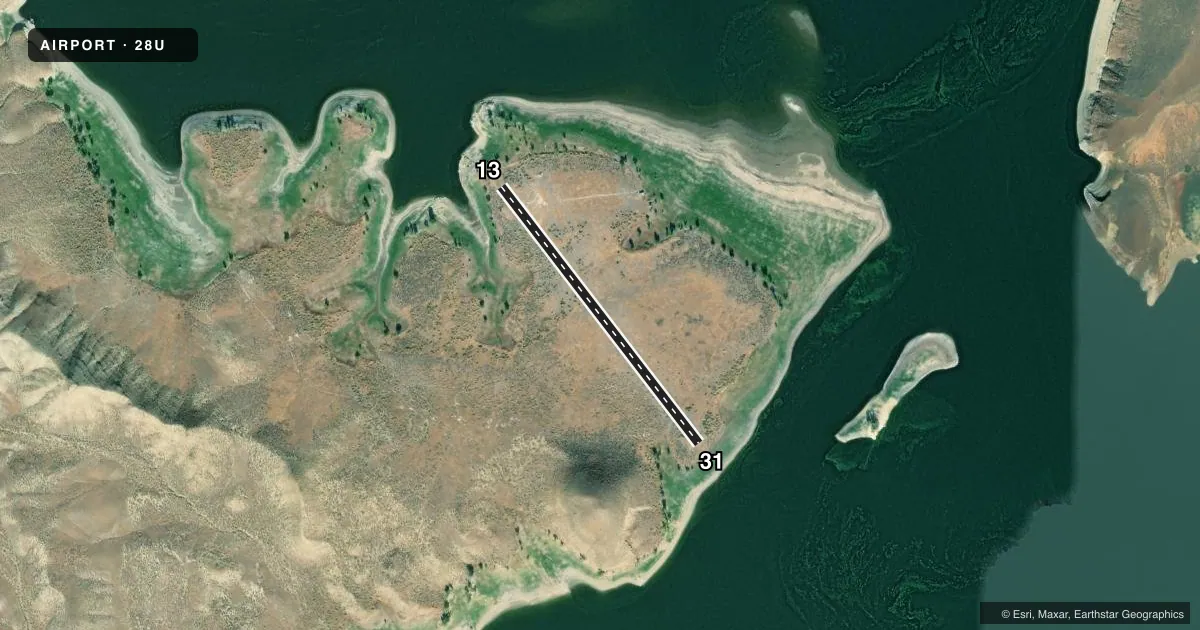
Airport sketch
Runways drawn to scale from FAA survey coordinates, rendered over satellite imagery. Not for navigation.
Approaches & charts
Services on the field
Fuel grades, oxygen, maintenance, ramp storage and lighting — as declared to the FAA by the airport operator.
Fuel & services
- Fuel
- Not available
- Oxygen (bottled)
- Not available
- Oxygen (bulk)
- Not available
- Airframe repair
- Not available
- Power plant repair
- Not available
Ramp & ground
- Transient storage
- Tie-down
- Landing fee
- No fee published
- Wind indicator
- Yes
- Segmented circle
- No
Fuel & FBOs
Cheapest 100LL and Jet A on the field and nearby. Always confirm with the FBO before taxi.
Airport notes
Surface conditions, obstructions, local procedures, lighting outages and other notes published with each FAA cycle.
General notes
- OWNER ADVISES CONTACT WITH STATE DEPT OF AVIATION 503-378-4880 PRIOR TO USE.
- REMOTE AIRPORT; NO GROUND ACCESS.
- AIRPORT IN CANYON; SURROUNDED BY HIGH TERRAIN.
- 4 FT BRUSH GROWTH WITHIN 20 FT OF RWY EDGE.
- FOR CD CTC SALT LAKE ARTCC AT 801-320-2568.
- SUR CONDS NOT RPRTD
- OPEN RANGE LIVESTOCK MAY BE PRESENT ON RWY.
Other notes
- ESTABD PRIOR TO 1959.
- 13/31IRREGULAR MAINTENANCE. RUNWAY SURFACE FREQUENTLY ROUGH AND RUTTED
VFR map & nearby airports
VFR sectional. Tap any ICAO chip to open that airport.
Key facts · 28U
Answer card- ICAO
- 28U
- Name
- OWYHEE RESERVOIR STATE
- Location
- OWYHEE, OREGON
- Elevation
- 2,680 ft MSL
- Traffic pattern altitude
- 3,680 ft MSL (1,000 AGL)
- Control tower
- Non-towered (use CTAF)
- Total runways
- 1
- Longest runway
- 13/31 · 1,840 ft
- Published ILS approaches
- 0
- Published frequencies
- 1
- Magnetic variation
- 17°
- Current flight rules
- MVFR
- Current wind
- 000° at 0 kt
- Favored runway now
- –
Owyhee Reservoir State Airport (28U) sits in Owyhee, Oregon at 2,680 ft MSL. It has one runway. Runway 13/31 is 1,840 ft long with dirt surface. The field is not towered. CTAF is 122.9. No ILS approaches are published.
Pattern altitude is not published. Use 1,000 ft AGL as the standard light piston pattern unless the current Chart Supplement says otherwise. That puts the pattern at 3,680 ft MSL.
This is a remote airport with no ground access. The owner advises calling the State Department of Aviation before use. The field is in a canyon. High terrain surrounds it. Surface conditions are not reported. The Chart Supplement also notes 4-foot brush growth within 20 feet of the runway edge. Runway 13/31 has irregular maintenance. The surface is frequently rough and rutted.
There are no on-field FBOs listed. Plan to self-brief carefully before you go. Check the current Chart Supplement for any published restrictions or operational changes. For clearance delivery, contact Salt Lake ARTCC at 801-320-2568. With a short dirt strip, canyon terrain and no reported surface condition, this is not a casual stop. A first-time pilot should treat it as a remote backcountry-style landing site. Verify the runway condition before committing.