METAR & TAF 1U3
1U3 does not publish a METAR.
Showing the nearest reporting station: KMAN (NAMPA MUNI) · 22.0 NM away. Conditions at 1U3 may differ.
METAR · KMAN
Observed 06:35Z
KMAN 270635Z AUTO 00000KT 5SM HZ BKN025 BKN035 OVC080 20/13 A2992 RMK A01
- Wind
- 000° @ 0 kt
- Visibility
- 5 SM
- Temp / Dew
- 20°C / 13°C
- Altimeter
- 29.92 inHg
- Clouds
- OVC
- Density alt
- 4,140 ft
- Ceiling
- 2,500 ft AGL
- Rules
- MVFR
Airport info & contacts
Manager on record, flight service, ARTCC, attendance schedule and pattern altitude — published by the FAA and refreshed every 28 days.
Location
- From city
- 0 NM E
- VFR sectional
- SALT LAKE CITY
- ARTCC
- ZLC · SALT LAKE CITY
- NOTAM facility
- BOI (NOTAM-D)
Airport manager
- Name
- JIM DESMOND
- Phone
- 208-249-0571
- Address
- 2773 N HAVEN, EAGLE ID 83616
Flight service · Hours
- FSS BOI
- BOISE1-800-WX-BRIEF
- Attendance
- Unattended
Frequencies
Tap any row to copy the frequency to your clipboard.
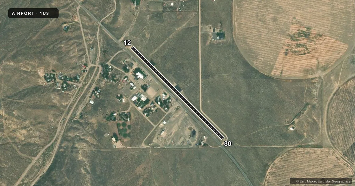
Runways & pattern
Full pagePattern entry · RWY 12
LEFT TRAFFICRunway end performance
| End | TORA | TODA | ASDA | LDA | VGSI | Approach lights | Obstruction |
|---|---|---|---|---|---|---|---|
| 12 | — | — | — | — | — | — | 17', road, 200' from thr, 85' R of cntrln, slope 0 |
| 30 | — | — | — | — | — | — | 17', road, 200' from thr, 90' R of cntrln, slope 0 |
Declared distances in feet. TORA = takeoff run available, TODA = takeoff distance, ASDA = accelerate-stop, LDA = landing distance.
Airport sketch
Runways drawn to scale from FAA survey coordinates, rendered over satellite imagery. Not for navigation.
Approaches & charts
Services on the field
Fuel grades, oxygen, maintenance, ramp storage and lighting — as declared to the FAA by the airport operator.
Fuel & services
- Fuel
- Not available
- Oxygen (bottled)
- Not available
- Oxygen (bulk)
- Not available
- Airframe repair
- Not available
- Power plant repair
- Not available
Ramp & ground
- Transient storage
- Tie-down
- Landing fee
- No fee published
- Wind indicator
- Yes
- Segmented circle
- No
Fuel & FBOs
Cheapest 100LL and Jet A on the field and nearby. Always confirm with the FBO before taxi.
Airport notes
Surface conditions, obstructions, local procedures, lighting outages and other notes published with each FAA cycle.
General notes
- NUMEROUS SIGNS TO +12' ON BOTH SIDES OF HIGHWAY ADJACENT TO RY.
- RWY 30 HAS 40 FT PLINE & RISING TRRN AT 1670 FT ON CNTRLN.
- FOR CD CTC BIG SKY APCH AT 208-364-5860/5861.
Runway surface & condition
- 12/30RCMD LAND RY 12 TKOF RY 30 WHEN WIND COND PERMITS.
Approach & departure obstructions
- 12+3 FT FENCE 20 FT FM RY END 60 FT L; +10 FT ROAD 0' FM RY END 100 FT R; +6 FT SIGN AT 20 FT 80 FT R.
- 30+17 FT RD 0 FT FM RY END 100 FT L; +10 FT ROAD AT 50 FT ON CNTRLN.
- 12RWY NRS FADED & DFCLT TO SEE FM THE AIR.
- 30RWY NRS FADED & DFCLT TO SEE FM THE AIR.
- 12RWY END 12 HAS A 10 FT PVT DIRT ROAD GOING WI THE PRI SFC AREA.
- 30RWY END 30 HAS 10 FT PVT DIRT ROAD GOING WI THE PRI SFC AREA.
Other notes
- EXISTED PRIOR TO 4/2/59.
- 2CTC SHERIFF'S OFC IN COURTHOUSE ACROSS HWY FM ARPT FOR ASSISTANCE
VFR map & nearby airports
VFR sectional. Tap any ICAO chip to open that airport.
Key facts · 1U3
Answer card- ICAO
- 1U3
- Name
- MURPHY
- Location
- MURPHY, IDAHO
- Elevation
- 2,855 ft MSL
- Traffic pattern altitude
- 3,855 ft MSL (1,000 AGL)
- Control tower
- Non-towered (use CTAF)
- Total runways
- 1
- Longest runway
- 12/30 · 2,500 ft
- Published ILS approaches
- 0
- Published frequencies
- 1
- Magnetic variation
- 17°
- Current flight rules
- MVFR
- Current wind
- 000° at 0 kt
- Favored runway now
- –
Murphy Airport sits in Murphy, Idaho. The field elevation is 2,855 ft MSL. It has one runway, 12/30. The longest runway is 2,500 ft of asphalt. There is no control tower. CTAF is 122.9. No ILS approaches are published.
The pattern altitude is not published in the facts. Use the standard 1,000 ft AGL for light piston traffic unless the current Chart Supplement says otherwise. For this field, that puts pattern altitude at about 3,855 ft MSL. The published remarks matter here. Runway 12 is the recommended landing runway when wind allows. Runway 30 is the recommended takeoff runway when wind allows. The runway environment has several close-in obstructions. There are roads near both ends. Runway 30 also has a power line and rising terrain on centerline. The runway numbers are faded and hard to pick out from the air. Clearance delivery is handled through Big Sky Approach by phone. For ground help, the sheriff’s office is across the highway from the airport. No on-field FBOs are listed. Verify fuel and services with the airport operator or the FBO directly by phone before you go.