METAR & TAF KMAN
Current METAR
Observed 15:15Z
KMAN 271515Z AUTO 30008KT 3SM HZ CLR 22/04 A3003 RMK A01
- Wind
- 300° @ 8 kt
- Visibility
- 3 SM
- Temp / Dew
- 22°C / 4°C
- Altimeter
- 30.03 inHg
- Clouds
- CLR
- Density alt
- 3,849 ft
- Ceiling
- Unlimited
- Rules
- MVFR
Airport info & contacts
Manager on record, flight service, ARTCC, attendance schedule and pattern altitude — published by the FAA and refreshed every 28 days.
Location
- From city
- 0 NM E
- VFR sectional
- SALT LAKE CITY
- ARTCC
- ZLC · SALT LAKE CITY
- NOTAM facility
- BOI (NOTAM-D)
Airport manager
- Name
- LYNSEY JOHNSON
- Phone
- 208-468-5823
- Address
- 116 MUNICIPAL DRIVE, NAMPA ID 83687
Flight service · Hours
- FSS BOI
- BOISE1-800-WX-BRIEF
- Attendance
- 0800-1700
Frequencies
Tap any row to copy the frequency to your clipboard.
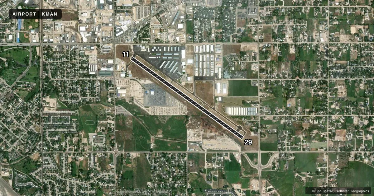
Runways & pattern
Full pagePattern entry · RWY 29
LEFT TRAFFICRunway end performance
| End | TORA | TODA | ASDA | LDA | VGSI | Approach lights | Obstruction |
|---|---|---|---|---|---|---|---|
| 11 | — | — | — | — | PAPI 2-box left(3°) | — | 15', road, 550' from thr, 0' R of cntrln, slope 23 |
| 29 | — | — | — | — | PAPI 2-box left(3.62°) | — | 60', trees, 1350' from thr, 125' R of cntrln, slope 19 |
Declared distances in feet. TORA = takeoff run available, TODA = takeoff distance, ASDA = accelerate-stop, LDA = landing distance.
Airport sketch
Runways drawn to scale from FAA survey coordinates, rendered over satellite imagery. Not for navigation.
Approaches & charts
Services on the field
Fuel grades, oxygen, maintenance, ramp storage and lighting — as declared to the FAA by the airport operator.
Fuel & services
- Fuel
- 100LLAMOGAS
- Oxygen (bottled)
- High pressure
- Airframe repair
- Major
- Power plant repair
- Major
- Other services
- AVNCS,CHTR,GLD,INSTR,RNTL,SALES,TOW
Ramp & ground
- Transient storage
- Tie-down
- Landing fee
- No fee published
- Customs
- Not available
- Lighting schedule
- SEE RMK
- Beacon schedule
- SS-SR
- Beacon
- White / Green (civil land)(WG)
- Wind indicator
- Lighted
- Segmented circle
- Yes
Fuel & FBOs
Cheapest 100LL and Jet A on the field and nearby. Always confirm with the FBO before taxi.
Airport notes
Surface conditions, obstructions, local procedures, lighting outages and other notes published with each FAA cycle.
General notes
- FOR CD CTC BIG SKY APCH AT 208-364-5860/5861.
- GRASS TKOF & LNDG NA.
Lighting notes
- ACTVT MIRL RWY 11/29 - CTAF.
Fuel notes
- MOGAS91 OCTANE AVBL.
Runway surface & condition
- 11/29RWY 11 CALM WIND RWY.
Other notes
- ESTABD PRIOR TO 15 MAY 1959.
VFR map & nearby airports
VFR sectional. Tap any ICAO chip to open that airport.
Key facts · KMAN
Answer card- ICAO
- KMAN
- Name
- NAMPA MUNI
- Location
- NAMPA, IDAHO
- Elevation
- 2,537 ft MSL
- Traffic pattern altitude
- 3,537 ft MSL (1,000 AGL)
- Control tower
- Non-towered (use CTAF)
- Total runways
- 1
- Longest runway
- 11/29 · 5,000 ft
- Published ILS approaches
- 0
- Published frequencies
- 4
- Magnetic variation
- 16°
- Current flight rules
- MVFR
- Current wind
- 300° at 8 kt
- Favored runway now
- RWY 29
Nampa Muni sits in Nampa, Idaho. The field elevation is 2,537 ft MSL. It has one runway, 11/29, which is 5,000 ft long with asphalt pavement. There is no control tower. Big Sky Approach handles clearance delivery and approach or departure services. The published frequencies are 119.6 and 269.4 for Big Sky. CTAF and UNICOM are on 122.7.
No ILS approaches are published here. The pattern altitude is not published in the facts. Use the standard 1,000 ft AGL pattern for light piston traffic unless the current Chart Supplement says otherwise. Runway 11 is the calm wind runway. Medium intensity runway lights on 11/29 are pilot-activated on CTAF. Grass takeoff and landing are not authorized.
AvCenter is the on-field FBO. It carries 100LL, Jet A, Jet A Prist and MOGAS. 91 octane motor gasoline is also available. For a first-time arrival, plan for a non-towered airport with approach control support and a single paved runway. The field has a 16° magnetic variation. Use the published magnetic runway numbers and current chart data when you brief the arrival.