METAR & TAF 50S
50S does not publish a METAR.
Showing the nearest reporting station: KONO (ONTARIO MUNI) · 14.8 NM away. Conditions at 50S may differ.
METAR · KONO
Observed 16:53Z
KONO 271653Z AUTO 25006KT 4SM HZ OVC020 26/09 A3002 RMK AO2 SLP148 T02610094
- Wind
- 250° @ 6 kt
- Visibility
- 4 SM
- Temp / Dew
- 26°C / 9°C
- Altimeter
- 30.02 inHg
- Clouds
- OVC
- Density alt
- 3,959 ft
- Ceiling
- 2,000 ft AGL
- Rules
- MVFR
Airport info & contacts
Manager on record, flight service, ARTCC, attendance schedule and pattern altitude — published by the FAA and refreshed every 28 days.
Location
- From city
- 1 NM S
- VFR sectional
- SALT LAKE CITY
- ARTCC
- ZLC · SALT LAKE CITY
- NOTAM facility
- BOI (NOTAM-D)
Airport manager
- Name
- BRET LAIRD
- Phone
- 208-722-5138
- Address
- P O BOX 608, PARMA ID 83660
Flight service · Hours
- FSS BOI
- BOISE1-800-WX-BRIEF
- Attendance
- UNATTENDED
Frequencies
Tap any row to copy the frequency to your clipboard.
Runways & pattern
Full pagePattern entry · RWY 30
LEFT TRAFFICRunway end performance
| End | TORA | TODA | ASDA | LDA | VGSI | Approach lights | Obstruction |
|---|---|---|---|---|---|---|---|
| 12 | — | — | — | — | — | — | 80', tree, 550' from thr, 160' R of cntrln, slope 6 |
| 30 | — | — | — | — | — | — | 3', fence, 200' from thr, 107' R of cntrln, slope 0 |
Declared distances in feet. TORA = takeoff run available, TODA = takeoff distance, ASDA = accelerate-stop, LDA = landing distance.
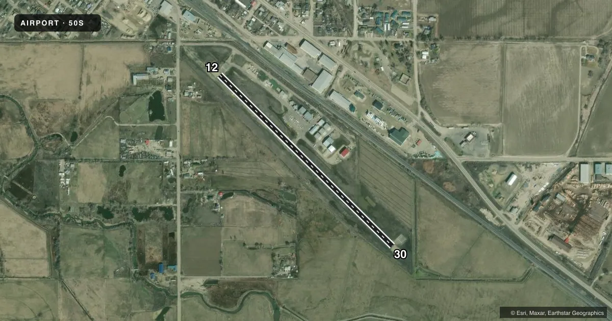
Airport sketch
Runways drawn to scale from FAA survey coordinates, rendered over satellite imagery. Not for navigation.
Approaches & charts
Services on the field
Fuel grades, oxygen, maintenance, ramp storage and lighting — as declared to the FAA by the airport operator.
Fuel & services
- Fuel
- Not available
- Oxygen (bottled)
- Not available
- Oxygen (bulk)
- Not available
- Airframe repair
- Not available
- Power plant repair
- Not available
- Other services
- AGRI,INSTR
Ramp & ground
- Transient storage
- Tie-down
- Landing fee
- No fee published
- Lighting schedule
- SS-SR
- Wind indicator
- Yes
- Segmented circle
- Yes
Fuel & FBOs
Cheapest 100LL and Jet A on the field and nearby. Always confirm with the FBO before taxi.
Airport notes
Surface conditions, obstructions, local procedures, lighting outages and other notes published with each FAA cycle.
General notes
- RWY 12: NUMEROUS ADDITIONAL OBSTRUCTIONS ON APPROACH TO RWY 12 (SEVERAL COMMERCIAL WAREHOUSE BLDGS, POWER LINE AND TREES).
- FOR CD CTC BIG SKY APCH AT 208-364-5860/5861.
Runway surface & condition
- 12/30RCMD LAND RWY 30; TKOF RWY 12 WHEN WIND COND PERMIT.
Approach & departure obstructions
- 303' FENCE AT 199', 115' RIGHT
Other notes
- ESTABD PRIOR TO 15 MAY 1959.
VFR map & nearby airports
VFR sectional. Tap any ICAO chip to open that airport.
Key facts · 50S
Answer card- ICAO
- 50S
- Name
- PARMA
- Location
- PARMA, IDAHO
- Elevation
- 2,228 ft MSL
- Traffic pattern altitude
- 3,228 ft MSL (1,000 AGL)
- Control tower
- Non-towered (use CTAF)
- Total runways
- 1
- Longest runway
- 12/30 · 2,700 ft
- Published ILS approaches
- 0
- Published frequencies
- 1
- Magnetic variation
- 17°
- Current flight rules
- MVFR
- Current wind
- 250° at 6 kt
- Favored runway now
- RWY 30
Parma Airport (50S) sits in Parma, Idaho. The field elevation is 2,228 ft MSL. It has one runway. Runway 12/30 is 2,700 ft asphalt, so this is a short local field rather than a place to plan on extra margin. There is no control tower. CTAF is 122.9. No ILS approaches are published here.
The pattern altitude is not published. Use the standard 1,000 ft AGL for light piston operations unless local guidance says otherwise. The published remarks matter here. Runway 30 is the preferred landing runway when wind allows. Runway 12 is the takeoff runway when conditions permit. Runway 12 also has several approach obstructions, including warehouse buildings, power lines and trees. There is also a 3-foot fence near the runway end on the 30 side. That makes a careful look at winds, approach path and takeoff performance important before you go.
No on-field FBOs are listed. Verify services with the airport operator or call the field on CTAF before arrival. For clearance delivery, the Chart Supplement directs pilots to Big Sky Approach at 208-364-5860 or 208-364-5861. If you are planning a first visit, review the current Chart Supplement for any updated local procedures before you depart.