METAR & TAF L49
L49 does not publish a METAR.
Showing the nearest reporting station: KONO (ONTARIO MUNI) · 5.1 NM away. Conditions at L49 may differ.
METAR · KONO
Observed 16:15Z
KONO 271615Z AUTO 27006KT 2 1/2SM HZ OVC016 25/09 A3002 RMK AO2 T02500089
- Wind
- 270° @ 6 kt
- Visibility
- 0.5 SM
- Temp / Dew
- 25°C / 9°C
- Altimeter
- 30.02 inHg
- Clouds
- OVC
- Density alt
- 3,754 ft
- Ceiling
- 1,600 ft AGL
- Rules
- LIFR
Airport info & contacts
Manager on record, flight service, ARTCC, attendance schedule and pattern altitude — published by the FAA and refreshed every 28 days.
Location
- From city
- 5 NM NNE
- VFR sectional
- KLAMATH FALLS
- ARTCC
- ZLC · SALT LAKE CITY
- NOTAM facility
- MMV (NOTAM-D)
Airport manager
- Name
- NIKITA CLARK
- Phone
- 808-343-0599
- Address
- P.O. BOX 155, ONTARIO OR 97914
Flight service · Hours
- FSS MMV
- MC MINNVILLE1-800-WX-BRIEF
Frequencies
Tap any row to copy the frequency to your clipboard.
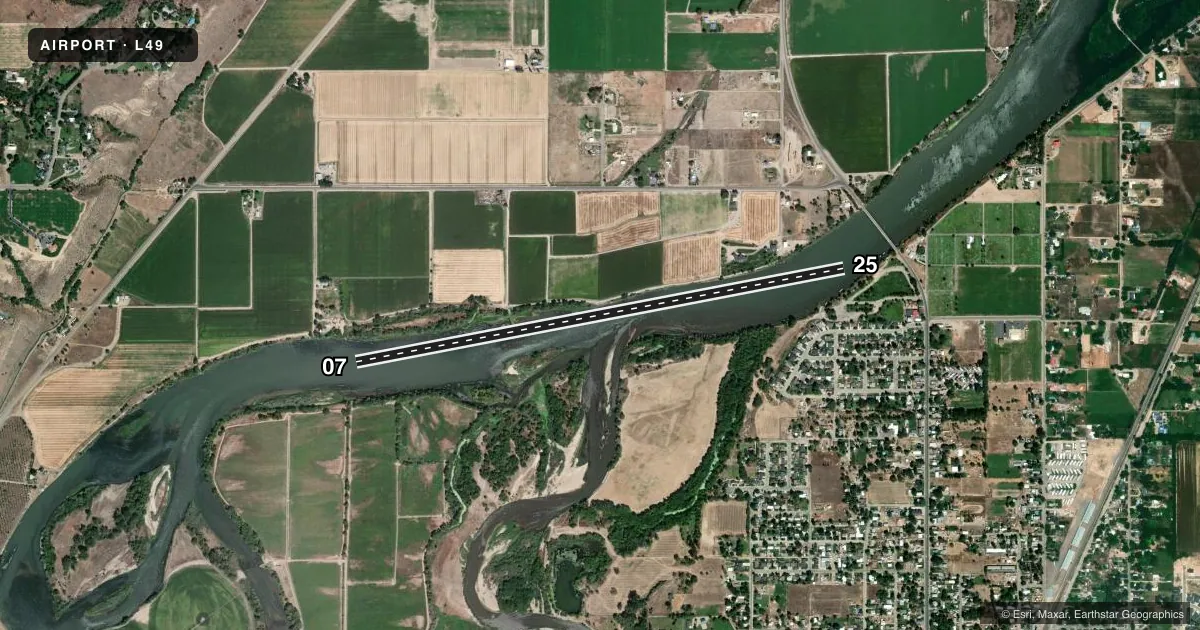
Runways & pattern
Full pagePattern entry · RWY 25
RIGHT TRAFFICAirport sketch
Runways drawn to scale from FAA survey coordinates, rendered over satellite imagery. Not for navigation.
Approaches & charts
Services on the field
Fuel grades, oxygen, maintenance, ramp storage and lighting — as declared to the FAA by the airport operator.
Fuel & services
- Fuel
- Not available
Ramp & ground
- Transient storage
- Not published
- Segmented circle
- No
Fuel & FBOs
Cheapest 100LL and Jet A on the field and nearby. Always confirm with the FBO before taxi.
Airport notes
Surface conditions, obstructions, local procedures, lighting outages and other notes published with each FAA cycle.
VFR map & nearby airports
VFR sectional. Tap any ICAO chip to open that airport.
Key facts · L49
Answer card- ICAO
- L49
- Name
- LARK'S LDG
- Location
- ONTARIO, OREGON
- Elevation
- 2,160 ft MSL
- Traffic pattern altitude
- 3,160 ft MSL (1,000 AGL)
- Control tower
- Non-towered (use CTAF)
- Total runways
- 1
- Longest runway
- 07/25 · 5,600 ft
- Published ILS approaches
- 0
- Published frequencies
- 0
- Magnetic variation
- –
- Current flight rules
- LIFR
- Current wind
- 270° at 6 kt
- Favored runway now
- RWY 25
Lark's Ldg is in Ontario, Oregon. Field elevation is 2,160 ft MSL. The airport has one runway. The longest is 5,600 ft on the water runway 07/25. This is a non-towered field. No tower hours are published because there is no control tower. No ILS approaches are published.
Pattern altitude is not published. Use the standard 1,000 ft AGL pattern for light piston operations unless the current Chart Supplement says otherwise. That puts the pattern at about 3,160 ft MSL based on the field elevation. The runway headings are 07/25. The published magnetic headings are 79.1221013017193° and 259.122101301719°. There are no on-field FBOs listed. There are also no published remarks in the facts provided.
For a first-time arrival, the main thing to plan for is that this is a water runway with no tower and no published ILS. Get the current Chart Supplement before you go. Verify local procedures, pattern direction and any operational notes with the airport operator or the field directly before arrival. With no frequencies listed in the facts, make sure you have the current communication plan from official sources before you launch.